Еженедельник OSM 850
Мы ищем волонтеров для помощи в переводе! Пожалуйста, свяжитесь с нами.: info@weeklyOSM.eu
29/10/2026-04/11/2026
Mapping
- The iD tagging schema v7.3.0 was released, bringing new features to iD, GoMap!!, EveryDoor, and other editors. It includes several new, better icons. A number of new structural definitions are now available for editing software. Presets now state, for example, that nodes within
power=lineare more likely to bepower=towerthan, for example,waterway=waterfall. Information about more relation roles was also added. Note that editing software needs to be updated to use this new info. Also included were many other improvements, new presets forrailway=platform_edgeand more. Many icon improvements, bugfixes, tweaks and documentation improvements. 151 changes in total. Thanks to all contributors!
Mapping campaigns
- Tykayn is inviting people on Mastodon to contribute to the France Project of the Month (Projet du Mois) on schools . There are 9,900 schools left to be added to OSM in the France metropolitan area, and 45,000 schools have been recorded by OSM contributors since the project began in 2025.
Community
- jfd553 has described, in his OSM diary, two years of mapping natural features around the Icefields Parkway in Alberta. It was possible to add more details with recent aerial imagery and revise previous CanVec imports. The diary links to a short video that shows an animated time-lapse OSM map that illustrates the progression of edits over this two-year journey.
Local chapter news
- The OpenStreetMap community held ► its Hackweekend in Berlin on 24 and 25 October 2026, the largest so far with 25 participants. Topics included embroidered OSM maps, LiDAR scan puzzles and a mobile redesign of the BBBike Extract Service.
Events
Geomob has announced its upcoming meetings: Lisbon on 18 November 2026 (venue to be confirmed), Berlin on 25 November 2026 at UP42 (Ohlauer Str. 43), Bristol on 24 February 2027 at The RobinHood Pub and Berlin on 3 March 2027. The first Geomob Bristol will be held in conjunction with OSGeo:UK. It is worth noting that the event will be streamed online and will serve as a trial run for FOSS4G 2027, which is due to take place in Bristol from 23 to 29 August 2027.
The organisers of Geomob tooted on their meeting held on 1 October in Berlin, at which six speakers presented innovative geodata projects including an open-source mapping platform, AI-assisted indoor mapping, cost-effective traffic light monitoring using dashcams, AI-based geospatial data analysis and the detection of dead trees using drone imagery, for which Sarah Habershon received the audience award.
On Saturday 7 November, Christopher Beddow talked ► at itWikiCon 2026 about photomapping and fotoshi, a new app that lets you link photos to features on OpenStreetMap. Photos are distributed under a CC-BY 4.0 licence but their use is permitted for the purpose of improving OpenStreetMap.
Education
Fränze Kellig reported ► that the German Foundation for Engagement and Volunteering had approved FOSSGIS’s funding application, enabling the organisation to establish an OpenStreetMap training programme. The first pilot courses will begin in January 2027, with FOSSGIS currently testing and refining the training modules with initial groups.
rphyrin attended the Humanitarian OpenStreetMap Team Global Validator Training Session 1 on 29 October 2026 and learned how to use JOSM’s Extrude tool to create complex building geometries more easily.
Maps
David Westerhoff has created a map showing where you can travel by bus and train across Germany within a selected time frame. You can also combine several starting points to find, for example, a meeting point or place of residence. The base map is based on OpenStreetMap data (OpenFreeMap), whilst the timetables come from GTFS.de (DELFI). The calculations are carried out directly in the browser.
relytworks has made Printed Canyon, a browser-based tool that transforms OpenStreetMap streets, waterways and parks, alongside Overture Maps building footprints, into city map posters and 3D-printable (STL/3MF) city models, as well as GPX tracks into 3D terrain models.
OSM in action
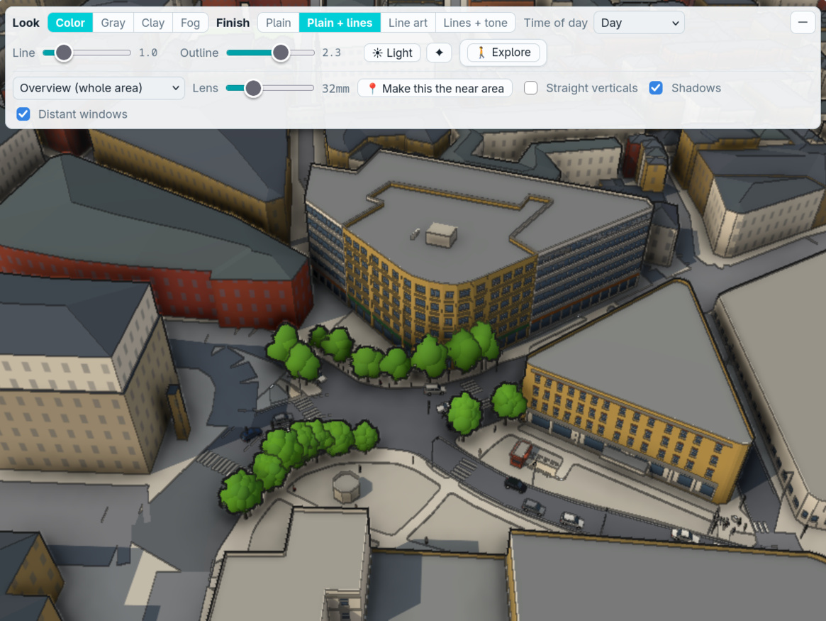
[1] MIYADAIKU (Oyasumi-Gamedev) developed a tool that automatically generates manga background illustrations using OpenStreetMap data. Users can change the location and viewpoint, as well as adjust effects and line thickness. Perhaps the day when OpenStreetMap appears in manga credits is not far away.
neketguy is developing an art project to create an interactive 3D map of Kyiv using OpenStreetMap data and elevation data from the World Resources Institute. Some landmark 3D models are also created manually using photographic references.
Raffael Meyer has released vlcbici, a web app that helps plan door-to-door trips with València’s Valenbisi bike sharing. It reads live station data from the city’s open data portal, picks a pickup station with bikes and a return station with free docks, and routes the walk, the ride and the final walk using OSRM on OSM data. A CyclOSM layer shows the cycling infrastructure. The source code is available under the MIT licence.
Open Data
Isometric Bielsko-Biała is a live pixel-art map of 456 km² of southern Poland built from OSM and Polish open data (GUGiK LiDAR and LoD2). OSM supplies the ground, the ~39k buildings newer than the LoD2 data, the road graph for a traffic microsimulation, the rail graph for timetable trains, aerialways, lamps and trails.
leaf_typedecides the species of 1 million LiDAR-detected trees.Marcelo Medina has created three tools that combine data from the 2024 Bolivian census with OpenStreetMap data. The first answers the question of where to start a business in the Cochabamba Department, the ‘2024 Census Atlas of the Cochabamba Department’ displays census data broken down by municipality, zone, neighbourhood and block, and the third lets you find nearby businesses and services.
Software
Nikandr Surkov’s phone app BlockMap, built on the open-source Arnis engine, turns any place into a playable Minecraft world. A new page shows, on central Ubud (Bali), what OpenStreetMap’s roads and buildings, Overture buildings, ESA WorldCover land cover, canopy heights and terrain each add to the world.
Simon Legner built DinoData, an OpenStreetMap tag editor inspired by Wikidata’s editing interface.
Gomal Amin has developed OpenHVRA, a hazard, vulnerability and risk assessment tool, powered by OpenStreetMap data.
Programming
Jonathon Ready demonstrated how he optimised the compact AI model Finch through supervised training and reinforcement learning so that it can answer questions about locations using OpenStreetMap data entirely offline on a smartphone. In a benchmark he developed himself, comprising 100 travel-related questions, Finch achieved the same answer quality as Gemini 3.8 Flash, provided verifiable source references significantly more often, and required only around 782 MB of memory on an iPhone 16 Pro, whilst the experiments also demonstrate how AI models can exploit vulnerabilities in automated evaluation systems.
The developers at Voygr are testing six AI language models to see whether they can reconstruct San Francisco without access to maps or the internet, using only coordinates. By comparing 41,526 points with OpenStreetMap data they demonstrated that whilst the best models correctly identify around 86 per cent of the city’s area and well-known geographical features, they largely fail to identify the exact course of the streets, even with greater computational effort.
The Leaflet GeoSearch maintainers released version 5.2.0 on 27 October. It added an OpenGeocoding provider for address autocomplete and reverse geocoding using OpenStreetMap and other open data. This release also fixed submitting search results without coordinates. The hosted API requires a key; its geocoding engine is source-available, not open source.
Simon Legner compared several existing OSM data formats, including Level0L, JOSM, and OsmChange, and explored what OSM data might look like in TOML (Tom Preston-Werner’s ‘obvious minimal language’ configuration file format).
Releases
Another month, another recap of changes to the openstreetmap website. Since the last there have been a number of small interface fixes, a first look into reducing certain inefficient database queries, and a continuation of the work around fixing issues flagged by the error monitoring tool.
Version 2.0.0-beta.1 of Leaflet has been released, introducing full tree-shaking support so applications only have to bundle the features they use. As a result a map with a tile layer now requires just 25.6 kB gzipped, down from 38 kB.
Did you know that …
- … you can set reminders for OpenStreetMap notes using NotesReminderBot? You can also explore other OSM-related bots on the wiki.
OSM in the media
- Bastian Greshake Tzovaras reported how the State of the Map LatAm conference went and why it is important, for the German magazine Amerika21.
Other “geo” things
Kieran Healy analysed New York City’s 311 service requests and complaints data from 2022 to 2025, categorised them by neighbourhood and complaint type, and visualised the results on a map.
UNESCO is launching a new comic book on the mangroves of Latin America and the Caribbean, Las visiones del manglar (the visions of mangroves), which was presented during the 17th Conference of the Parties to the Convention on Biological Diversity, taking place in Yerevan, Armenia, from 19 to 30 October 2026. The comic, in Spanish, combines illustrations, storytelling and scientific research to raise awareness of mangrove conservation, in connection with a UNESCO project.
The BBC reported that the telephone box at Dunsop Bridge, in the Ribble Valley, Lancashire, was the 100,000th telephone kiosk installed in Great Britain. It is considered a nationally significant kiosk because it stands near one of the claimed geographical centres of Great Britain.
Upcoming Events
| Country | Where | Venue | What | When |
|---|---|---|---|---|
| 🇪🇸 | Madrid | TomTom, Edificio Aqua, Calle Agustín de Foxá 4 | State of the Map España 2026 (SotMes 2026)  | 2026-11-06 - 2026-11-07 |
| 🇫🇷 | Angers | L’Arrière Train, 3 rue de Frémur, Angers | Angers Rencontre mensuelle OpenStreetMap | 2026-11-06 |
| 🇮🇳 | Bengaluru | Sanjay Nagar | OSM Bengaluru Mapping Party | 2026-11-07 |
| 🇦🇹 | Salzburg | HTL Itzling | Maker Days Salzburg | 2026-11-07 |
| 🇮🇹 | Angera | Mapathon @ Angera | 2026-11-07 | |
| Mapathon | 2026-11-08 | |||
| 🇩🇰 | København | Cafe Bevar’s | OSMmapperCPH | 2026-11-08 |
| CartONG : Mapathons en ligne 2026-2027 | 2026-11-09 | |||
| 🇹🇼 | 臺北市 | MozSpace Taipei | OpenStreetMap x Wikidata Taipei #94 | 2026-11-09 |
| 🇺🇸 | Salt Lake City | Woodbine Food Hall | OSM Utah Monthly Map Night | 2026-11-10 |
| 🇩🇪 | Magdeburg | Netz39 e.V. , Leibnizstraße 32, 39104 Magdeburg | OSM Stammtisch Magdeburg | 2026-11-10 |
| 🇩🇪 | Hamburg | “Variable”, Karolinenstraße 23 | Hamburger Mappertreffen | 2026-11-10 |
| 🇬🇧 | City of Westminster | The Volunteer pub | London pub meet-up | 2026-11-10 |
| 🇺🇸 | San Jose | Online | South Bay Map Night | 2026-11-10 |
| 🇩🇪 | temporärhaus | OSM-Stammtisch Ulm/Neu-Ulm | 2026-11-10 | |
| iD Community Chat | 2026-11-11 | |||
| 🇨🇭 | Zürich | 192. OSM-Stammtisch Zürich | 2026-11-11 | |
| 🇩🇪 | München | Echardinger Einkehr | Münchner OSM-Treffen | 2026-11-11 |
| OSM US Mappy Hour: Mapping Route 66 Past & Present | 2026-11-11 | |||
| 🇨🇿 | Olomouc | Přírodovědecká fakulta Univerzity Palackého | Olomoucký listopadový mapathon | 2026-11-12 |
| 🇩🇪 | Berlin | Neumanns | 221. OSM-Stammtisch Berlin-Brandenburg | 2026-11-12 |
| 🇫🇷 | Tours | Étape 84 | [Tours] Rencontre locale de novembre 2026 | 2026-11-12 |
| 🇩🇪 | Bochum | Das Labor, Alleestraße 50, Bochum | OSM-Treffen Bochum | 2026-11-12 |
| 🇮🇳 | Kottayam | Kottayam, Kerala | State of the Map Kerala (SoTM Kerala) | 2026-11-14 - 2026-11-15 |
| 🇮🇪 | Dublin | 4 Inns Court, Winetavern Street, Dublin, D08 XY00 | OpenStreetMap Ireland AGM - 2026 | 2026-11-14 |
| 🇮🇳 | New Delhi | South Delhi | OSM Delhi Mapping Party No.34 (South Zone) | 2026-11-15 |
| CartONG : Mapathons en ligne 2026-2027 | 2026-11-16 | |||
| Missing Maps London Mid-Month for Advanced Mappers (no training provided) (Online) [eng] | 2026-11-17 | |||
| 🇫🇷 | Lyon | Tubà | Réunion du groupe local de Lyon | 2026-11-17 |
| 🇩🇪 | Chemnitz | Kaffeesatz, Chemnitz | OSM-Stammtisch Chemnitz | 2026-11-17 |
| 🇩🇪 | Bonn | Dotty’s | 206. OSM-Stammtisch Bonn | 2026-11-17 |
| 🇩🇪 | Berlin | Online | FOSSGIS AG OSM und Outdoor | 2026-11-17 |
| 🇩🇪 | Online | Lüneburger Mappertreffen (online) | 2026-11-17 | |
| 🇬🇧 | Mott MacDonald Offices | Mott MacDonald GIS Day Mapathon [18/10/2026] | 2026-11-18 | |
| 🇬🇧 | Manchester | Pegasus Group Mapathon Charity Day | 2026-11-18 | |
| 🇺🇸 | Cal Poly Humboldt Library 121 | Cal Poly Humboldt GIS Day Mapathon | 2026-11-18 | |
| 🇩🇪 | Karlsruhe | Schwarzer Kater | Stammtisch Karlsruhe | 2026-11-18 |
| 🇨🇿 | Praha | Kanceláře Lékařů bez hranic - Qubix | Pražský GeoWeek mapathon s Lékaři bez hranic | 2026-11-19 |
| GeoWeek Luxembourg Mapathon [FR/EN] - Hybrid | 2026-11-19 | |||
| 🇧🇪 | Gent | Gemeenschappelijke ruimte Wijgaard | Meetup in Gent | 2026-11-19 |
| OSMF Engineering Working Group meeting | 2026-11-20 | |||
| 🇬🇧 | Leicester | University of Leicester | Friends of MSF Leicester Mapathon | 2026-11-20 |
| 🇫🇷 | Metz | Espace Arob@se - Metz | Atelier OpenStreetMap Metz | 2026-11-21 |
| 🇫🇮 | Espoo | Aalto-University, Space 21. | OSM Suomi 2026 | 2026-11-21 |
| 🇩🇪 | Magrathea Laboratories e.V. | 1. OSM Stammtisch Fulda | 2026-11-22 | |
| CartONG : Mapathons en ligne 2026-2027 | 2026-11-23 | |||
| 🇨🇿 | Brno | Univerzitní kampus Bohunice, Kamenice 753/5, Brno, | Listopadový brněnský Missing Maps Mapathon na Ústavu botaniky a zoologie | 2026-11-23 |
| 🇬🇧 | Llanfairfechan Library | Mapwyr Cymru: Mapathon Gogledd Cymru #2 🏴 | 2026-11-23 | |
| 🇩🇪 | Stadtgebiet Bremen | Online und im Hackerspace Bremen | Bremer Mappertreffen | 2026-11-23 |
This weeklyOSM was produced by MatthiasMatthias, PierZen, Raquel Dezidério Souto, Strubbl, Andrew Davidson, barefootstache, derFred, mcliquid.
We welcome link suggestions for the next issue via this form and look forward to your contributions.
Оставить комментарий