OSMkilawiki 851
We are looking for volunteers to help us translate! Please get in touch with us: info@weeklyOSM.eu
05/11/2026-11/11/2026
Mapping
- Telegram Sam proposed tagging seaplane bases with
aeroway=seaplane_baseinstead ofaeroway=aerodrome, as they have no runways or aprons and more closely resemble harbours. The water landing area should useseamark:type=seaplane_landing_areainstead ofaeroway=runway, whilelanduse=industrialwithindustrial=portprevents retagged bases from disappearing from maps. The discussion is ongoing in the forum.
MaggieMaps and Jake Low are proposing to describe wetlands using the new keys wetland:connectivity, wetland:vegetation, and wetland:landform to specify their water source, vegetation, and terrain position, and extending the use of salt=* and anthropogenic=yes to wetlands. OpenStreetMap US is working with the Environmental Policy Innovation Center on OpenWetlandsMap, an OSM-based dataset. The discussion is ongoing on the Wiki and in the OpenStreetMap US Slack.
Mapping campaigns
- Rphyrin used osm_pantau to highlight where mappers participated in the HOT Global Solidarity Mapathon 1 on Friday 6 November 2026.
Community
Rtnf has noticed a growing trend of new tools bringing the Wikidata and OpenStreetMap ecosystems closer together.
OSM user infraboiii has analysed the current state of vending machine tagging in France.
In the interview at OpenCage, Frank März shared the story behind OpenFireMap, a free web map of fire stations, hydrants, water supply points, and defibrillators from OpenStreetMap data across dozens of European countries. He rebuilt the map with AI assistance and it now serves pre-computed data for most countries with Overpass as a backup.
Mateusz Konieczny worked on improving iD and its tagging schema, with funding from the OpenStreetMap Foundation and the European Union through the NLnet Foundation, and has shared an update on the work completed so far.
Following a thread on the OSM Community forum, the OpenStreetMap France community started drafting rules to be applied on the forum given the recent influx of generative artificial intelligence issues such as servers and tools overload, wrong map contributions, and self promotion of vibe-coded applications. Some reminders are given, e.g. that LLM-copied code is stolen code, the forum isn’t a self-promoting place, non-free software won’t receive support from the community, and LLM usage should not become common practice.
Andres Gomez Casanova is proposing to translate the OSM tag
buildingas ‘Edificación’, a Spanish term encompassing any built structure, regardless of size. Translating it as ’edifício’ would exclude structures such as sheds, kiosks, garages, greenhouses and petrol station canopies.Andy Mabbett, in a blog post made on Remembrance Sunday, described how war memorials and the people named on them can be recorded as open, linked data. This includes photos with transcribed names on Wikimedia Commons, a page on WikiTree, a Wikidata item and a point on OpenStreetMap. The IDs of the services are then cross-referenced so that, for example, Wikidata contains the OSM ID and the OSM point contains the Wikidata ID. The Brierley Hill war memorial served as an example.
OpenStreetMap Foundation
- Craig Allan, Chair of the OpenStreetMap Foundation Board, will speak at State of the Map Nigeria 2026 on ‘Community Mapping for Climate Change’.
Local chapter news
- Eugene Alvin Villar, on behalf of the OSMF’s Local Chapters and Communities Working Group, opened a community discussion on the application from Asociación OpenStreetMap España to become an official OSMF Local Chapter. Although its geographic scope overlaps with that of the newer OSM Català chapter, both groups have stated that they do not object to the other’s status. The discussion runs until 24 November 2026.
Events
OpenStreetMap US has announced three events: Mapping USA is back as a free two-day virtual conference on 29 and 30 January 2027, with talk proposals open. The November Mappy Hour celebrates the 100th anniversary of Route 66 on 11 November 2026, and State of the Map US will take place in Baltimore, Maryland, from 11 to 13 June 2027.
To prepare for the upcoming State of the Map Nigeria 2026, the organising team, led by Victor N Sunday, Chair of SotM Nigeria 2026, paid a courtesy visit to the University of Uyo on Friday 6 November 2026.
Diego Gonzalez Ferreiro, Chief of the Solutions and Support Unit at the United Nations Global Service Centre, will speak at State of the Map Nigeria 2026 on ‘Open Geospatial Information for Peace, Development and Resilience: The UN Mappers Approach to Capacity Building, Collaborative Mapping and Humanitarian Action’.
The Open Transport Community Conference 2026, an (un)conference about Free Software and Open Data for mobility and public transport, was held at SBB Headquarters in Bern, Switzerland, from 6 to 9 October 2026. Recordings of the event are available on media.ccc.de.
Education
- Jean-Christophe Becquet announced the return of his OpenData and OpenStreetMap course for undergraduate and master’s students at the Institut d’Urbanisme et de Géographie Alpine, Université Grenoble Alpes. The course aims to explain copyright and free licences, demonstrate the potential of open and collaborative data, and encourage students to contribute.
OSM research
- AE35 has compared 38 recreational features, such as benches, fire pits, shelters, toilets, and outdoor artworks, in OpenStreetMap Denmark and the municipal dataset GeoFA since May 2024. The increased feature count is taken as an estimation: in OSM, the total number of features increased from 57,700 to 175,500; in GeoFA, it rose from 5,300 to 15,800. This means that OSM contained 159,750 more objects, thus it was approximately 10.9 times more efficient. The full analysis of all 38 objects can be found in a Google sheet. OpenStreetMap wins on every parameter.
Maps
- Dim Kandin has made Adrenalin Spots, a map showing seasonal locations for kitesurfing, surfing, skiing, climbing, diving, sailing, and other sports throughout the year. The map covers around 580 spots and calculates a nightlife score based on nearby bars, clubs, restaurants, and cafés from OpenStreetMap data queried via Overpass, with locations within 5 km weighted more heavily than those within 15 km. The base map uses OpenFreeMap.
OSM in action
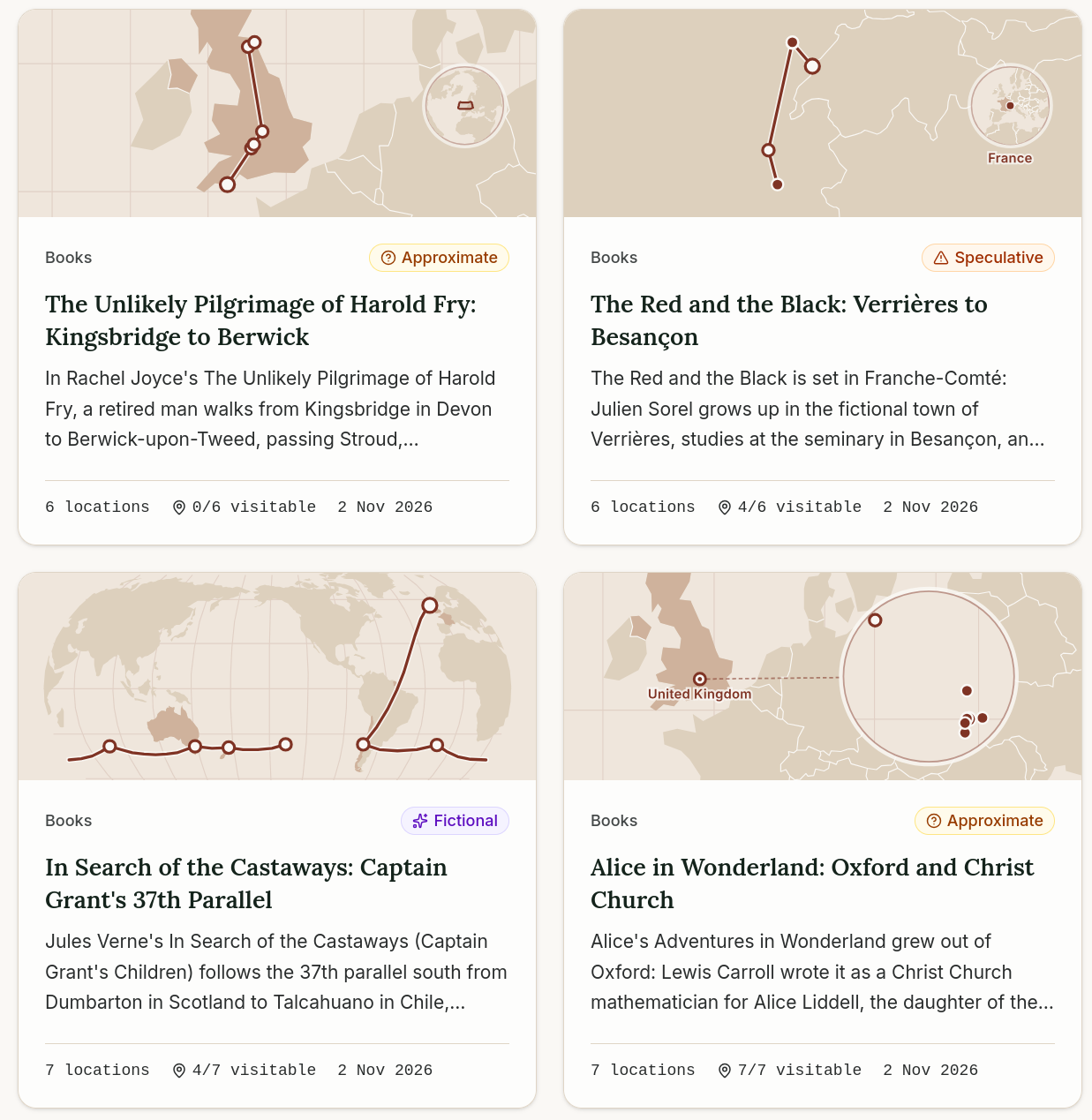
[1] Mapped Chronicles shows the real-world locations behind books, films, games, myths, and historical events on maps. Its currently 973 routes guide users through stories, stop by stop, with data, sources, and information about how accurately each location has been identified and whether it can be visited. Through the ‘Studio’, users can design their own routes and submit them for moderation review. The map is based on OpenStreetMap data.
MikeHur has been developing Wandering Around, a free browser game that lets players explore any town or city in the world using OpenStreetMap data.
Software
The Mangrove Reviews platform now allows people to import their Google Maps reviews by releasing them under an open licence, permitting their reuse in OSM-based tools like MapComplete and CoMaps.
devenzi has released ‘Devenzi Map Studio’, a WordPress plugin that embeds OpenStreetMap maps into websites without the need for an API key or account. The vector maps are sourced from OpenFreeMap and are rendered using MapLibre. They are designed in a full-screen editor featuring locations, areas, routes, and 3D buildings. If desired, the map can be set to load only after a click, ensuring that the integration is possible without a cookie banner and is GDPR-compliant.
Tina explained how to organise track data using OsmAnd’s Smart Folders feature.
A CoMaps contributor wrote a blog post about how the integration of Mangrove reviews with OSM data works.
tydo has launched ‘Tourello’, an offline app for hiking, mountain biking, and skiing (Android, iOS, macOS), which generates vector maps using OSM data via Geofabrik, elevation models from Mapterhorn, and BRouter for offline route planning. The OSM wiki lists which tags, such as
sac_scale,mtb:scale,trail_visibility, andpiste:difficultythe app evaluates. The beta version is free until the end of March 2027; a subscription service is planned thereafter, a move which drew criticism on the OSM Community forum because the app is not open source and free feedback is being sought there. Sarah Hoffmann, who operates Waymarked Trails, pointed out that the site’s terms and conditions only permit open-source, non-commercial use, whereupon tydo removed the API query and now builds the routes directly from OSM relations. According to wiki, the app is proprietary.
Programming
- Geofabrik has published terms of use for its free Postpass service, which allows users to query OSM data through PostGIS. The service is intended for learners and the OSM community. To use it, a meaningful User-Agent or Referer header is required. Scraping and repeated requests is prohibited. Geofabrik offers a paid tier for commercial users and heavily used applications, or can help them set up their own server.
Releases
- StreetComplete has just passed Apple’s review and is now officially available on the App Store.
Other “geo” things
A research team from National Cheng Kung University in Taiwan and the NASA Goddard Space Flight Centre have found that the manoeuvres carried out by the Artemis 2 rocket in April 2026 altered the ionosphere and disrupted GNSS signals. According to the study published in Geophysical Research Letters, ground-based GNSS systems recorded changes in electron density during three manoeuvres, which can lead to inaccurate position measurements.
The German Federal Cartel Office is investigating potential restrictions of completion by Google related to their map services for use in vehicle infotainment systems and is asking car manufacturers and other map service providers for input.
David Ding runs ‘Localingual’, an interactive world map where you can listen to recordings of languages and dialects. Clicking on a colour-coded country plays its voices; clicking again shows the regions; and volunteers can contribute their own recordings via their browser. Jornal Nota reported ► that by 2019 the site had around 18,000 recordings.
In an editorial, The Guardian argued that Ordnance Survey maps remain a superior way to navigate the landscape.
Upcoming Events
| Country | Where | Venue | What | When |
|---|---|---|---|---|
| 🇮🇳 | Kottayam | Kottayam, Kerala | State of the Map Kerala (SoTM Kerala)  | 2026-11-14 - 2026-11-15 |
| 🇮🇪 | Dublin | 4 Inns Court, Winetavern Street, Dublin, D08 XY00 | OpenStreetMap Ireland AGM - 2026 | 2026-11-14 |
| 🇹🇷 | Hackerspace İstanbul | OpenStreetMap İstanbul Mapathon | 2026-11-15 | |
| 🇮🇳 | Delhi | Avaya Cafe and Bakery, Green Park | OSM Delhi Mapping Party No.34 (South Zone) | 2026-11-15 |
| 🇫🇷 | Point Com | Rencontre Mapadour | 2026-11-16 | |
| Politecnico di Milano, Building 4A, Aula Fassò | Introduction to OpenStreetMap | 2026-11-16 | ||
| CartONG : Mapathons en ligne 2026-2027 | 2026-11-16 | |||
| 🇫🇷 | Grenoble | La Turbine | Réunion du groupe local de Grenoble | 2026-11-16 |
| State of the Map Nigeria(SotM Nigeria) | 2026-11-17 - 2026-11-20 | |||
| Missing Maps London Mid-Month for Advanced Mappers (no training provided) (Online) [eng] | 2026-11-17 | |||
| 🇫🇷 | Lyon | Tubà | Réunion du groupe local de Lyon | 2026-11-17 |
| 🇩🇪 | Chemnitz | Kaffeesatz, Chemnitz | OSM-Stammtisch Chemnitz | 2026-11-17 |
| 🇩🇪 | Berlin | Online | FOSSGIS AG OSM und Outdoor | 2026-11-17 |
| 🇩🇪 | Bonn | Dotty’s | 206. OSM-Stammtisch Bonn | 2026-11-17 |
| 🇩🇪 | Online | Lüneburger Mappertreffen (online) | 2026-11-17 | |
| 🇬🇧 | Mott MacDonald Offices | Mott MacDonald GIS Day Mapathon [18/10/2026] | 2026-11-18 | |
| 🇬🇧 | Manchester | Pegasus Group Mapathon Charity Day | 2026-11-18 | |
| UO GIS Day- Knight Library | Eugene Bike Infrastructure Mapathon | 2026-11-18 | ||
| 🇺🇸 | Cal Poly Humboldt Library 121 | Cal Poly Humboldt GIS Day Mapathon | 2026-11-18 | |
| Dublin Office / Online | Tetra Tech Ireland GIS Day Mapathon | 2026-11-18 | ||
| 🇫🇷 | MJC de Vienne | Réunion du groupe local de Vienne | 2026-11-18 | |
| 🇩🇪 | Karlsruhe | Schwarzer Kater | Stammtisch Karlsruhe | 2026-11-18 |
| Internationale GeoWeek - Online Mapathon ÄRZTE OHNE GRENZEN (AT/CH/DE) | 2026-11-18 | |||
| 🇨🇿 | Praha | Kanceláře Lékařů bez hranic - Qubix | Pražský GeoWeek mapathon s Lékaři bez hranic | 2026-11-19 |
| GeoWeek Luxembourg Mapathon [FR/EN] - Hybrid | 2026-11-19 | |||
| 🇧🇪 | Gent | Gemeenschappelijke ruimte Wijgaard | Meetup in Gent | 2026-11-19 |
| Jena | EGEA Jena - Mapathon | 2026-11-19 | ||
| OSMF Engineering Working Group meeting | 2026-11-20 | |||
| 🇬🇧 | Leicester | University of Leicester | Friends of MSF Leicester Mapathon | 2026-11-20 |
| 🇫🇷 | Metz | Espace Arob@se - Metz | Atelier OpenStreetMap Metz | 2026-11-21 |
| 🇫🇮 | Espoo | Aalto-University, Space 21. | OSM Suomi 2026 | 2026-11-21 |
| DTU Lyngby Building 357 + Aarhus location TBA | EWB Student Mapathon Denmark | 2026-11-22 | ||
| 🇩🇪 | Magrathea Laboratories e.V. | 1. OSM Stammtisch Fulda | 2026-11-22 | |
| 🇨🇿 | Brno | Univerzitní kampus Bohunice, Kamenice 753/5, Brno, | Listopadový brněnský Missing Maps Mapathon na Ústavu botaniky a zoologie | 2026-11-23 |
| 🇬🇧 | Llanfairfechan Library | Mapwyr Cymru: Mapathon Gogledd Cymru #2 🏴 | 2026-11-23 | |
| CartONG : Mapathons en ligne 2026-2027 | 2026-11-23 | |||
| 🇩🇪 | Stadtgebiet Bremen | Online und im Hackerspace Bremen | Bremer Mappertreffen | 2026-11-23 |
| Room VIII, Viale del Risorgimento 4, Bologna | Unibo Mapathon 2026-11 | 2026-11-24 | ||
| Pravidelný Missing Maps CZ-SK online Mapathon | 2026-11-24 | |||
| 🇺🇸 | San Jose | Online | South Bay Map Night | 2026-11-24 |
| 🇬🇧 | Derby | The Brunswick, Railway Terrace, Derby | East Midlands pub meet-up | 2026-11-24 |
| 🇩🇪 | Berlin | Online | OSM-Verkehrswende #80 | 2026-11-24 |
| 🇫🇷 | La Fabrique des possibles | Réunion du groupe local de Nancy | 2026-11-25 | |
| 🇩🇪 | Düsseldorf | Online bei https://meet.jit.si/OSM-DUS-2026 | Düsseldorfer OpenStreetMap-Treffen (online) | 2026-11-25 |
| 🇩🇪 | Würzburg | FabLab Würzburg | Würzburger OSM-Treffen | 2026-11-25 |
| 🇩🇪 | Mannheim | RaumZeitLabor, Mannheim | Rhein-Neckar OSM Treffen | 2026-11-25 |
| 🇩🇪 | Freiburg im Breisgau | CCCFR | OSM-Treffen Freiburg/Brsg. | 2026-11-25 |
| Prírodovedecká fakulta UK Bratislava | Missing Maps mapathon Bratislava #15 | 2026-11-26 | ||
| CartONG : Mapathons en ligne 2026-2027 | 2026-11-30 |
This weeklyOSM was produced by Bastian Greshake Tzovaras, MatthiasMatthias, PierZen, Strubbl, Andrew Davidson, barefootstache, derFred, vicksun.
We welcome link suggestions for the next issue via this form and look forward to your contributions.
Leave a reply