HaftalıkOSM 848
We are looking for volunteers to help us translate! Please get in touch with us: info@weeklyOSM.eu
15/10/2026-21/10/2026
Mapping
Mateusz Konieczny has proposed bot edits that would remove
wall=wallfrombarrier=wallobjects (and nowhere else) and do the same forfitness_station=yesandfitness_station=fitness_stationonleisure=fitness_station,crossing=yesonhighway=crossing,bollard=yesonbarrier=bollardobjects.Requests for comments have been made for the following proposals:
- Tykayn, aka Baptiste Lemoine, proposes phasing out
amenity=hospitalin favour ofhealthcare=hospital. Voting on this is planned to take place from 5 to 19 November. - HuggeK, PizzaTreeIsland and FairwayMapper want to use
type=sport, along withgolf=courseandgolf=tee_markers, to map golf courses with multiple courses and tee-dependent values.
Mapping campaigns
- The Ballerup Municipality announced five new MapRoulette challenges covering all five Danish regions, with nearly 90,000 tasks to help improve OpenStreetMap.
Community
Four ministries of the Government of Québec have granted explicit authorisation to incorporate their geographical data into OpenStreetMap. The OSM Contributors wiki page contains a link to the authorisations. It should be noted that the Ministry of Natural Resources and Forests limits their authorisation to the dataset explicitly mentioned. Québec contributors subsequently started a discussion on the OSM Community forum to plan the steps for integrating these significant additions of data into OpenStreetMap: reviewing administrative boundaries, integrating address points and buildings, and harmonising street names.
FooBar99 explained how aerial imagery can be used while offline mapping in JOSM. To do this, he uses the Python tool MapTilesDownloader, which downloads tiles at any zoom level.
OpenCage interviewed Sofia Pahaoja, creator of Touch Mapper, in the latest of their OpenStreetMap interview series. Touch Mapper uses OpenStreetMap data and 3D printing to create tactile maps for visually impaired people.
OpenStreetMap Foundation
The OpenStreetMap Foundation announced the election of Craig Allan (26.7%), Gregory Marler (26.4%), Héctor Ochoa Ortiz (25.7%), and Maurizio Napolitano (21.2%) to its board. All four candidates reached the required threshold in the first round and there were 1,656 voters in this election, with 595 ballots cast, of which 580 were valid.
Craig Allan presented the 2026 Chairperson’s report at the OpenStreetMap Foundation Annual General Meeting, as chair of the OSMF Board. Several other reports and documents were also presented at the meeting, including the 2026 Treasurer’s report by Roland Olbricht, the 2026 Personnel Committee’s report and the minutes of the 2025 Annual General Meeting.
The OpenStreetMap Ops Team reported that several PHP-based secondary OpenStreetMap services were temporarily offline due to a critical PHP security vulnerability.
Local chapter news
- From 2 to 4 October 2026, FOSSGIS hosted ► the FOSSGIS-OSM Community Meeting at the Linuxhotel in Essen, attended by 25 active members. Topics included association work, a Mapnik-style replica of OpenSeaMap for map printing using print.get-map.org, and an exchange of experiences regarding the Panoramax instance. The results are documented on the wiki.
Events
Stefan Keller is inviting you to a webinar on enterprise data integration with Apache Hop on 27 October 2026 from 11:00 to 12:00 CET. It is online and free of charge. The webinar will cover the latest version, the current status of the GIS plugins, and two case studies from Glue Software Engineering AG.
KonGeoS, the conference for geodesy students from the German speaking region, took place at Mainz University of Applied Sciences from 15 to 17 October 2026. At the exhibitors’ forum, FOSSGIS members provided ► information about open-source GIS, OpenStreetMap, and the association.
Katja Haferkorn reported ► on the Smart Country Convention in Berlin, where FOSSGIS e.V. was represented at the lat/lon GmbH stand in the Open Source Park.
Education
- The Spatial Workflow team have assessed OpenStreetMap data completeness in Washington, DC (US), by comparing OSM’s road network with the Census Bureau’s TIGER roads, analysing building and road growth curves using full OSM history data via the ohsome API, and measuring the completeness of key attributes.
Maps
The web app atm.gr lists ATMs across Greece on a map and in a searchable list, using OSM
amenity=atmdata combined with data from the banks and refreshed weekly. Attributes missing in OSM are shown as unknown, which indicates to local mappers where data can be improved.The Institute of Geography at the Autonomous University of Mexico maintains a web map of geosites, based on OpenStreetMap and Leaflet. Knowledge of geohistory is essential for promoting its appreciation and fostering its conservation. In this regard, the identification, documentation, and dissemination of geosites help bring the Earth sciences closer to different sectors of society and contribute to a greater understanding of the land and the natural processes that shaped it.
At efimereuonta-nosokomeia.gr there is an independent free service that shows Greece’s hospitals on a map and in a list, including telephone numbers, directions and details of their Accident and Emergency departments. The map is based on OpenStreetMap, and the list works even without an internet connection. No registration is required, and a separate page shows which hospitals are on call today. For emergencies, the home page provides direct links to the numbers 166 (EKAB) and 112.
MapQuest has added a Halloween-themed Surveillance layer to their Android and iOS applications based on OSM
man_made=surveillancedata.OsmAnd has updated its terrain maps and contour lines for the United States, Canada, and Mexico, using high-resolution national elevation data from the USGS, NRCan, and INEGI. The new data has about a 10 m resolution in the mainland US and about 30 m in Alaska and most of Canada and Mexico, so smaller ridges and steeper cliffs are now visible.
OSM in action
- Jan Kryšpín has launched North Up Daily, a daily map puzzle in which you have to reorient 16 rotated map tiles so that roads and rivers line up correctly, and then guess the location. The game is free to play and requires no account. If you want more, you can practise as much as you like in practice mode or compete on the leaderboard. The map data is sourced from OpenStreetMap.
Software
Geocracia, a Brazilian news portal, released its AI prompt (beta version) but there is no OpenStreetMap attribution, even after contacting the developer about this problem.
In episode 313 of the Freakshow podcast, Tim Pritlove introduced ► Kugelblitz, a 3D globe browser ► for macOS that uses various data sources, including Sentinel-2 Cloudless, NASA Blue Marble, Earth at Night, Natural Earth, Mapterhorn, and OpenStreetMap.
Ratafuel is a free, open-source Android app that helps you find the cheapest fuel nearby in France. It combines open data on fuel prices with OpenStreetMap data on petrol stations. You can filter stations by fuel type, search for them in a selected town, and open a route in a sat-nav app. Ratafuel contains no adverts or trackers; access to your location is optional.
Stadia Maps explained that a recent update pays closer attention to land cover processing and presentation in the Alidade Bright, Outdoors, and Stamen Terrain map styles.
Gigazine explained how to use Vespucci, a free, full-featured mobile app for editing OpenStreetMap data.
Programming
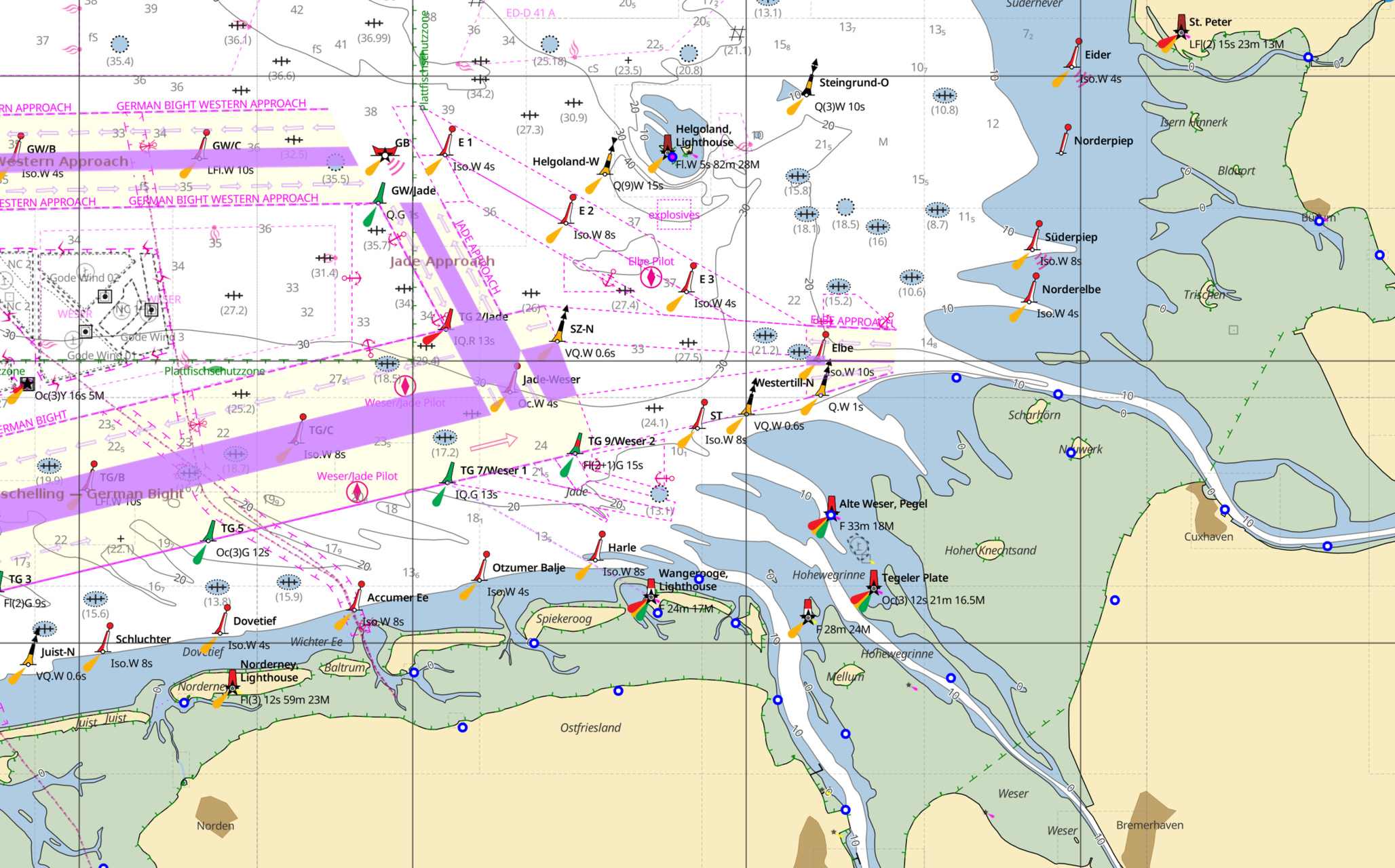
[1] Adam Lucke has developed FreeNauticalChart.net, an open-sourced and open-data project that aims to provide free nautical charts.
Sarah Hoffmann reported that OpenStreetMap has not yet decided whether or not to participate in GSoC 2027. Students are advised not to get involved in projects before the participation announcement in March 2027, when OpenStreetMap’s participation will be confirmed.
Releases
Simon Legner has released Maplair 4.0.0, an open-source JavaScript library for interactive maps, forked from Leaflet. It integrates features that previously required plugins or workarounds in Leaflet applications, including map rotation, fullscreen mode, search, heatmaps, a minimap, and legends.
Rphyrin released version 26.10.16 of whathappened.here, a social check-in and review application built on OpenStreetMap. This update added shareable permalinks for user and location pages.
Tobias Zwick has released StreetComplete version 64.0, which is the first stable iOS version of this editor. It may take some time for the app to become available in the App Store.
Did you know that …
- Daniel Schep has presented OSM Kids! at the SotM 2026 Lightning Talks. The talk was previously given at Mapping USA 2026 (we reported earlier).
OSM in the media
Jakub Waller’s Papamap was featured on German Televison channel NDR.
Chase DiBenedetto, of Mashable, explained how commuters can avoid Flock cameras using MapQuest, a navigation app launched in 1996. Its recently introduced ‘Surveillance Layer’ allows users to locate nearby Flock cameras and other surveillance systems. According to MapQuest’s terms, the data comes from OpenStreetMap contributors.
Other “geo” things
The Regional Court of Frankfurt am Main has ruled , in a judgment that is not yet final , that Google is prohibited from publishing 3D images of a residential property. German case law on the matter is inconsistent, as the Regional Court of Itzehoe reached a different decision in a similar case in 2020.
Before dominating the oceans with its fleets, Portugal legally built ► its right to navigate them, conquer them, and exclude its rivals. From the pontifical legitimacy of the Portuguese monarchy to the bulls of the 15th century and the Treaty of Tordesillas, the political and legal foundations of the mare clausum transformed the ocean into a space of sovereignty and overseas expansion.
In his newsletter, Mapas Milhaud, Miguel García Álvarez presented ► twelve browser-based geography games. These included WorldGuessr (guessing locations using Street View), TimeGuessr (estimating the location and year a photo was taken), Worldle (recognising countries from their silhouettes) and Travle (naming countries as a chain of connections). His personal favourite is GeoGrid, in which you fill in a 3×3 grid.
Upcoming Events
| Country | Where | Venue | What | When |
|---|---|---|---|---|
| 🇮🇳 | Ernakulam | Edapally, Kochi | Kochi Mapping Party 2026  | 2026-10-24 - 2026-10-25 |
| 🇮🇹 | Pordenone | Consorzio Universitario Pordenone | Linux Day a Pordenone | 2026-10-24 |
| 🇮🇹 | Bologna | Liceo Copernico di Bologna | Linux Day 2026 a Bologna | 2026-10-24 |
| 🇮🇹 | Parma | Officine On/Off Parma | Linux Day 2026 Parma | 2026-10-24 |
| 🇫🇷 | Inclu K’fé | Cartopartie à Orx | 2026-10-24 | |
| 🇮🇹 | Biblioteca comunale Alda Merini | Linux Day Casorate Sempione 2026 | 2026-10-24 | |
| 🇩🇪 | Berlin | Wikimedia e.V. Tempelhofer Ufer 23-24,10963 Berlin | OSM Hackweekend Berlin-Brandenburg 10/2026 | 2026-10-24 - 2026-10-25 |
| 🇸🇪 | Uppsala | Datorföreningen Update | Mapping meetup in Uppsala | 2026-10-25 |
| 🇮🇳 | Bengaluru | Olive Street Food Cafe, 7th Cross Road, BTM Layout | OSM Bangalore Mapping Party | 2026-10-25 |
| 🇮🇳 | Noida | Noida | OSM Delhi NCR Mapping Party No.33 (Noida) | 2026-10-25 |
| a11y-Score: ein OSM-Barrierefreiheitswerkzeug | 2026-10-26 | |||
| CartONG : Mapathons en ligne 2026-2027 | 2026-10-26 | |||
| 🇮🇹 | Milano | Formazione Wikimedia Italia - OpenStreetMap: tasking manager | 2026-10-26 | |
| 🇩🇪 | Heidelberg | DEZERNAT#16 | Rhein-Neckar OSM Treffen | 2026-10-26 |
| 🇩🇪 | Stadtgebiet Bremen | Online und im Hackerspace Bremen | Bremer Mappertreffen | 2026-10-26 |
| 🇫🇷 | Saint-Étienne | Zoomacom | Rencontre Saint-Étienne et sud Loire | 2026-10-26 |
| 🇲🇽 | Ciudad de México | Antiguo Colegio de San Ildefonso | State of the Map Latam 2026 | 2026-10-27 - 2026-10-29 |
| Pravidelný Missing Maps CZ-SK online Mapathon | 2026-10-27 | |||
| 🇪🇸 | Madrid | Online | Mappy Hour OSM España | 2026-10-27 |
| 🇺🇸 | San Jose | Online | South Bay Map Night | 2026-10-27 |
| 🇦🇹 | Wien | Schlupfwinkel (Kleine Neugasse 10, 1040 Wien) | 80. Wiener OSM-Stammtisch | 2026-10-27 |
| 🇬🇧 | Derby | The Brunswick, Railway Terrace, Derby | East Midlands pub meet-up | 2026-10-27 |
| 🇫🇷 | La Fabrique des possibles | Réunion du groupe local de Nancy | 2026-10-28 | |
| 🇩🇪 | Düsseldorf | Online bei https://meet.jit.si/OSM-DUS-2026 | Düsseldorfer OpenStreetMap-Treffen (online) | 2026-10-28 |
| 🇩🇪 | Würzburg | FabLab Würzburg | Würzburger OSM-Treffen | 2026-10-28 |
| 🇨🇭 | Rapperswil-Jona | OST RJ Gebäude 6, Rapperswil | 20. Mapathon & Mapping Party Rapperswil 2026 | 2026-10-30 |
| 🇮🇹 | Pesaro | Biblioteca-Archivio “Vittorio Bobbato” | Linux Day Pesaro | 2026-10-31 |
| 🇮🇳 | नई दिल्ली | Jitsi Meet (online) | OSM India - Monthly Online Mapathon | 2026-11-01 |
| 🇩🇪 | Hannover | Kuriosum | Stammtisch | 2026-11-02 |
| 🇨🇭 | Bern | Provisorium46 | Berner OpenStreetMap-Znacht | 2026-11-03 |
| Missing Maps London Mapathon Beginner Friendly (with Training) (Online) [eng] | 2026-11-03 | |||
| 🇩🇪 | Stuttgart | Forum 3 Café | Stuttgarter OpenStreetMap-Treffen | 2026-11-04 |
| 🇫🇷 | Bar Le Schmilblik | Rencontre mensuelle des contributeurs Paris sud | 2026-11-05 | |
| 🇫🇷 | Angers | L’Arrière Train, 3 rue de Frémur, Angers | Angers Rencontre mensuelle OpenStreetMap | 2026-11-06 |
| 🇦🇹 | Salzburg | HTL Itzling | Maker Days Salzburg | 2026-11-07 |
| 🇮🇹 | Angera | Mapathon @ Angera | 2026-11-07 | |
| 🇩🇰 | København | Cafe Bevar’s | OSMmapperCPH | 2026-11-08 |
| CartONG : Mapathons en ligne 2026-2027 | 2026-11-09 | |||
| 🇹🇼 | 臺北市 | MozSpace Taipei | OpenStreetMap x Wikidata Taipei #94 | 2026-11-09 |
This weeklyOSM was produced by MarcoR, MatthiasMatthias, Raquel Dezidério Souto, Strubbl, Andrew Davidson, barefootstache, derFred.
We welcome link suggestions for the next issue via this form and look forward to your contributions.
Leave a reply