28/03/2024-03/04/2024
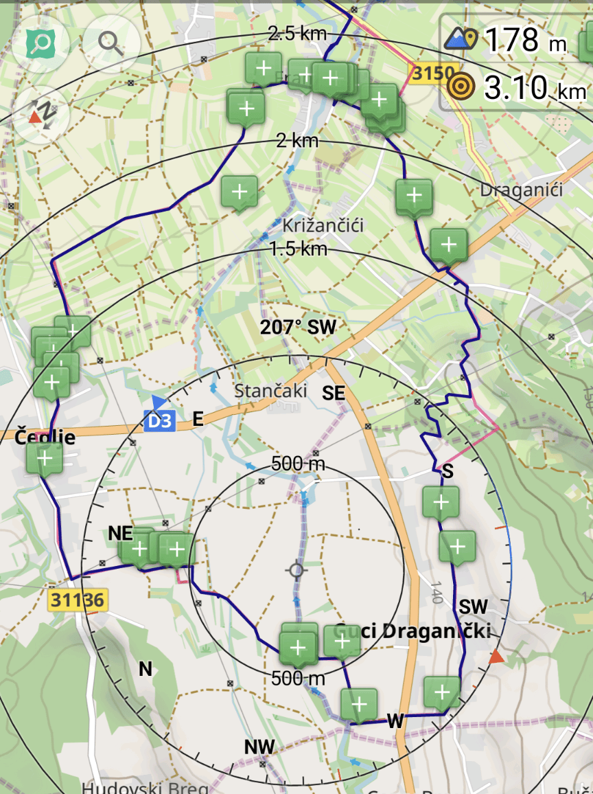
Route planned, obstacles found and then bridge, bench, ditch, etc. mapped [1] | © barfootstache & OsmAnd | map data © OpenStreetMap contributors
Mapping
- [1] barefootstache explored the Croatian countryside, not hesitating while being soaked traversing waterway crossings.
- GovernorKeagan has shared his journey of detailed mapping in Gqeberha (Port Elizabeth, South Africa), focusing on adding buildings and details missing in his hometown, highlighting the therapeutic aspect of the task and plans for more structured updates and screenshots to document progress.
- Jfd553 has documented his detailed mapping project on the Magdalen Islands. The project involved correcting existing data and enriching the map with new features based on local knowledge over a nine-month period.
- OMNIBUS, from ReDHumus
 ►, has written a diary entry regarding his participation in the #UNMappers validation training. In particular he shares how he uses the ‘Who did it’ RSS generator to track changes in the map for his area of interest, and how to publish the timeline on a website for non-techy users.
 - Supaplex described in detail a successful mapping workshop, organised by OpenStreetMap Taiwan and TomTom, held at the National Cheng Kung University, focusing on local project creation with the HOT Tasking Manager. The workshop trained 22 students, who contributed to mapping 369 buildings in the Xiejie District of Tainan City.
- Voting on the extended tagging of
traffic_signproposal is open until Monday 15 April.
 ►
►
Mapping campaigns
- Brazil Singh shared their experience with the Open Mapping Hub Asia Pacific from HOT and World Vision Bangladesh, detailing a field mapping and data collection effort in Mirpur and Duaripara, a neighbourhood in Dhaka.
- The Austrian community has taken a collective approach in processing about 5000 map notes and about 2000 notes have already been closed in a short time. Currently, less than 3000 are still open. If you also want to help, there are a number of useful tools available:
Community
- Anne-Karoline Distel discussed her initial week with a camera grant for EU mapping, capturing over 12,643 images on bike and foot, including mapping a new bus route to St. Mullin’s and adding new features to OSM.
- April Fools:
- On 1 April Osm2pgsql went AI with a new cool AI generated logo. Amanda McCann reacted by saying ‘we shouldn’t let #AI anywhere near the code section’.
- StreetComplete showed a 🌈 rainbow #EasterEgg to replace the direction logo. Ludovic realised a rainbow nyan cat follows his edits and gislars felt followed by a rainbow trace.
- TrickFoxy proposed ⚡⚡⚡ OSM API v1.0⁴. This proposal was stamped and approved by Kamil Monicz. This ignited some serious discussion regarding future improvements for OSM API.
- Kamil Monicz’s third development diary for OpenStreetMap NextGen detailed updates such as the integration of features, a refreshed changeset user interface, support for the Rapid editor, a new icon system, improved pagination of elements, and native support for complex tagging schemas.
- Sven Geggus evaluated the progress of campsite tagging over the past decade (we reported earlier), noting a reduction in the number of sites with insufficient tagging from 70% to 47%, but acknowledging that much work remains to be done, with 81,880 sites still inadequately tagged.
- Volker Krause recapped his experience at the FOSSGIS Conference 2024 in Hamburg, Germany, with a focus on indoor navigation and public transport. Highlights include successful indoor OSM user meetings, updates in indoor localisation research, and BIM to OSM conversion efforts. Krause also explored public transport advancements relevant to Transitous and discussed the growing importance of open data and free software in public administration.
OpenStreetMap Foundation
- The OpenStreetMap Foundation has scheduled this year’s General Meeting and board elections for Saturday 19 October. To run for the Board you must be a member of the Foundation by Monday 22 April. There are four Board positions up for election this year. The election date has been adjusted to avoid a conflict with the presentation of the Financial Report.
Events
- Vitor announced the development of the State of the Map Latam 2024 website, scheduled for 7 and 8 December in Belém, Brazil, and called for community members, with web development experience, to collaborate on the project using Jekyll and a template from previous conferences.
- The FOSS4G SotM Oceania 2024 will take place in Hobart, Tasmania, Australia, from 5 to 8 November. The call for papers is open until Friday 31 May.
- Videos of the FOSSGIS 2024 conference are now available . They provide access to a range of presentations and workshops covering topics such as QGIS, OpenStreetMap data evaluation, open data strategies, comprehensive overview of current trends, and developments in open source geospatial technology.
- The State of the Map (SotM) 2024 conference is calling for papers for its hybrid event being held in Nairobi, Kenya, and online. The event, the first international SotM in Africa, is seeking presentations in a variety of tracks, including OSM Basics, Community, Mapping, Cartography, Software Development, Data Analysis, and User Experience. Submissions must be made by Tuesday 23 April.
- On Monday 1 April Umbraosmbr held a mapping workshop for beginners on OpenStreetMap as part of the Mapeia Belém Project initiative, which aims to update data on the limit of the Legal Amazon and also train new mappers to join collaborative mapping. The recordings are available on YouTube and you can find more information in umbraosmbr’s blog posts: 1 and 2.
 . They provide access to a range of presentations and workshops covering topics such as QGIS, OpenStreetMap data evaluation, open data strategies, comprehensive overview of current trends, and developments in open source geospatial technology.
 available on YouTube and you can find more information in umbraosmbr’s blog posts:
 OSM research
- An article in The International Archives of the Photogrammetry, Remote Sensing and Spatial Information Sciences from 2022 discussed a collaborative mapping strategy developed for slum upgrading in Bogotá, Colombia, detailing the creation of a methodology for remote data collection in a South American informal settlement. It highlights the benefits of collaboration between different stakeholders, including local NGOs and international volunteers, using OpenStreetMap and Mapillary to map over 700 points of interest in a Bogotá slum, and highlights the potential of the methodology to be replicated in similar contexts to improve living conditions through detailed and accessible mapping.
Humanitarian OSM
- Pete Masters’ video shows how open data collected by MapSwipe users in the flood-affected areas of Libya is helping humanitarian aid workers and mappers to locate settlements for inclusion in OpenStreetMap.
Maps
- Robin Wilson has launched a web app which allows you to search and view British placenames on an OSM map background. You can search to find names that, for example, start with ‘great’, end with ‘burgh’, or contain ‘sea’, showing the fascinating patterns of names and their various sources in Britain.
- In the outdoorseiten.net forum ►, there is a uMap map, created by Wafer, that now includes 5000 shelters, water points, and other objects of interest for hikers and bike travellers. All have been visited, described, and photographed by volunteers. The map currently covers Germany and surrounding areas but can be expanded worldwide.
Those who want to participate need to register in the forum and can report► their observations in the post. - Tracestrack have started rendering
sac_scaleandtrail_visibilitytags in their topographic maps.
Software
- Stadia Maps announced the release of their latest endpoint, ‘Cacheable Static Maps’, expanding their ‘Static Map Images’ API with special terms to enable new use cases in digital projects like CDNs and static sites, as well as in print materials such as brochures and books.
- Olivia Hudson, at Gearrice, highlighted Organic Maps as the preferred open source alternative to Google Maps and Waze for Android Auto users, highlighting its offline map downloads, Android Auto compatibility, and customisation options.
Programming
- retiolus has developed the osm2gmaps app over the past two weeks. It facilitates conversion between OSM-based app links and those for Google Maps, Apple Maps, Magic Earth, and vice versa, enhanced by user feedback.
- Robin Wilson has written a blog post showing how easy it is to self-host OSM-based routing using Valhalla and Docker, including Python code to process the Valhalla output.
Releases
- The Vespucci 20.0.0 release includes significant updates such as OAuth 2 support for authorisation, a delayed end of support for Android 4.1 to 4.4, new geometric features such as creating and aligning circles, improved wayfinding, improved conflict resolution, and support for localised values in presets. It also introduces a better onboarding experience for new users.
- Ilya Zverik has released a test build of their EveryDoor app with a ‘walking papers mode‘, which allows users to scribble lines on maps or imagery layers with options for colours and notes, intended for offline mapping enhancements. This feature supports GeoJSON export and aims to include various improvements like tappable notes, style selection, and an eraser mode.
- GeoDesk for Python 0.1.10 has introduced new filters for minimum and maximum areas and lengths, which are useful for discovering anomalous OpenStreetMap features.
- Mapilio has announced the integration of its image layers into OpenStreetMap via the iD editor. The partnership aims to provide mappers with improved tools for precision mapping.
- The Ordnance Survey has launched a new product, the OS Multi-modal Routing Network, to help transport planners by integrating over one million kilometres of road, rail, path, and ferry networks across the UK. This innovation, developed in response to customer feedback under the Public Sector Geospatial Agreement, aims to simplify route planning by providing a comprehensive one-stop-shop for transport data.
- With Organic Maps Android version 2024.03.31-8 the OpenStreetMap login functionality is working again. Other changes include improved isoline elevation data for Europe, updated OpenStreetMap data from 26 March, and various interface and functionality improvements, such as sorted bookmark lists and a larger search results button, as well as crash fixes and Android Auto improvements.
- FacilMap version 4.0.0 brings significant UI/feature updates, bug fixes, changes for self-hosted instances, and technical changes including migration to Vue 3, use of Bootstrap 5 and the introduction of new features such as a high accuracy mode for current location and QR code sharing.
Did you know …
- … Öffi? This is an Android app designed to support public transport by providing users with real-time information on trains and buses, including delays and replacement services, in various European countries and the USA.
- …the traffic sign tool > , which can be used to compile tags for some German traffic signs?
 >
> 
OSM in the media
- CHIP reported ► on OpenCycleMap and emphasised that it makes cycling tours a real experience. The article looked at the map legend, the POIs displayed, and the editing options.
- The GeoObserver highlighted ► OpenStreetMap’s rapid update capabilities, exemplified by its quick response to the collapse of Baltimore’s Francis Scott Key Bridge after it was hit by a 300 m long container ship. Within 2 hours and 34 minutes of the incident OpenStreetMap had updated its maps to reflect the status of the bridge, demonstrating its efficiency in providing up-to-date map data, in contrast to Google Maps, which still showed the bridge but with a warning and altered routing.
- Volodymyr Agafonkin shared his journey to creating Leaflet, a open-source JavaScript mapping library for interactive maps similar to OpenStreetMap in a Minds Behind Maps podcast interview. The conversation also touched on life in Ukraine amidst the ongoing conflict, illustrating the backdrop against which Agafonkin’s work progresses.
Other “geo” things
- The Open Data Days Vienna 2024, with this year’s motto ‘Data above and below ground’, offered ► the more than 140 participants an insight into the Austrian Parliament’s expanded open data offerings. The importance of transparency and accessibility in democracy was emphasised through guided tours and discussions at various open data showcases related to the Parliament’s work.
- This TGS-produced map shows details of offshore wind installations with electrical interconnections. The map uses Esri.
- A new study, published in Nature Cities, has assessed the global potential of new peri-urban forests to combat climate change. These geospatial data sources are critical for analysing land availability, guiding restoration efforts, and planning urban forestry initiatives in the context of climate change.
- Marianna Kantor, from Esri, discussed the transformative role of GeoAI, which combines spatial analytics and artificial intelligence to improve decision-making and predictive capabilities. She highlighted its application across multiple sectors, citing the US Army Corps of Engineers, which has saved $100 million annually by using GeoAI to efficiently dredge to maintain navigable waterways.
Upcoming Events
| Where | What | Online | When | Country |
|---|---|---|---|---|
| Bengaluru | OSM Bengaluru Mapping Party | 2024-04-06 |  | |
| Richmond | MapRVA Happy Hour | 2024-04-09 |  | |
| Potsdam | Radnetz Brandenburg Mapping Abend #5 | 2024-04-08 |  | |
| Grenoble | Atelier du groupe local OpenStreetMap | 2024-04-08 |  | |
| Aachen | 5. Treffen Aachener Stammtisch 2.0 | 2024-04-09 | | |
| Hamburg | Hamburger Mappertreffen | ✓ | 2024-04-09 | |
| München | Münchner OSM-Treffen | 2024-04-09 | | |
| UN Mappers training – Validating OSM data – session #6 | 2024-04-10 | |||
| Salt Lake City | OSM Utah Monthly Map Night | 2024-04-11 | | |
| Lorain County | OpenStreetMap Midwest Meetup | ✓ | 2024-04-11 | |
| Zürich | 162. OSM-Stammtisch | 2024-04-11 |  | |
| Berlin | 190. Berlin-Brandenburg OpenStreetMap Stammtisch | 2024-04-12 | | |
| OpenStreetMap visual impaired accessibility initiative – kickoff (online) | 2024-04-13 | |||
| City of Belmont | Social Mapping Sunday: Ascot Bridge | 2024-04-14 |  | |
| København | OSMmapperCPH | 2024-04-14 |  | |
| Žilina | Missing Maps mapathon Žilina #13 | 2024-04-15 |  | |
| Amsterdam | Maptime Amsterdam – Spring Mapping! | 2024-04-15 |  | |
| Budapest | 2024.04 – OSM találkozó | 2024-04-15 |  | |
| Hannover | OSM-Stammtisch Hannover | 2024-04-15 | | |
| Berlin | DRK Beginner Online Mapathon | ✓ | 2024-04-15 | |
| England | OSM UK Chat | ✓ | 2024-04-15 |  |
| Lyon | Réunion du groupe local de Lyon | 2024-04-16 | | |
| Bonn | 174. OSM-Stammtisch Bonn | 2024-04-16 | | |
| San Jose | South Bay Map Night | ✓ | 2024-04-17 | |
| [Online] Map-py Wednesday | 2024-04-17 | |||
| Bielefeld | OSM Ostwestfalen-Lippe | 2024-04-17 | | |
| Kiel | Mapping-Party “Surveillance under surveillance” Kiel | 2024-04-17 | | |
| Karlsruhe | Stammtisch Karlsruhe | 2024-04-17 | |
Note:
If you like to see your event here, please put it into the OSM calendar. Only data which is there, will appear in weeklyOSM.
This weeklyOSM was produced by MatthiasMatthias, Michael Montani, PierZen, SeverinGeo, Strubbl, TheSwavu, barefootstache, derFred, mcliquid, rtnf.
We welcome link suggestions for the next issue via this form and look forward to your contributions.