19/06/2018-25/06/2018
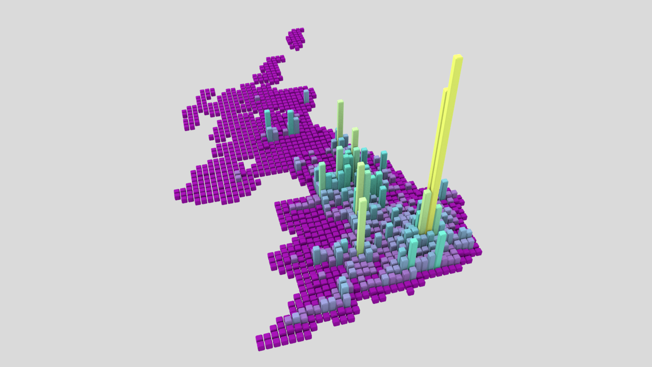
Visualizing OSM – amenity=pub in UK 1 | © Nikolai Janakiev, map data © OpenStreetMap contributors, ODbL
Mapping
- Jyri-Petteri Paloposki proposes
aeroway=highway_stripfor landing strips that are normally used as a highway, but can be closed either for a military exercise or emergency aeroplane landing. Proposal on wiki. - Have you always wanted a better way to add a racetrack? This proposal might be interesting for you.
- The proposal for more detailed tagging of saunas and hot baths sparked an international discussion on the tagging mailing list. There is a vote on the wiki until July 9th.
- Are you lost when it comes to indoor and underground mapping? Someone asked in the forum for help. There is a rendered indoor map available and the comprehensive wiki page can hopefully push you in the right direction.
Community
- OSM US is still looking for an executive director.
- Datendelphin proposes adding an icon for OSMF membership on user pages. The technical details are being discussed on GitHub.
- The 60,000,000th changeset was uploaded on June, 20th 2018 by user mkačer. The 50.000.000th was uploaded nearly a year ago on July 3rd, 2017.
- Heather Leson, from OSMF board, published a blog post asking for experiences with diversity issues in the OSM community. She named her efforts to raise awareness on gender issues in OSM as “Open Gender Monologues”. Heather Leson together with Kate Chapman, will host a session on this topic at the State of Map in Milan (July 28 – 30, 2018). There are a number of controversial comments below her blog post.
- The tagging mailing list is discussing (1, 2) the spin-off of the tagging templates from the Editor iD and the development as its own project. There are contributors who express their perspective around the tagging decisions made for iD editor.
- User mapeadora published a diary entry about the perception of gender equality in OSM. While the final results of a survey on this topic will be published later at the SotM in Milan, she already posted some preliminary results. 33 men and 24 women from 14 countries answered the survey. If you want that survey to become more relevant, the survey can be answered in 7 languages.
- The International Journal of Geo-Information published the paper “Mapping Urban Land Use at Street Block Level Using OpenStreetMap, Remote Sensing Data, and Spatial Metrics”.
- After a long process, the team of uMap Latam successfully migrated and updated the service avoiding the loss of the maps and the need for users to manually migrate their maps at UMAP Latam.
This instance of uMap hosts more than 1400 maps for Latin America and the world.
OpenStreetMap Foundation
- Since the preliminary agenda of the OSMF board meeting on June 21 included the non-public agenda item to discuss rules on the admission of regional representatives, Michael Reichert has asked the board to discuss these criteria with the members before they will be decided.
- The minutes of the meeting of the License Working Group on June 14th is now public. Among the topics on agenda, there were the new terms and conditions for openstreetmap.org usage.
- Updated Text: Martin Koppenhoefer pointed out that Facebook and Apple while using OSM data for their maps, do currently not attribute according to the OSMF Legal FAQ attribution clarification. As both companies are Corporate OSMF Members and members of the OSMF Advisory Board he suggested this could be an opportunity to talk about attribution with them.
Events
- FOSS4G Hokkaido was held in Sapporo, Japan on June 22nd and 23rd. The video of the Core day and Tweet summary is online. And some session’s slides are linked from the program table. OpenStreetMap was mentioned in some sessions.
- This year’s State Of The Map US will take place in Detroit, Michigan, from October 5th to 7th.
Humanitarian OSM
- OSM in Zambia has grown from a few mappers in 2016 to hundreds today. As HOT reports, microgrants from HOT and Nethope Device Challenge as well as funding from GIZ and World Bank allowed OSM Zambia to purchase mapping equipment for new contributors. The mapping activity includes the collection of baseline geodata as well as for the Lusaka Sanitation Program, aiming to prevent diseases such as cholera.
Maps
- The release of version 4.12.0 of the OpenStreetMap Carto stylesheet has been announced on the mailing list. The only major change was the removal of subpixel accuracy for areas. Minor changes include the rendering of
tourism=informationsubtypes and vertical objects rendering and tuning, and the rendering forplace=quarterandhistoric=city_gate.
switch2OSM
- The OpenStreetMap blog features a detailed article for potential new OSM data users. If you are planning to switch your maps/websites to OSM, make sure to give it a read!
Software
- Telenav joins Mapbox and Facebook by publishing their efforts about future of mapping driven by omnipresence of sensors, artificial intelligence, and machine learning. In the same blog post they launched a competition to improve their training data sets, detections and releasing three key components of their OpenStreetCam stack, namely the training set of images, machine-learning technology and the detection results.
- K_Sakanoshita updated his “Machi-aruki Map maker“. With this tool, you can create a map showing vectors in your favourite stroke and save them as PNG or SVG. The UI is Japanese, but it can be used all over the world. He explains how to use it on his blog.
Programming
- Nikolai Janakiev continues his data analysis articles with “Compare Countries and Cities with OpenStreetMap and t-SNE” where he takes a closer look at how to use the amenity distributions to compare and cluster countries and cities.
- [1] Nikolai Janakiev wrote a tool for visualizing OSM data through heat-maps using Blender and Python.
Releases
- Version 2.9.1 of the iD editor has been released.
amenity=shelterno longer impliesbuilding=yes, instead the preset now includes building as option. Besides a lot of preset changes and additions, two bug fixes, minor usability changes and a walkthrough change, the resolution of Bing Streetside was improved. - Version 3.2 of QGIS, codename “Bonn” (where the 16th QGIS developers meeting took place in 2016), has been released on June 24th. A visual changelog was also published.
OSM in the media
- The German IT newspaper “Netzwelt” published
 an article about the advantages of OSM over Google. The key argument, access to the raw data, was bolstered with an OSM-based study from a travel website about the greenest cities worldwide. (Hint: Reykjavík, Auckland and Bratislava are numbers 1 to 3)
 an article about the advantages of OSM over Google. The key argument, access to the raw data, was bolstered with an OSM-based study from a travel website about the
 Other “geo” things
- As reported (automatic translation), Google is updating its data for Germany. Although they improved the cameras on their cars last year, there are no plans to update the Street View images as the German data protection law prevents it according to a statement from Google. Instead they are collecting data for an improvement of street names, road geometries and POI data.
- The Swiss Federal Office of Topography is asking for help to georeference historical images of the country. Even if you can’t help, you may want to browse through over 50,000 historical images of Switzerland.
- StreetCred, created partly due to the shutdown of Mapzen, is estimating that there are 1 billion POIs across the world. The company announced that they want to build a marketplace to buy POI data from users that collect the data and sell it to companies. The collecting users will be rewarded with a blockchain currency called StreetCred token.
- ESRI has published 33 football related statistical maps under the title “The World Cup in 33 Maps”.
- Mapbox is celebrating this football World Cup season by hosting the World Map Cup challenge, which is a 4-part competition in June & July. One needs to sign up to compete over the next four weeks to make awesome maps and be eligible to win some cool prizes.
Upcoming Events
| Where | What | When | Country |
|---|---|---|---|
| London | Missing Maps Mapathon | 2018-07-03 |  |
| Stuttgart | Stuttgarter Stammtisch | 2018-07-04 |  |
| Mannheim | Mannheimer Mapathons (MAMAPA) | 2018-07-05 | |
| Bochum | Mappertreffen | 2018-07-05 | |
| Urspring | Stammtisch Ulmer Alb | 2018-07-05 | |
| Ise | 世古をマッピング!:伊勢マッピングパーティ | 2018-07-07 |  |
| Salt Lake City | Salt Lake City Mappy Hour | 2018-07-10 | Utah |
| Lyon | Rencontre mensuelle pour tous | 2018-07-10 |  |
| Munich | Münchner Stammtisch | 2018-07-10 | |
| Cologne | Köln Stammtisch | 2018-07-11 | |
| Berlin | 121. Berlin-Brandenburg Stammtisch | 2018-07-12 | |
| Sakai | 厄払い!オープンデータソン in さかい | 2018-07-14 | |
| Cologne Bonn Airport | Bonner Stammtisch | 2018-07-17 | |
| Lüneburg | Lüneburger Mappertreffen | 2018-07-17 | |
| Moscow | Schemotechnika 17 | 2018-07-17 |  |
| Karlsruhe | Stammtisch | 2018-07-18 | |
| Mumble Creek | OpenStreetMap Foundation public board meeting | 2018-07-19 | |
| Essen | Mappertreffen | 2018-07-21 | |
| Salt Lake City | Salt Lake City Outdoor Survey / Mapping | 2018-07-10 | Utah |
| Tokyo | 東京!街歩き!マッピングパーティ:第21回 増上寺 | 2018-07-21 | |
| Greater Manchester | More Joy Diversion | 2018-07-21 | |
| Milan | State of the Map 2018 (international conference) | 2018-07-28-2018-07-30 |  |
| Dar es Salaam | FOSS4G & HOT Summit 2018 | 2018-08-29-2018-08-31 |  |
| Buenos Aires | State of the Map Latam 2018 | 2018-09-24-2018-09-25 |  |
| Detroit | State of the Map US 2018 | 2018-10-05-2018-10-07 |  |
| Bengaluru | State of the Map Asia 2018 (effective date to confirm) | 2018-11-17-2018-11-18 |  |
| Melbourne | FOSS4G SotM Oceania 2018 | 2018-11-20-2018-11-23 |  |
Note: If you like to see your event here, please put it into the calendar. Only data which is there, will appear in weeklyOSM. Please check your event in our public calendar preview and correct it, where appropriate.
This weeklyOSM was produced by Anne Ghisla, Nakaner, Polyglot, Rogehm, Softgrow, Spanholz, Spec80, SunCobalt, YoViajo, derFred, jinalfoflia, k_zoar.