31/03/2020-06/04/2020
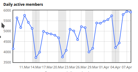
The trend observed by Pascal Neis in the week of 16 March seems to have been broken. 1 | © Pascal Neis © map data OpenStreetMap contributors
Mapping
- [1] Pascal Neis noticed that daily activity in OSM has been declining, but isn’t sure as to whether it should be attributed to: COVID-19 and people having more important things to do; less outside activity; or fewer active paid mappers. In his two Tweets he provided charts of daily active mappers and editor usage statistics for the past month, along with the raw data.
- Phyks asked whether a cycleway can be limited to mountain biking, as they felt that the documentation for
highway=cyclewayis more about city cycling. We are sure that one of the more than 80 answers in the mailing list thread has helped them with their query. - Ty Stockman suggests extending the tagging of medical facilities with
urgent_care=yes/no. However, the term ‘urgent care’ does not seem to match perfectly with what he meant. - Georg von der Howen came across a discussion on Reddit regarding the mapping of changed opening hours during the COVID-19 pandemic that he would like to bring to a broader audience. There are currently five tags with a
:covid19namespace that allow users to tag deviating information that applies only as long as the crisis lasts. In his opinion, the:covid19namespace can be applied toopening_hours,description,note,deliveryandtakeaway. The origin of these extensions seems to be in France where many places in Paris have already been tagged accordingly. - Pascal Neis has made another service available for mappers. On Twitter he announced the availability of a map that shows the latest edits per tile.
Community
- Ça reste ouvert, the map of places open during the COVID-19 lockdown, has collected opening hours in France for almost 20,000 places within three weeks.The French community collaborated with several other communities and has added new countries to the map: Germany, Switzerland and Austria (as ‘Bleibt offen’), as well as Spain and Andorra. Their GitHub repository provides an issue template to request coverage for your country.The French service provider TransWay has published a mobile app for iOS. Eric Afenyo is developing one for Android.
- Ed Freyfogle, from ‘OpenCage Data’ and ‘Geomob’, talked with Andy Allan, long-time OSMer and Geomobster, maker of OpenCycleMap, and founder of Thunderforest. They discussed building a bootstrapped geo business generally, and specifically the challenges of creating a business around OpenStreetMap.
- Austin Bell started a new OSM-related podcast named ‘Nodes and Ways’. In his first episode he interviewed Maggie Cawley, Executive Director of OpenStreetMap US.
- A week-long campaign took place in the Russian OSM community in early April (from 30 March to 5 April). It was dedicated to closing notes
 (automatic translation) and 48 participants closed almost 1500 notes during the week. However, more than 19,000 notes are still open around the territory of Russia.
 - Valery Trubin continued his series of interviews with OSMers. He spoke to Alexander Pavlyuk (automatic translation) about shooting orthophotos with planes and Maxim Dubinin (automatic translation), founder of NextGIS, about the quality of OSM data and why many people don’t trust it.
 (automatic
 Imports
- Rafael Avila Coya, an experienced mapper with a lot of experience importing to OSM, announced a series of imports as part of the Unite Maps Initiative.
OpenStreetMap Foundation
- Joost Schouppe from the OSMF board announced the start of OSMF’s Microgrants Committee.
- Michael Spreng, from OSMF’s Membership Working Group, published a proposal for a free OSMF membership for people who made a ‘sizeable contribution’ to the project. The suggestion is to grant a free membership to requesting mappers who have contributed on at least 42 calendar days in the last 365 days. You are asked to provide feedback by writing a comment to the blog post or mails to the OSMF mailing list thread, or to the Membership Working Group directly.
Maps
- Dave Bolger has produced an OSM-based map showing the 2km radius around your home. In Ireland you are limited to exercising within 2km of your home as part of the restrictions in place to combat COVID-19.
- Primera Edición reports (automatic translation) that the Province of Misiones, Argentina, has produced a map allowing users to visualise which essential services are closest, so as not to violate the current isolation decree. The map was created using uMap.
- The Heidelberg Institute for Geoinformation Technology (HeiGIT) at Heidelberg University, has developed, together with Markus Ries from the Center for Pediatrics and Adolescent Medicine, University Hospital Heidelberg, a Map of COVID-19 Clinical Trials.
 (automatic
 switch2OSM
- The Russian project ‘Historical memory of the cities‘ is a website where anthropologists and sociologists post fragments of different people’s oral stories about their home, neighbourhood or city. It uses OSM as a basemap.
Open Data
- The British Geospatial Commission announced that unique identifiers for addresses and streets will be available as open data under the Open Government Licence from July 2020. Owen Boswarva has tweeted, as a thread, a preliminary detailed analysis. The actual addresses remain proprietary and any associated geometries will be generalised.
Software
- AnyFinder, the POI finder app for iOS, has added support for the current five
:covid19namespaced tags. The developer has also created a special ‘COVID19’ category within the app’s ‘Events’ section, where users can quickly search for restaurants that are now closed but offer takeaway services during the pandemic, for shops that now offer home delivery, or for places with additional information about their operation during the pandemic. - HeiGIT increased the API quota for the Openrouteservice multi-vehicle route optimisation endpoint. The optimise endpoint of Openrouteservice is based on the Vroom engine by Julien Coupey.
Releases
- JOSM has progressed to the stable version 20.03. The new version brings support for the Arabic language and support for Eastern Arabic(-Indic) and Khmer numerals, along with multiple other minor enhancements and fixes.
Did you know …
- … about the site onosm.org with the help of which companies can ask to have themselves added to OSM?
Other “geo” things
- Google is using anonymised location data to produce community mobility reports for public health officials, to help as they make critical decisions to combat COVID-19. Jen Fitzpatrick’s blog post gives some background to the project and the reports are available here.
- Esri, a major international provider of proprietary geographic information systems software, featured the availability of a new set of feature layers in ArcGIS Online created with OSM live data, in a blog post.
Upcoming Events
Many meetings are being cancelled – please check the Calendar on the wiki page for updates.
Note: If you like to see your event here, please put it into the calendar. Only data which is there, will appear in weeklyOSM. Please check your event in our public calendar preview and correct it, where appropriate.
This weeklyOSM was produced by Polyglot, Rogehm, SK53, Silka123, SunCobalt, TheSwavu, derFred, geologist, ghowen, osmapman.
Hi Pascal is right, since lockdowns are announced, the number of surveys will suffer as well, like mine no actuall survey made last weeks and more weeks to come. Greetz