23/04/2019-29/04/2019
Châteaux et palais en Suisse et alentours (Allemagne, France et Italie). Combinaison de OpenStreetMap+Wikidata+Wikimedia Commons+Wikipedia 1 | Données cartographiques © Contributeurs OpenStreetMap, ODbL
Cartographie
- Vainqueur du prix « Greatness in Mapping » en 2018, Tshedy (Mats’eliso Thobei), a organisé un mapathon de 24 heures au Lesotho vendredi 26 avril. Sur Twitter, elle remercie tous les participants pour le soutien et les encouragements.
- Colin Blackburn rapporte les résultats de son enquête planifiée depuis longtemps sur une zone cartographiée aux Pays-Bas avec « Clothing Optional », et ne trouve aucune preuve sur le terrain pour cette description.
- Le vote pour
landcover=barren, un attribut pour les zones sans végétation – sol nu – a démarré mais le vote ne se déroule pas bien au moment de la rédaction de ce message. Peter Elderson en a probablement donné la raison dans un commentaire sur son vote : « … votre raisonnement ne correspond pas au point de vue de la majorité des cartographes OSM ». - Le vote a commencé pour la clé
golf_cart=*, et vise à indiquer les restrictions d’accès imposées aux voiturettes de golf et petits véhicules similaires à vitesse réduite. - La distinction entre
waterway=riveretwaterway=canaln’est pas aussi facile qu’on pourrait le croire. Une discussion sur les différences a été lancée par Dave F, qui estime que des contributeurs ont incorrectement spécifié les sections canalisées aux portes des écluses le long des rivières avec l’attributwaterway=canal. - Joseph Eisenberg a ajouté au wiki une section sur les tracés non vérifiables tels que
natural=bay,natural=strait, etplace=*. Cependant, tous ne s’accordent pas sur les changements apportés comme l’indique la réponse de Tobias Knerr. - Au lieu de démarrer un processus de proposition, Joseph Eisenberg est passé directement à l’étape de rédaction d’une page de wiki pour
natural=mountain_range, un attribut déjà utilisé plus de 600 fois par 80 contributeurs différents. - Joseph Eisenberg a créé deux nouvelles pages de proposition, la première pour
natural=mesaet la seconde pournatural=butte. Une mesa est un petit plateau à sommet plat et aux versants abrupts. Une butte est similaire mais plus petite. - Jan S a soumis une version allégée de la proposition récemment refusée concernant les infrastructures de police. La nouvelle proposition concerne uniquement la clé
police=*. - fanfouer a rédigé une proposition pour améliorer la description des infrastructures électriques dédiées aux stations ferroviaires (
substation=traction) et demande des retours.
Communauté
- Fanevanjanahary et SeverinGeo ont partagé un tweet et un moment Twitter concernant #ActionOSMMG2019 : deux semaines de formation à OSM et en géomatique libre organisées à Antananarivo (Madagascar) auprès de différents publics malgaches et comoriens (étudiants, professionnels du privé et du public) avec le concours de membres des communautés OSM malgache et togolaise et grâce au soutien de la Direction Économique et Numérique de l’Organisation Internationale de la Francophonie. Au cours de ces ateliers, un mapathon étalé sur plusieurs jours a été réalisé autour du lac Itasy à la demande de la coopération décentralisée Région Itasy/Nouvelle Aquitaine, qui est documentée dans les activités d‘édition dirigées sur le wiki OSM, comme le demande désormais la fondation OSM.
- Les données sur le littoral et la couverture glaciaire, jusqu’ici hébergées par openstreetmapdata.com, ont été déplacées vers osmdata.openstreetmap.de. Dans un article, Jochen Topf donne des détails sur ce transfert.
- La signification de park dans
leisure=parket dansboundary=national_park, ainsi que la distinction entre différents types de parcs est la source d’une discussion approfondie sur la liste Talk-us. - Jinal Foflia, de Grab, a mentionné dans un article le travail d’une équipe de Grab en Thaïlande qui a contribué des images sur Mapillary dans la région de Chiang Mai, qui est maintenant couverte à 82 % avec plus de 1667 km de routes. La mise à jour devrait être complétée d’ici la fin du mois.
- Dans le cadre du projet Opencities Africa de la Banque Mondiale, Potentiel 3.0 et OSM-RDC ont travaillé avec OSFAC (Vidéo) pour trouver des solutions innovantes contre l’érosion et les inondations pour améliorer la situation des collectivités locales à Kinshasa. Ce travail en cours depuis juin 2018 a utilisé de nombreuses approches et outils : contributions participatives, drones, formation à la collecte de données avec les administrateurs locaux et les citoyens à l’aide de smartphones et de tablettes, groupes de travail sur l’analyse cartographique et l’identification des tâches, outils d’analyse de qualité pour évaluer les contributions.
- La suppression des pages du wiki n’est toujours pas encadrée. La proposition d’une politique de suppression pour le wiki OSM a échoué. L’argument principal en défaveur de la proposition a été le poids bureaucratique qui aurait résulté de cette politique, bien que certains des détracteurs concèdent le besoin de certaines règles. Comme le temps passe et que le nombre de pages obsolètes grandit, la question pourrait réapparaître. Dans notre dernier numéro, nous parlions d’une plainte à propos d’une page wiki supprimée.
- flowolf a commencé avec son collègue à créer un annuaire d’entreprises gratuit basé sur OSM (yellowosm). Il a été présenté
 lors d’une conférence au Grazer Linuxtage 2019. Actuellement, la carte ne montre que les entreprises autrichiennes.
 lors d’une conférence au Grazer Linuxtage 2019. Actuellement, la carte ne montre que les entreprises autrichiennes.
Événements
- Adam Steer partage la proposition de programme du FOSS4G SotM Oceania, qui aura lieu du 12 au 15 novembre 2019 à Wellington en Nouvelle-Zélande et demande des commentaires avant la fin du mois de mai, pour le début de l’appel à participation.
OSM et l’humanitaire
- Dans un billet de blog publié sur le site de HOT, Lauren Bateman, de la Croix-Rouge américaine, explique comment les données et les cartes fournies par HOT et OpenStreetMap ont aidé leur travail après le cyclone Idai.
- L’Université du Luxembourg et Médecins Sans Frontières organiseront un mapathon le 23 mai 2019 pour soutenir les efforts humanitaires de MSF.
- Le procès-verbal de la réunion du conseil d’administration de HOT du 18 avril 2019 est maintenant disponible.
- La communauté MapSwipe et l’Institut de technologie de l’information géographique de Heidelberg ont commencé à travailler sur une extension MapSwipe qui permettra aux utilisateurs de trouver des changements en comparant deux images satellites pour aider les efforts de cartographie humanitaire.
- Le GIScience Research Group de l’Université de Heidelberg tiendra une session intitulée Usage and Analyses of OpenStreetMap for Development à la 11ème Conférence sur les technologies de l’information et des communications au service du développement (ICT4D), qui se tiendra du 30 avril au 3 mai 2019 à Kampala en Ouganda.
Cartes
- Jochen Görtler et ses collaborateurs ont reçu le prix « best paper » lors de la conférence Pacific Visualisation pour leur travail intitulé Stippling of 2D Scalar Fields.
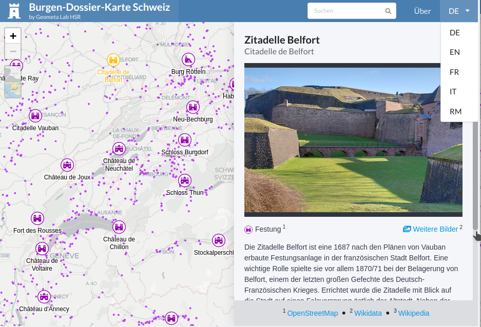
- [1] Stefan Keller de la Haute École Spécialisée de Rapperswil a publié la carte web la plus complète des châteaux et palais de Suisse s’étendant aux pays voisins (Allemagne, France, Italie) – jusqu’au château de Neuschwanstein. L’application multilingue combine OpenStreetMap avec Wikidata, Wikimedia Commons (images) et Wikipédia. Le code source du projet est disponible sur GitLab.
- Le site historic.place propose désormais une carte des fortifications basée sur les données Wikimedia dédiées .
- Contre toute attente, l’application officielle du marathon de Londres utilise directement les serveurs de tuiles d’OpenStreetMap, générant une charge difficile à absorber. Voir la politique d’utilisation des serveurs et switch2osm.org pour la mise en place d’une infrastructure dédiée.
Données ouvertes
- L’antenne allemande de la Fondation Open Knowledge décrit les changements apportés par les nouvelles directives européennes 2018/0111: Réutilisation de l’information du secteur public, qui facilitera l’accès à l’information publique. Cependant, l’ouverture de l’Union Européenne reste loin derrière la licence en domaine public garantie par le domestic copyright protection waiver du gouvernement fédéral états-uniens.
Licences
- Oracle modifie son modèle de licence pour l’environnement de développement Java. L’impact sur l’utilisation de JOSM est abordé sur le forum allemand.
Applications
- Development Seed a créé osm-coverage-tiles, qui visualise les informations liées aux infrastructures dans OSM, notamment les bâtiments et les routes. L’objectif est d’améliorer la validation des résultats d’algorithmes d’apprentissage. Pilar Gabriela Serrano Quispe donne de plus amples informations sur medium.com.
Développement
- Pierre Béland a publié ses scripts PostGIS OQ_Analysis qu’il a utilisés dans trois analyses de la qualité de la géométrie des bâtiments.
Nouvelles versions
- L’équipe de développement de JOSM a publié la nouvelle version 15031 qui corrige un bug, incorpore dans le menu « Plus d’outils » l’ancien greffon download_along et d’autres corrections et améliorations listées dans le changelog.
Connaissez-vous…
- … la description des horaires disponibles aux arrêts de transport public ? L’attribut
departures_boarddécrit une fiche horaire traditionnelle, tandis quepassenger_information_displayconcerne les équipements électroniques dispensant des informations en temps réel. - … la possibilité de cartographier rapidement les relations pour les interdictions de tourner dans Vespucci et iD ?
.gif)
.gif)
OSM dans les médias
- Le Saarbrücker Zeitung mentionne Carsten Grammes, président d’une association qui s’intéresse au passé minier de la Sarre. Il combine deux passions avec des excursions dans de vieux tunnels et son travail sur la carte historique Historic.Place, et organise maintenant des visites guidées de la mine d’aventure de Velsen.
- Ce billet de blog d’apnews.com explique le travail sur la combinaison de données de l’U.S. Census Bureau, de Cal Fire et d’OpenStreetMap pour l’étude des routes d’évacuation dans les zones à risque pour les incendies en Californie.
Autres sujets géographiques
- Daniel Huffman se remémore avec regret le tracé d’itinéraires schématisé qu’il avait mentionné dans un ancien article.
- Far & Wide présente 45 cartes étonnantes du monde entier avec des faits et chiffres remarquables.
- Un article paru dans le magazine Wired explique la différence entre les systèmes d’encodage de coordonnées et les adresses concernant les actions menées à Porto Rico après le passage de l’ouragan.
- Le sprint de développement de la communauté OSGeo aura lieu du 14 au 17 mai dans le Minnesota.
Événements à venir
| Où | Quoi | Quand | Pays |
|---|---|---|---|
| Maynooth | Maynooth University | 2019-05-04 |  |
| Taipei | OSM x Wikidata #4 | 2019-05-06 |  |
| Toronto | Toronto Mappy Hour | 2019-05-06 |  |
| Essen | Mappertreffen | 2019-05-07 |  |
| Munich | Münchner Stammtisch | 2019-05-08 | |
| Salzbourg | Maptime Salzburg – Mapathon | 2019-05-08 |  |
| Wuppertal | Wuppertaler Stammtisch im Hutmacher 18 Uhr | 2019-05-08 | |
| Berlin | 131. Berlin-Brandenburg Stammtisch | 2019-05-09 | |
| Ivrée | Incontro Mensile | 2019-05-11 |  |
| Kyōto | 京都!街歩き!マッピングパーティ:第8回 柳谷観音 | 2019-05-12 |  |
| Rennes | Réunion mensuelle | 2019-05-13 |  |
| Bordeaux | Réunion mensuelle | 2019-05-13 | |
| Zurich | OSM Stammtisch Zurich | 2019-05-13 |  |
| Lyon | Rencontre mensuelle pour tous | 2019-05-14 | |
| Salt Lake City | SLC Mappy Hour | 2019-05-14 |  |
| Hambourg | Hamburger Mappertreffen | 2019-05-14 | |
| Toulouse | Rencontre mensuelle | 2019-05-15 | |
| Karlsruhe | Stammtisch | 2019-05-15 | |
| Prague | Wikimedia Hackathon 2019 | 2019-05-17-2019-05-19 |  |
| Reading | Reading Missing Maps Mapathon | 2019-05-21 |  |
| Aéroport de Cologne/Bonn | Bonner Stammtisch | 2019-05-21 | |
| Derby | Derby pub meetup | 2019-05-21 | |
| Lunebourg | Lüneburger Mappertreffen | 2019-05-21 | |
| Lübeck | Lübecker Mappertreffen | 2019-05-23 | |
| Montrouge | Rencontre mensuelle de Montrouge et alentours | 2019-05-23 | |
| Montpellier | State of the Map France 2019 | 2019-06-14-2019-06-16 | |
| Angra do Heroísmo | Erasmus+ EuYoutH_OSM Meeting | 2019-06-24-2019-06-29 |  |
| Minneapolis | State of the Map US 2019 | 2019-09-06-2019-09-08 | |
| Édimbourg | FOSS4GUK 2019 | 2019-09-18-2019-09-21 |  |
| Heidelberg | Erasmus+ EuYoutH_OSM Meeting | 2019-09-18-2019-09-23 | |
| Heidelberg | HOT Summit 2019 | 2019-09-19-2019-09-20 | |
| Heidelberg | State of the Map 2019 (international conference) | 2019-09-21-2019-09-23 | |
| Grand-Bassam | State of the Map Africa 2019 | 2019-11-22-2019-11-24 |  |
Note: Pour que votre événement apparaisse dans l’hebdoOSM, ajoutez-le au calendrier.
Cet hebdoOSM a été préparé par Nakaner, PierZen, Polyglot, Rainero, Rogehm, SK53, SeverinGeo, SunCobalt, derFred, jcoupey, jinalfoflia, roptat.