30.09. – 06.10.2014

Talk, Forum, Wiki & Blog
- In the OpenCageData blog you can read an interview with a mapper who speaks mainly about mapping in crisis areas.
- User jgruca suggests to use relations for sculptures with multiple pieces.
- This advertisement on the side of a tram in Toronto features a large map from OpenStreetMap!
- One of the oldest OSM Live Tracker is back.
- Call for papers: The CFP für die AAG 2015 (Association of American Geographers) is looking for OpenStreetMap Studies: Research Perspectives on a Decade of OSM.
- User Malenki returned from hiking with Mapillary and talks about the results and his experiences.
- Mapbox describes extensively how they identified areas that need better tracking in OpenStreetMap.
- User Dakon wrote a program to show fire hydrants, water tanks and emergency access points.
- A blogpost about the “Berlin, Berlin Bug”.
- Two MapRoulette challenges completed! (via Twitter)
- An OpenStreetMap community campaign to donate money to the Ada Initiative.
- Peter Richardson blogs about 3D buildings in OSM.
- User Tallguy talks about the Mapthon in London.
Humanitarian OpenStreetMap Team
- A Presentation shows how OSM contributes to handling the Ebola-crisis and the Typhoon Haiyan (Yolanda).
Maps
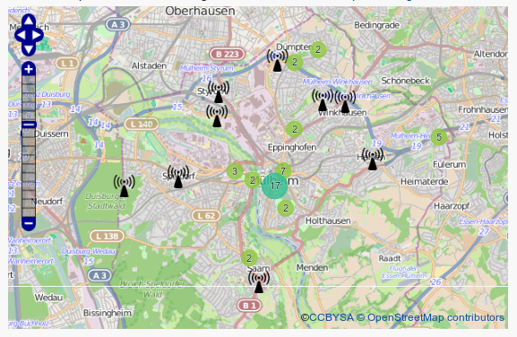
- [1] The city of Mülheim an der Ruhr shows open Wlan-Hotspots on an OSM map.
- Katy DeCorah replaced the boring markers by Emojis.
- mapcil is a new service for individual information-overlays, developed by Küstenschmiede GmbH, the producers of einsatzkarte.de
- Half of the mankind lives in this circle.
Tagging
- Marek Strassenburg-Kleciak is pondering how to map frontages in OSM when they have different colours at different heights.
Did you know…
- … that Pocket Earth for iOS uses OSM-data (even offline 😉 ). (via@TheFive_osm)
Programs
- OSMfocus is a new Android app to show detailed data on OSM objects.
- Nominatim released the new version 2.3.
- OpenDroneMap is a free and open source software for post-processing from unreferenced overlapping photos to an unreferenced point cloud, dedicated to “civilian (and humanitarian?) UAS/UAV”.