20/02/2025-26/02/2025

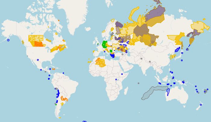
[1] Emergency and weather alert map view from OSM Hack Weekend | Map data © OpenStreetMap Contributors.
Comunidade
- O Clube OSM da ENSTP está de volta! E você é convidado(a] a participar. No programa, estão: formação técnica, conferências temáticas, projetos de mapeamento e muitas outras surpresas… Esta ação marca o início das atividades da comunidade OSM da Ecole Nationale Supérieure des Travaux Public (ENSTP)
>
, em Cameroon.
- Jean-Christophe Becquet realizou uma apresentação intitulada Encouraging Contributions in Your Area (ou Encorajando contribuições na sua área) no AlpOSS
>
, o evento de software livre e de código aberto, sediado em Isère (França). Com base nas experiências do ecossistema OpenStreetMap, em várias regiões e temas, esta apresentação descreve uma metodologia para promover o envolvimento, em torno de um patrimônio digital.
Eventos
- [1] Você pode explorar
>
os resultados do OSM Hack Weekend, organizado pela Geofabrik em Karlsruhe, Alemanha, que discutiu e trabalhou em questões relacionadas com Itinerário, trânsito e emergência, ou alerta meteorológico, envolvendo o OSM.
- Ainda pode registar-se
>
no 5º Congresso anual de Capítulos e Comunidades Locais do OpenStreetMap (5th Annual OpenStreetMap Local Chapters and Communities Congress), que decorrerá online, em 15 de março de 2025. Todos podem participar para conhecer as novidades e socializar com as demais comunidades de mapeadores(as) do OpenStreetMap.
Educação
- Você pode explorar
>
os resultados do OSM Hack Weekend, organizado pela Geofabrik, em Karlsruhe (Alemanha), que discutiu e trabalhou em questões relacionadas ao itinerário, trânsito e emergência, ou alerta meteorológico, envolvendo o OpenStreetMap. Como destaque, Raymond Lay apresentou
>
o QMap, um plugin recém-lançado para o QGIS, mantido por Nathan Woodrow, que permite aos usuários comparar vários mapas dentro da plataforma, utilizando uma série de técnicas de visualização.
Pesquisas com OSM
- Peschanski, Jurno e Hilsenbeck Filho, do Wiki Movimento Brasil, publicaram um artigo de acesso aberto na revista científica Texto Livre (ou Open Text), apoiada pela UFMG (Brasil), discutindo alguns casos de sucesso de soluções abertas em projetos de extensão digital. O uMap das estradas e pontes interditadas ou destruídas, criado durante o desastre do Rio Grande do Sul de 2024, foi mencionado. Os dados das pontes e rodovias problemáticas foram mapeados no OpenStreetMap por Fernando Trebien (OSM RS) e outros; e o uMap foi criado por Raquel Dezidério Souto (IVIDES.org e YouthMappers UFRJ).
Mapas
- hflan (na Community OSM) propõe-nos localizar Golfo de OpenStreetmap, utilizando o MapQuest. Sabe onde fica o Golfo de Have a Dream?
OSM em ação
- OpenStreetMap em estado selvagem. Há algumas semanas, o condado francês de Doubs publicou sobre um dos seus novos recrutas, Adrien Zhang. Alguns colaboradores viram o logótipo do OSM na sua secretária. O condado também usa
>
uma instância do InfoRoute para compartilhar informações de trânsito, também mostrada na tela do seu ambiente de trabalho, contando com o OSM como camada base (base layer).
Dados abertos
- Como noticiado anteriormente, o OpenLandMap é fornecido pelo OpenGeoHub
>
, apresenta muitas camadas temáticas e utiliza o OpenStreetMap como uma das camadas base (base layer) disponíveis. O projeto baseia-se em dados abertos e softwares livres, como Geoserver, React, plumber R e OpenLayers. A novidade é que, desde este ano de 2025, inclui imagens aéreas Bing.
- Kailash Nadh e Madhav Pai destacaram a importância do OpenStreetMap como um bem público e componente chave da infraestrutura pública digital na sua recente palestra intitulada Open Data in Mobility. A sessão ocorreu em 21 de fevereiro de 2025, durante o segundo dia do Namma raste, uma exploração aprofundada da mobilidade urbana de Bengaluru, de três dias, que reuniu especialistas, tomadores de decisão e cidadãos, a fim de moldar um futuro de transportes mais seguro e sustentável.
Programas
- Foi reaberto
>
o tíquete JOSM #23913, sobre o recente problema com as imagens Bing no JOSM. O usuário RollTideRoll_asdfjkll, relatou que as imagens do Bing estão inacessíveis no editor. Mikel Maron confirmou o contato em curso com a Microsoft, de modo a saber se todos os editores do OSM poderiam usar a chave atualmente utilizada pelo editor iD. Até o momento da publicação deste artigo, a Microsoft ainda não respondeu.
- David Karlaš atualizou
>
o seu script, que adiciona botões úteis ao website do OpenStreetMap. O script atualizado inclui agora links diretos para o OSMCha e o editor level0 e funciona com o layout recentemente atualizado do site do OpenStreetMap.
- Você sabia que Lucas Jellema publicou
>
um pequeno guia para usar o CartoDB e o OpenStreetMap no QGIS?
Você sabia que…
- … estão disponíveis mais de mil conjuntos de dados OSM no data.europe.eu, o portal oficial dos dados europeus?
Outros assuntos “geo”
- O utilizador do Reddit Throwboi321 conduziu
>
uma análise espacial para investigar a hipótese de que a qualidade do kebab diminui perto das estações ferroviárias. Ao integrar dados do OSM (relativos a redes de navegação e localizações de estações ferroviárias) com avaliações do Google Maps, como indicador de sabor, o objetivo era avaliar a validade da hipótese.
- Pode conhecer
>
os destaques do candidato a lançamento (release candidate) do QGIS 3.42 (Münster).
- Burghardt, Demidova e Keim editaram
>
um livro de acesso livre, dedicado à informação geográfica voluntária (volunteered geographic information, VGI), que foi publicado pela Springer Nature, em 2024, e inclui artigos resultantes do programa VGIscience
>
, desenvolvido pelo Institut für Kartographie da Technische Universität Dresden (Alemanha).
Próximos eventos
Nota: Quer ver seu evento publicado aqui? Então adicione-o no OSM Kalender calendário. Apenas os dados que forem inseridos lá aparecerão no weeklyOSM.
Este semanárioOSM foi produzido por AdrieleSBernardo, MatthiasMatthias, Raquel Dezidério Souto, TheSwavu, derFred.