02/09/2016-02/15/2016
Mapping public transit in Bangalore [1] | additional Info Blog by Sajjad Anwar
Mapping
- Christoph Hormann added more images for mapping in OSM.
- A video tutorial gives an overview of all elements to map in the 61,000 Townlands in Ireland.
- Martijn van Exel informs about a (youtube) video tutorial about the online service improve-osm.org.
- A video about the progress of OSM in Mexico 2006-2015.
- User Arun Maharajan wrote a diary article asking for feedback on how to go about mapping smaller and lesser known businesses in slums of Mumbai. The aim is to establish contact with people interested in this subject and this will be maybe help small businesses improve their earnings.
- There is a proposal to stimulate a transition of the feature tag
Jewellery_shopfrom the American English termshop=jewelryto the British termshop=jewellery. - The voting for the Government offices tag, office=government proposal has started.
Community
- Christoph Hormann reports about a survey for Copernicus data users. He notes that, the survey is especially directed to small businesses and even hobbyists.
- Mapper in the Spotlight: dkiselev (Russia)
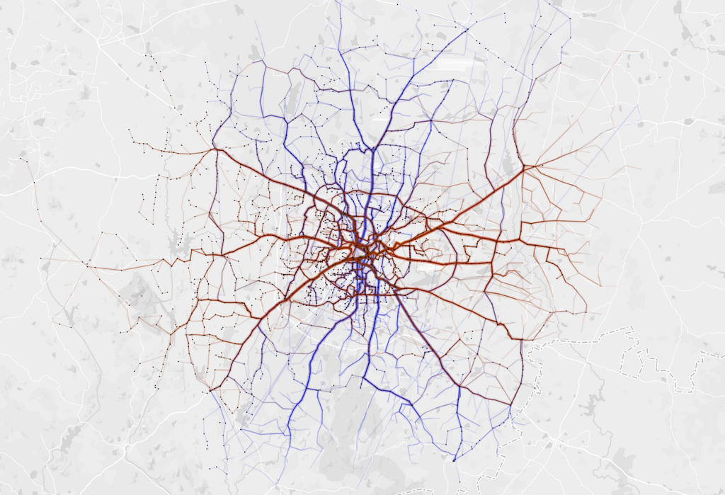
- [1] Sajjad Anwar from Mapbox wrote a blog on Mapping public transit in Bangalore which depicts routes taken by buses. Buses being the most popular mode of transport in Bangalore, India.
- ‘Targeted Editing – Tailgate Mania‘, a blog by Mapzen encourages people to add parking areas, parking aisles and access points to OpenStreetMap.
- UK 2016 Q1 Mapping Marathon:
Robert Wittaker summarises: Schools Mapping Progress Tools and Mappa Mercia describes « How to map a school in OpenStreetMap« .
OpenStreetMap Foundation
- Frederik Ramm added the preliminary financial numbers for the 4th quarter 2015.
Events
- As part of activities in observance of Saint Lucia’s 37th Independence Anniversary on February 22, 2016, the Government of Saint Lucia, through the Ministry of the Public Service, Information and Broadcasting will be hosting a national Mapathon on Sunday, February 28th, 2016, from 9:00am-5:00pm at the Derek Walcott Square in Castries.
Humanitarian OSM
- An article speaks about how volunteer-provided local information as in OSM helps individuals and humanitarian efforts to fight the spread of diseases.
Maps
- Adam Franco published a tool, Curvature, which analyzes the geometry (curve radii) of roads in OSM and produces color-coded world-wide KML overlays that motorcyclists and other driving enthusiasts can use to identify the most twisty roads and plan trips. Incomplete coverage of surface=* tags on road ways is a challenge in some regions as small unpaved roads are often the twistiest. To help improve the OSM data, ID and JOSM-control links are provided for each road allow users to quickly jump to un-tagged ways.
- Freifunk is a non-profit initiative to establish and operate a free wireless network in Germany. (additional automatic translated information). The community publishes the « access points » on an OSM map.
- User toc-rox announces the next release of Freizeitkarte-Android. The new added features are to be tested in a beta campaign. Release is planned for march 16th.
- As a non-profit organization, OpenWines gather and share genuine open-data resources about wines. They also publish maps and data visualizations about wines.
- Transportr is an open-source and non-profit android app developed by people around the world to make using public transport as easy as possible wherever you are.
switch2OSM
- A new tutorial about using OSM inside the X-Plane flight simulator has high view-counts.
Open Data
- Canton of Zürich allows the OSM community to use a WMS offering leafless aerial imagery (resolution 10 cm) from early spring 2014.
Licences
- Steve Coast writes on the US mailing list that he found out that some law students are investigating a possible license change. Steve requires openness and transparency on the osfm-talk mailing list and also intends to share a « full briefing document » with the community.
Software
- Some days ago Boundaries Map 4.0 with many new features has been released.
- A blog by Geofabrik writes about the new features of the OSM Inspector Address View.
- ivanatora reports about a recently developed game, based on OSM. He is still looking for solutions for some technical issues.
- Nakaner reports in his diary about a solution about a quite strange GUI error in JOSM when used in Debian/Ubuntu.
- The Wikimaps Wikimedia Commons Warper project has recieved an Individual Engagement Grant for 2016.
Programming
- Andrew notes that we’re approaching 4 billion nodes. 32 bit unsigned integers will not be useable for storing node IDs soon. 32 bit signed integers have been too short since 9. February 2013.
- Mauro Moreno has developed a Silex wrapper for the OpenStreetMap API.
- OSM-Foundation has published a blog posting about the last Google Summer of Code 2015
- OpenStreetMap will apply again for this year’s Google Summer of Code. Mentor organizations can apply by 19th February. Google will announce the accepted organizations on 29th February.
- Mapillary has published the javascript library named mapillary-js as opensource, Read one more blog about it. With this library you can embed Mapillary images in your websites.
- Littlebtc writes how PostGIS 2.2 makes it easy to group nearby bus stops.
Releases
Software Version Release Date Comment Maps.me iOS 5.6 2016-02-08 – Basecamp Mac 4.6.1 2016-02-09 – Atlas 1.2.2 2016-02-11 Updated map engine, various improvements Locus Map Free 3.15.3 2016-02-11 Bugs fixed PostgreSQL 9.5.1 ff 2016-02-11 Security update release Basecamp Windows 4.6.2 2016-02-12 Please read info Mapillary for Android 1.7.5 2016-02-12 fix bugs in camera map and Facebook auto sign
Did you know …
- … the CoffeeMap « cup of coffee » from Hamburg, realised with OSM and the OSM-Plugin from Mika?
- … A discovery to make Einstein proud? You can discvover LIGO Hanford and LIGO Livingston on OSM. LIGO = Laser Interferometer Gravitational-wave Observatory.
- … the website, with software products who are important around OSM? Recent version number, release date and availibility on different OS are listed.
- … the video, where Emrah Kutlu talks about indoor visualization and routing using OSM based vector tiles at MentzDV?
Other “geo” things
- See an article at vox.com about « The risk of an unintended war with Russia in Europe, explained in one map« .
Upcoming Events


Note: If you like to see your event here, please put it into the calendar. Only data which is there, will appear in weeklyOSM. Please don’t forget to mention the city and the country in the calendar.
This weekly was produced by Nakaner, Peda, Rogehm, TheFive, derFred, escada, jinalfoflia, mgehling, stephan75, wambacher, widedangel.
Is the http://www.improve-osm.org developer aware that they are blocked in EasyPrivacy, due to userreport.com …