21/01/2020-27/01/2020
Fernão de Magalhães’ Circumnavigation Voyage commemorate the 500th anniversary on OSM 1 | © CMETOC | © map data OpenStreetMap contributors
Mapping
- The European Water Project, a collaboration between Wikimedia Suisse and OpenStreetMap, collects photos of drinking water wells or springs and makes these photos available on Wikimedia Commons and in OpenStreetMap. A wiki page describes how to do it in English, Deutsch, Español, Français, Italiano and Nederlands. On the talk-fr mailing list, Stuart Rapoport from the European Water Project said (automatic translation) that Stefan Keller recommends the tag
amenity=drinking_waterinstead ofamenity=fountainanddrinking_water=yes. This mail is followed (automatic translation) by a discussion. - Cascafico Giovanni is interested in active volcanoes and has created an overpass query to find them and compared the result with infrared data from Sentinel-2. He wonders what the criteria for
volcano:status=activeare, as most of these volcanoes don’t have an infrared signature. - Thibault Molleman questions the existing tagging of fuel types at petrol (gas) stations, as usage numbers don’t reflect the changes made to the EU naming scheme in 2018.
- The voting for
amenity=give_box, an amenity where you can share various types of items freely, has started.
Community
- Hot on the heels of the upcoming LGBQT+ mapathon in Cebu City, which we reported two weeks ago, Mikko Tamura reports on a similar activity which was recently hosted by the Geography Department of University of the Philippines Dilman. The mapping party, held on 11 January, was organised by MAP-BEKS. Over 600 health-related facilities were identified where more data needs to be collected, and 150 were either added or updated on OSM
- Board elections are underway for OSM-US. A couple of candidates have written manifestos or position statements on their OSM Diaries: Minh Nguyen, and Daniela Waltersdorfer (DW2515 on OSM). Others are available via the wiki.
OpenStreetMap Foundation
- In a blog entry titled ‘Diversity in OpenStreetMap, Seeking your help on ideas for the Foundation’ Mikel Maron reports about the current discussion at the OSMF board on diversity and the idea of forming a Diversity Working Group.
Events
- OSM and OSGeo/FOSSGIS will be represented in a separate area at the AGIT 2020
 (automatic translation), Austria’s largest applied geographic information event. The event, for which volunteers are still being sought (automatic translation), will take place from 8 to 10 July 2020 in Salzburg, Austria.
 (automatic
 Humanitarian OSM
- HOT is looking for a location for the HOT Summit 2020. The organisation surveyed its followers on Twitter and got in touch with the OSM SotM Working Group.
- Heidelberg University’s GIScience Research Group blogged about an analysis of the activity in mapping the Rohingya refugee camps, in Bangladesh, by using the potential of the OpenStreetMap History Data API.
Maps
- Downloads from Planet OSM are currently rate limited to 400 kB/s. Grant Slater explained the background to this change and suggested that people make use of a mirror for full speed downloads.
- Mark Lester presented BuzMap, an interesting map that displays the services, and related data, that run on private railways and FlixBus roads.
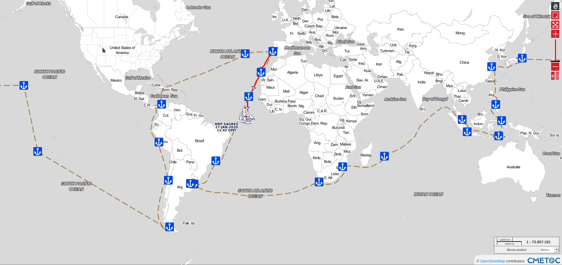
- Training Ship NRP Sagres (automatic translation) began a voyage of circumnavigation to commemorate the 500th anniversary of the Portuguese navigator Fernão de Magalhães‘ Circumnavigation Voyage. The voyage will last about 1 year and the ship will only return to Portugal in January 2021. The Portuguese Navy has created an online map for the public to follow the voyage. Excellent choice of base map!
- Cartonumerique (automatic translation) critiqued some of the visualisations of the Coronavirus outbreak, where some representations are at the country level with red colours. Various other visualisations, including CNBC’s Tableau visualisation (data collected by the Johns Hopkins University’s Center for Systems Science and Engineering, USA), let the viewer better track the Coronavirus spreading around the world, using various sized circles to show intensity – partly at the province or city level.
 (automatic
 Open Data
- The state of Brandenburg has released several hundred datasets with basic geographic data, free of charge and for any use. Previously the data was available only with restrictive licences and for significant fees.
- The Open Knowledge Foundation announced their mini-grant scheme for 2020.
Programming
- Daniel Patterson announced Mapbox’s decision to shut down the hosting of router.project-osrm.org and asked on the OSRM-talk mailing list if someone would volunteer to take over the task.
- Harmut wrote on his blog about an issue he uncovered while implementing an area bounds feature for MapOsmatic.
Releases
- The OsmAnd team updated the Online GPS Tracker to version 0.8. The new version makes location sharing easier, comes with a widget, improves formats and units and fixes some bugs in the Android app.
- Skunks blogged about the update of OpenStreetBrowser to v4.7, which allows rendering of the offset and width of lines in metres, as provided by the real-world object, as opposed to pixels as found in (almost) all other map renderers to date. As an example he mentions railway gauges.
Did you know …
- … FlowingData, a website about the analysis, visualisation and exploration of data, published an article about an online map, which allows the user to create a ridgeline map (also known as frequency trails) showing elevation for every part of the world? The source code for the map, which was provided by Andrei Kashcha, is available at GitHub.
- … the house number rendering on regio-osm.de? There are already many European countries included. Two examples: Bonn in North Rhine-Westphalia (Germany) and Basel (Switzerland).
 … FlowingData, a website about the analysis, visualisation and exploration of data,
 Other “geo” things
- BusinessMirror featured an article titled ‘Innovation, digital technologies boost cycling culture’, which details the impact of digital data on cycling. The article mentions OSM as source for PeopleForBikes’s Bicycle Network Analysis tool, which tries to use our data and provide an assessment on the quality of the bicycle infrastructure and network.
- Recently the UN Pulse Lab Jakarta has developed a disaster monitoring WebApp called the MIND/DisasterMon platform. According to the UN Pulse Lab the objective of the MIND/DisasterMon platform is to try to answer questions related to disaster monitoring and emergency response by looking into various sources of data and information from open data platforms and social media. The platform also integrates APIs from Openrouteservice, developed by HeiGIT, to help identify suitable routes for the transportation of aid and resources.
- Tesla is reported to be planning to use maps from Baidu, the Chinese Google, for the vehicles it will make in China.
- Rob Matheson describes the use of artificial intelligence in the collection of data for digital maps in an article about a model from MIT and the Qatar Computing Research Institute. The researchers have trained and tested their model, which is supposed to collect road features such as lanes or parking spots, with OSM data.
Upcoming Events
| Where | What | When | Country |
|---|---|---|---|
| Budapest | Budapest gathering | 2020-02-03 |  |
| Berlin | OSM-Verkehrswende #8 | 2020-02-04 |  |
| London | Missing Maps London | 2020-02-04 |  |
| Stuttgart | Stuttgarter Stammtisch | 2020-02-05 | |
| San José | Civic Hack & Map Night | 2020-02-06 |  |
| Dresden | Stammtisch Dresden | 2020-02-06 | |
| Montrouge | Rencontre mensuelle | 2020-02-06 |  |
| Dortmund | Mappertreffen | 2020-02-07 | |
| Rennes | Réunion mensuelle | 2020-02-10 | |
| Grenoble | Rencontre mensuelle | 2020-02-10 | |
| Taipei | OSM x Wikidata #13 | 2020-02-10 |  |
| Toronto | Toronto Mappy Hour | 2020-02-10 |  |
| Lyon | Rencontre mensuelle pour tous | 2020-02-11 | |
| London | Move 2020 (featuring OSMUK) | 2020-02-11-2020-02-12 | |
| Zurich | 114. OSM Meetup Zurich | 2020-02-11 |  |
| Hamburg | Hamburger Mappertreffen | 2020-02-11 | |
| Munich | Münchner Stammtisch | 2020-02-12 | |
| Nantes | Rencontre mensuelle | 2020-02-13 | |
| Berlin | 140. Berlin-Brandenburg Stammtisch | 2020-02-14 | |
| Lüneburg | Lüneburger Mappertreffen | 2020-02-18 | |
| Karlsruhe | Karlsruhe Hack Weekend February 2020 | 2020-02-15-2020-02-16 | |
| Mainz | Mainzer OSM-Stammtisch | 2020-02-17 | |
| Viersen | OSM Stammtisch Viersen | 2020-02-18 | |
| Turin | FOSS4G-it/OSMit 2020 | 2020-02-18-2020-02-22 |  |
| Derby | Derby pub meetup | 2020-02-18 | |
| Cologne Bonn Airport | 126. Bonner OSM-Stammtisch | 2020-02-18 | |
| Ulmer Alb | Stammtisch Ulmer Alb | 2020-02-20 | |
| Rennes | Atelier découverte | 2020-02-23 | |
| Takasago | Takasago Open Datathon | 2020-02-24 |  |
| Singen | Stammtisch Bodensee | 2020-02-26 | |
| Düsseldorf | Düsseldorfer OSM-Stammtisch | 2020-02-26 | |
| Lübeck | Lübecker Mappertreffen | 2020-02-27 | |
| Riga | State of the Map Baltics | 2020-03-06 |  |
| Freiburg | FOSSGIS-Konferenz | 2020-03-11-2020-03-14 | |
| Chemnitz | Chemnitzer Linux-Tage | 2020-03-14-2020-03-15 | |
| Valcea | EuYoutH OSM Meeting | 2020-04-27-2020-05-01 |  |
| Guarda | EuYoutH OSM Meeting | 2020-06-24-2020-06-28 |  |
| Cape Town | State of the Map 2020 | 2020-07-03-2020-07-05 |  |
Note: If you like to see your event here, please put it into the calendar. Only data which is there, will appear in weeklyOSM. Please check your event in our public calendar preview and correct it, where appropriate.
This weeklyOSM was produced by Elizabete, PierZen, Polyglot, Rogehm, SK53, SunCobalt, TheSwavu, YoViajo, derFred, jinalfoflia, jk4@.