06/10/2020-12/10/2020
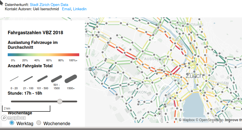
Visualization public transport traffic flow (VBZ), Zurich, Switzerland 1 | © Stadt Zürich Open Data – map data © OpenStreetMap contributors
Mapping
- GIScience Heidelberg and HeiGIT have created a new land use map, initially for all the EU member states, by combining satellite images from Sentinel with OpenStreetMap using machine learning. It is available on OSMlanduse.org. The quality of the new version of OSMlanduse is being validated in an online campaign. You can participate in the Landsense Mapathon. There are different topics, such as nature, urban, agriculture and expert. The validation campaign is supported within the framework of the EU regions week.
- The UK quarterly project for Q4 has been selected as defibrillators.
- Sarah Hoffmann (aka lonvia) informs us, in her blog post, how Nominatim can be used to search for addresses and how Nominatim also now uses the
addr:*tags recorded in OSM to determine addresses precisely. - Diego Cruz proposed the new tag
landuse=dehesato describe a type of man-made land use that has existed for centuries in the Southwestern quarter of the Iberian Peninsula and which is a sparsely-treed forest (Quercus species) in which the ground is cultivated or used as pasture for grazing animals. - Voting started on 12 October on Andrew Harvey’s proposed tag
shelter_type=rock_shelterto mark the difference between the already existingnatural=cave_entranceand a shallow cave-like opening at the base of a bluff or cliff, which may be used to shelter from the weather.
Community
- k_zoar is a Japanese mapper and lets us take part in reviewing his 10 years of contributing to OSM. For years, he was one of only two mappers to publish the Japanese version of weeklyOSM.
- Thomas Skowron has submitted an interim report for his OSMF Microgrants project focused on the OpenStreetMap Calendar, documenting his progress at the halfway mark.
- Richard Fairhurst complained about an undercover change of the Mapbox GL licence.
OpenStreetMap Foundation
- The minutes of the OSMF virtual board meeting on 2 and 3 October have been published. The minutes of the agenda item on a possible move to the European Union, where the OSM database enjoys legal protection, have also been published.
- Ilya Zverev shared
 > his thoughts about recent large-scale payments made by OSMF Board.
 - Simon Poole has left the OMSF’s Licensing Working Group. The team at weeklyOSM would like to thank Simon for his hard work over the years.
 >
> 
Local chapter news
- Minh Nguyen wrote about OpenStreetMap US becoming a local chapter of the OSMF.
Events
- There will be a GIS track at the 18th International Conference on Information Systems for Crisis Response and Management (ISCRAM 2021). You can submit a full paper until 6 December, while short and practitioner papers can be submitted until 31 January 2021.
- The next CH Open Business Lunch will take > place in Basel 26 November, from 11 AM with Stefan Keller and the topic ‘The innovation potential of OpenStreetMap and Wikidata/Wikipedia/Wikimedia Commons’. Language: , Slides: .
- Stefan Keller (Switzerland) reports > that this year’s DINAcon 2020 will take place on Friday 23 October 2020. (This time, as the name suggests, online and not at Well7 in Bern.)
- The keynote speakers for SotM Japan 2020 > , which will be held online on 7 November, have been announced . And registration has also started .
- The programme > for the FOSS4G Japan 2020 Online core day to be held on 8 November has been announced .
- Speakers from HOT, YouthMappers, Facebook, and Microsoft are coming together at the UN World Data Forum on 19 October, 4:00 PM UTC. Find the programme here, and register for your free participation in the online event.
 >
>  .
. >
> Humanitarian OSM
- In collaboration with the Deltares institute and with funding from German International Cooperation Agency, OpenMap Development Tanzania was able to collect accurate and precise river cross-section surveys using an innovative, low-cost technique. This information will help in improving existing flood risk models and prevention.
Maps
- Hartmut Holzgräfe was happy to report that his MapOSMatic instance has rendered 130,000 maps and also announced email conversion and style upgrades.
- Curvature is a programme that analyses the geometry of OSM roads and generates a map of the most twisty roads, colour-coded by how many curves they have.
- Bloomberg described a building resembling Taiwan’s Presidential Office found in the military training base of Zurohe, which is in Inner Mongolia, China. Supaplex writes that you could compare the outline of both buildings on OpenStreetMap.
Open Data
- [1] 15 projects have made it on the DINAcon Awards 2020 shortlist > . Winners in the five categories will be honoured at the Digital Awards Ceremony on 23 October at the online held Conference for Digital Sustainability (DINAcon, register here). Among the finalists are the NeTEx Converter plugin for JOSM, the geo-admin map viewer, and a traffic flow > visualisation from Zurich.
- The Norwegian Mapping Authority ‘Kartverket’ was awarded > ‘National Geospatial Agency of The Year’ by Geospatial Media in the Netherlands. The jury especially noted its international efforts in humanitarian projects, the UN and sea charts. Kartverket has had a significant impact in OSM in Norway due to the large quantity of open data, including high quality orthophotos, which has been most useful, along with import projects related to land cover and road networks.
 >
> Licences
- Nuno Caldeira complained about the incorrect attribution of OpenStreetMap by Mapbox.
Software
- CyclOSM has released its new 0.3.7 version, including many rendering improvements.
- 15 years ago, Immanuel Scholz proudly announced a beta for JOSM, his Java OpenStreetMap Editor. At that time, the software was only capable of reading and saving a local GPX-file, but already had a homepage, wiki and bugtracker!
- A new version of MapComplete has been released by Pietervdvn. This simple editor now has an easy-to-use opening hours selection and a richer selection of background options. In order to celebrate this, an editable map with shops was created through which you can send opening hours directly to OSM. Furthermore, we remind everyone that anyone can easily make their own custom preset (or theme). Yopaseopor figured out how to and has already created ten such themes, which can be found on his wiki.
Did you know …
- … that the website ‘Map of the Week’ recently featured the best map-related manhole covers?
- … the twitch channel of Martijn van Exel as the curious mapper? Martijn is a former member of the OSM US and OSMF Board of Directors and the author of MapRoulette.
OSM in the media
- The Daily Star featured female mappers from YouthMappers Dhaka University Chapter and YouthMappers Regional Ambassador Maliha Mohiuddin to recognise inclusive mapping on the occasion of International Day of the Girl Child.
- The Information reported on an antitrust battle against Google. ‘Credit for that goes to Mapbox’ and further ‘A congressional report on Tuesday, which made antitrust claims against four major tech companies, included a little-noticed allegation that Google Maps abused its market power and harmed its customers’ by not allowing apps using Google’s location data and other providers’ maps or geographical services at the same time.
Other “geo” things
- The European Commission has opened a position for a trainee to explore synergies between INSPIRE and the OpenStreetMap data ecosystems and assess the potential of OSM for the creation and updating of identified high-value datasets.
- The publishers of the decorative atlas Mad Maps have also published a serious game, teaching the basic elements of cartography. You can download it for Windows, Mac and Linux, or play online – but unfortunately it is only available in French.
- Search engine DuckDuckGo now allows route planning in their map service, based on maps from Apple’s Mapkit JS framework. As Golem.de reports > , the location query should be particularly secure because location data is transferred separately from personal information and is deleted after the query.
- dmontagne presented > the results of their effort to georeference and superimpose historical maps on to current ones using the French platform Navigae.
 have also published a serious game, teaching the basic elements of cartography. You can download it for Windows, Mac and Linux, or play
 Upcoming Events
| Where | What | When | Country |
|---|---|---|---|
| Cobb Virtual Academy | OSMUK AGM plus presentations | 2020-10-17 |  |
| Cologne Bonn Airport | 132. Bonner OSM-Stammtisch (Online) | 2020-10-20 |  |
| Lüneburg | Lüneburger Mappertreffen | 2020-10-20 | |
| Berlin | OSM-Verkehrswende #16 (Online) | 2020-10-20 | |
| Nottingham | Nottingham pub meetup | 2020-10-20 | |
| Lyon | Rencontre mensuelle pour tous | 2020-10-20 |  |
| Žilina | Missing Maps Mapathon Žilina #9 (Online) | 2020-10-22 |  |
| Bremen | Bremer Stammtisch | 2020-10-26 | |
| Arlon | Réunion des contributeurs OpenStreetMap | 2020-10-26 |  |
| Salt Lake City / Virtual | OpenStreetMap Utah Map Night | 2020-10-27 |  |
| Düsseldorf | Düsseldorfer OSM-Stammtisch | 2020-10-28 | |
| Salt Lake City / Virtual | OpenStreetMap Utah Map Night | 2020-10-29 | |
| London | Missing Maps London Mapathon | 2020-11-03 | |
| Stuttgart | Stuttgarter Stammtisch (online) | 2020-11-04 | |
| Dresden | Dresdner OSM-Stammtisch | 2020-11-05 | |
| Online | 2020 Pista ng Mapa | 2020-11-13-2020-11-27 |  |
| Online | FOSS4G SotM Oceania 2020 | 2020-11-20 |  |
Note: If you like to see your event here, please put it into the calendar. Only data which is there, will appear in weeklyOSM. Please check your event in our public calendar preview and correct it, where appropriate.
This weeklyOSM was produced by AnisKoutsi, Lejun, MatthiasMatthias, Nordpfeil, NunoMASAzevedo, Polyglot, Rogehm, Guillaume Rischard (Stereo), TheSwavu, YoViajo, alesarrett, derFred, k_zoar, osmapman, richter_fn.