27/06/2024-03/07/2024
SotM France 2024 – Lyon [1] | © OSM-France
Mapping
- Marco Antonio mapped El Cardón National Park in Bolivia using official boundary data from PROMETA, an environmental conservation organization of Tarija, Bolivia.
- Roxystar is currently mapping street lamps in Munich, complete with additional details such as the lamp’s height, to simulate the light coverage by using OSMStreetLight.
- rtnf on Mastodon emphasised the importance of mapping building entrances to help people avoid getting lost, citing personal experience of having to circle a building to find the entrance. znrgl points out in the conversation that it is easy to record entrances with the Every Door at any time while traveling.
- DENelson83 has completed a project to manually map all the forested areas on Vancouver Island from aerial imagery, improving the detail and accuracy of the island’s forested regions on OpenStreetMap.
- Comments were requested on the following:
Mapping campaigns
- The Open Mapping Hub – Asia Pacific from HOT celebrated the winners of the Climate Change Challenge, recognising the efforts to generate valuable data through OpenStreetMap in 14 Asia Pacific countries. Special thanks were given to Open Mapping Gurus from Nigeria, Peru, and Niger, and the winning teams will soon receive their prizes. Countries mapped include Indonesia, India, the Philippines, Nepal, and more.
- Pavy_555 visited JNTU Hyderabad, to promote smart mobile mapping using the Every Door app, emphasising community engagement and the importance of updating OpenStreetMap data with local amenities and micro-mapping efforts.
- IVIDES.org is promoting a campaign
 > for the collaborative mapping of the Brazilian coastal and marine zones. The project uses OpenStreetMap and will be carried out to evaluate aspects related to the sustainability of this strategic region. Registration is open for participation in the pilot mapping and the research coordinator presents the initiative in her diary > .
 >
> 
Community
- The OpenStreetMap community is invited to participate in WikiCon 2024, taking place from 4 to 6 October in Wiesbaden, Germany. Volunteers are needed to staff the OSM booth and promote the project to a wider audience. Travel and accommodation costs can be covered by FOSSGIS e.V. for participants from outside the Wiesbaden or Rhein-Main area. If you are interested, you can note this directly on the wiki page.
Events
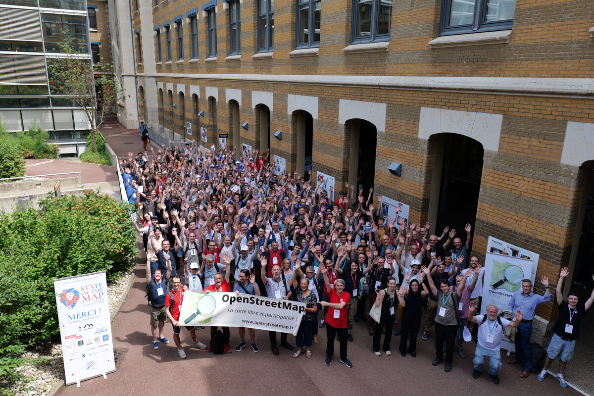
- [1] Bristow presents a photo retrospective of the 10th SotM France conference, held in Lyon from 28 to 30 June 2024. Attendance records were broken, with over 300 people taking part. Recordings of the presentations will soon be available online on PeerTube.
- The deadline for early bird pricing for the 2024 State of the Map from 6 to 8 September has been extended till 31 July.
- The FOSS4G Perth 2024 conference, scheduled for 23 October in conjunction with the ISPRS TC IV Mid-Term Symposium, has opened its Call for Presentations, inviting the open geospatial community to share insights on tools such as QGIS, PostGIS, and OpenStreetMap.
- The State of the Map 2024 programme offers a diverse range of sessions, workshops, and lectures. The event will occur from 6-8 September, in Nairobi, Kenya, covering topics such as sustainable transport, local mapping initiatives, integration into academic curricula, and innovative data collection methods.
 a photo retrospective of the 10th SotM France conference, held in Lyon from 28 to 30 June 2024. Attendance records were broken, with over 300 people taking part. Recordings of the presentations will soon be available online on
 Education
- OpenStreetMap contributor Denis_Helfer is organising an introduction to OSM on the 15 July in Strasbourg, France. This will likely be followed by a series of workshops in autumn.
Maps
- JveuxDuSoleil is a web application that simulates urban shadows to help users find sunny terraces in cities such as Paris, Marseille, and Nantes. Users can zoom in on the map to see where terraces will be sunny at certain times. However, the project faces functionality issues as building models and their shadows are no longer generated due to maintenance issues.
OSM in action
- The ‘Los Pueblos más Bonitos de España’ website offers a guide to the most beautiful villages in Spain, with resources such as an OpenStreetMap-based village map application for geolocalised travel and a guidebook for sale to help organise trips to these charming places.
- The GLOBE programme’s data visualisation tool allows users to explore environmental data collected around the world, filtering by protocol, date range, and geographical location, with options to download and analyse specific datasets for educational and scientific purposes.
- The Toll/ST Ceritapeta tool allows users to visualise and measure driving distances from various toll gates and train station in Jakarta, Indonesia on an OpenStreetMap background. This tool is utilized to aid decision-making when choosing a residential complex in the suburbs of the Jakarta Metropolitan Area, as driving distances to the nearest transportation infrastructures serve as a good indicator of connectivity.
- The Naturkalender ZAMG map allows users to explore various natural observations, such as plant and animal phenology data. It provides detailed visualisations of seasonal changes and species distribution, supporting citizen science, and ecological research.
- The Mosquito Alert map displays real-time reports of mosquito sightings and breeding sites submitted by users on an OSM background, contributing to public health research and control efforts. The interactive map allows users to explore mosquito data geographically, helping to track the spread and presence of different mosquito species.
- Norbert Tretkowski navigated > around Norway using Organic Maps on a Google Pixel 3, detailing the app’s performance and challenges with features such as tunnel navigation, estimated arrival times, and ferry integration.
- velowire.com displays the routes of the most important cycle races on OpenStreetMap maps and offers them for download.
- NNG and Dacia have partnered to offer Dacia drivers OSM based navigation maps, providing a community-driven, frequently updated, and feature-rich map solution to enhance the driving experience.
 a guide to the most beautiful villages in Spain, with resources such as an OpenStreetMap-based village map application for geolocalised travel and a guidebook for sale to help organise trips to these charming places.
 map
map Open Data
- The Heidelberg Institute for Geoinformation Technology (HeiGIT) has made OSM land use data available on HeiData, providing TIFF tiles for EU countries and the UK. This data is derived from Sentinel-2 imagery and OpenStreetMap, which is classified into categories such as agricultural areas and urban regions using a deep learning model. The datasets can be used by urban planners, environmental researchers, and others for various applications.
Software
- Badge(r)s is a location-based GPS game where players collect virtual items, quadrants, and regions, acting as both creators and collectors. Badges, the primary virtual items, appear on the map at specific coordinates or in players’ collections.
- The June 2024 MapLibre newsletter announced two minor releases of MapLibre GL JS, progress on a Vulkan backend for MapLibre Native, and the release of Martin Tile Server v0.14. It welcomed new sponsors and highlights upcoming events including FOSS4G EU and State of the Map Europe.
- Amanda details improvements and ongoing issues with WaterwayMap.org, including a new flow direction grouping feature, bugs in river bifurcation calculations, and gaps caused by geojson-to-vector tile conversion, and invites feedback and discussion from the community.
Programming
- emersonveenstra introduced the ‘Rapid Power User Extension’, a new Chrome/Firefox extension that integrates with OpenStreetMap to redirect edit buttons to Rapid and add Strava heatmap support as overlay imagery. The extension is in early development, and users are encouraged to report issues and suggestions on GitHub.
- Mark Stosberg explored the optimisation of Minneapolis’ low-stress bicycle network connectivity using spatial analysis for generating isochrones to measure bicycle travel distances within the network. He described his process using QGIS, JOSM, and Valhalla to create a customised routing network and generate multiple isochrones. The aim is to prioritise segments for improvement based on their impact on overall connectivity.
- The new osmapiR package is now published at CRAN, the official repository for R packages. After almost one year of development and polishing, the package implements all API calls and includes a complete documentation with examples for all functions. With this publication and existing packages osmdata (implementing overpass calls) and osmextract (work with .pbf files), R is now a first class language to work with OpenStreetMap.
Did you know …
- … the map 1NITE TENT, where private individuals offer overnight accommodation with a tent on their property? This is particularly useful in countries where wild camping is prohibited.
- … about the different tools to convert opening hours into OSM syntax, display them, and fix any errors?
Other “geo” things
- Robin Wilson has created a demo app for searching an aerial image using text queries like “tennis courts” or “swimming pool”. Under the hood, it extracts embedding vectors from the SkyCLIP AI model for small chips of the image and compares them using vector similarity metrics.
- Cameroon and Nigeria have agreed to resolve their long-standing border dispute through joint on-the-ground verification and demarcation, with the aim of completing the process by the end of 2025 without recourse to the courts. The agreement, facilitated by the Cameroon-Nigeria Mixed Commission, focuses on areas such as Rumsiki, Tourou, and Koche, and addresses the challenges posed by Boko Haram terrorism in the region.
- tlohde discussed the concept and application of average colors in digital maps, highlighting how averaging colors can simplify images while maintaining their recognisable features.
- Grant Slater shared that he has updated the ZA-aerial with all the latest 25 cm resolution aerial photos, related to the national coverage of South Africa, provided by the South African National Geo-spatial Information (NGI). The full announcement can be found in the mailing list of the OSGeo Africa.
- The initial release of the Panoramax Android app, announced at the State of the Map France 2024, offers an alpha/beta version available for download as an APK, and will be published on the Play Store and F-Droid. The app allows users to contribute geolocated photos to the Panoramax database, a free alternative to Google Street View for OpenStreetMap.
Upcoming Events
| Where | What | Online | When | Country |
|---|---|---|---|---|
| Tartu linn | FOSS4G Europe 2024 | 2024-06-30 – 2024-07-07 |  | |
| 中正區 | OpenStreetMap x Wikidata Taipei #66 | 2024-07-08 |  | |
| Lyon | Pique-nique OpenStreetMap | 2024-07-09 |  | |
| München | Münchner OSM-Treffen | 2024-07-09 |  | |
| San Jose | South Bay Map Night | ✓ | 2024-07-10 |  |
| Salt Lake City | OSM Utah Monthly Map Night | 2024-07-11 | | |
| Bochum | Bochumer OSM Treffen | 2024-07-10 | | |
| Lorain County | OpenStreetMap Midwest Meetup | ✓ | 2024-07-11 | |
| Amsterdam | Maptime Amsterdam: Summertime Meetup | 2024-07-11 |  | |
| Berlin | DRK Online Road Mapathon | 2024-07-11 | | |
| Wildau | 193. Berlin-Brandenburg OpenStreetMap Stammtisch | 2024-07-11 | | |
| Zürich | 165. OSM-Stammtisch Zürich | 2024-07-11 |  | |
| Portsmouth | Introduction to OpenStreetMap at Port City Makerspace | 2024-07-13 – 2024-07-14 | | |
| København | OSMmapperCPH | 2024-07-14 |  | |
| Strasbourg | découverte d’OpenStreetMap | 2024-07-15 | | |
| Richmond | MapRVA – Bike Lane Surveying & Mapping Meetup | 2024-07-16 | | |
| England | OSM UK Online Chat | 2024-07-15 |  | |
| Missing Maps London: (Online) Mid-Month Mapathon | 2024-07-16 | |||
| Bonn | 177. OSM-Stammtisch Bonn | 2024-07-16 | | |
| Hannover | 2024-07-17 | | ||
| Łódź | State of the Map Europe 2024 | 2024-07-18 – 2024-07-21 |  | |
| Zürich | Missing Maps Zürich Mapathon | 2024-07-18 | | |
| OSMF Engineering Working Group meeting | 2024-07-19 | |||
| Cocody | OSM Africa July Mapathon – Map Ivory Cost | 2024-07-20 |  | |
| Stadtgebiet Bremen | Bremer Mappertreffen | 2024-07-22 | |
Note:
If you like to see your event here, please put it into the OSM calendar. Only data which is there, will appear in weeklyOSM.
This weeklyOSM was produced by Raquel Dezidério Souto, SeverinGeo, Strubbl, barefootstache, derFred, euroPathfinder, mcliquid, muramototomoya, rtnf.
We welcome link suggestions for the next issue via this form and look forward to your contributions.