23/06/2020-29/06/2020
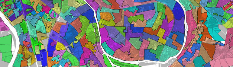
approach for automatic reconstruction of the geometry of polling stations 1 | © Frédéric Rodrigo | map data © OpenStreetMap contributors
About us
- To strengthen our teams, we are urgently looking for volunteer native speakers to help us with proofreading.Okay, I want in. What do I have to do? Just:
- visit https://osmbc.openstreetmap.de/ – then we already have your OSM nickname and an email address for the invitation to our MatterMost instance.
- then please write an email to theweekly[.]osm[at]gmail[.]com, so we know that you want to participate. Then we will send you a link to our internal wiki page where we try to explain how OSMBC works.
Mapping
- Bkil would like your help in improving the definition of a venue mostly serving artisanal desserts made in-house: a cukrászda. He would like some input from mappers in other Central European countries where they also have such amenities. An extensive discussion followed but we would recommend that you don’t read it if you are feeling peckish.
- Joseph Eisenberg asked the tagging list how boundaries of national parks and other protected areas are determined in people’s countries. This was a follow up to Joseph’s question about mapping national forest boundaries on the Talk-us mail list.
- German cities are redrawing road markings to create ‘pop-up’ cycle lanes for the duration of the COVID-19 lockdown, as cyclists demanded more space to physically distance on their commutes to work. Rogehm asked (automatic translation) the German forum for advice on how to map them.
Community
- Rory McCann reported on his OSM activities during the month of May, with much of the work on the OSMF Board of Directors.
- Unfortunately the State of the Map US Planning Committee has had to postpone their November conference. The Committee is currently exploring the possibility of holding a hybrid conference in 2021 with a live track and a virtual track, so that those who cannot attend in person are still able to participate, share their talks, and socialise with those in Tucson. In the meantime they invite you to join one of their many Mappy Hours or find a local event near you.
- Julien Minet writes in his user diary that he, despite having advertised for Mapillary in the past, will no longer contribute to Mapillary, now that it was sold to Facebook. He does not want to support a company earning money from neo-nazis.
- Bryan Housel, who had been working for Mapbox, now works for Kaart, a contractor of Apple and Facebook, on RapiD, a fork of iD which can import features automatically traced from satellite imagery into OSM.
- The Kerala (India) Government has made a documentary on Mapathon Keralam, an initiative to edit OpenStreetMap in the state.
- OSM India volunteer Arun Ganesh has given a demo of Indic map rendering (original tweet).
- User Supaplex030 analysed
 (automatic translation) the parking situation in Berlin’s Hermannstraße using existing OSM data and found interesting insights into the consumption of space by different transport modes.
 (automatic
 Imports
- The Maine Address Import (#492) is finished! Alex Hennings added a Mistakes Were Made section to the import’s wiki page, so others might avoid the same traps. It took nearly a year and he wrote a brief reflection on his experience.
OpenStreetMap Foundation
- FOSSGIS e.V. and FOSSGIS-OSMF-Stammtisch have released a position statement in response to the OpenStreetMap Foundation plans for hiring additional paid staff. The OSMF had explicitly asked for feedback from local chapters. They argue that both the general principles of personnel policy and the concrete creation of new jobs based on a job description should be subject to approval by OSMF members.
- OSMF has a new bank account, as Barclays Bank had terminated the business relationship.
- Joost Schouppe wrote about his life as an OSMF Board member and the reality has far surpassed his expectations. Joost notes that the Board, in his experience, is more productive than previous boards and puts a big part of this down to the new Chair, Allan Mustard.
- Since 1 July the standard style map tiles from OpenStreetMap have been licensed as an ODbL ‘Produced Work’ with no additional terms applied. Simon Poole explains the background and history of this change in the licence in a blog post.
Humanitarian OSM
- SIGenBici has been selected as the #map2020 project of the year. HOT revealed that the project from Medellín, Colombia had been chosen from the 28 groups that participated in #map2020. This project was led by Natalia Arruda and focused on mapping cycling infrastructure within the city. Rebecca Firth and Edoardo Neerhut give more details on the criteria used to select the project of the year and the other seven projects that were finalists.
- Are you a member of a mapping community that is looking for funding to expand your mapping activities? Do you have ideas about how to engage more people and train your community in how to use OpenStreetMap? If so, you can apply for a HOT Community Impact Microgrant.
Maps
- ÖPNVKarte, a map for public transport, will be available as a map layer on openstreetmap.org soon.
switch2OSM
- Proximity_13 reports on reddit that the K9 SAR (rescue dog) teams in the USA are now also using OSM-based maps. He also writes about Map attribution: ‘I was so happy to see that OSM contributors tag’, which should be self-evident, even for ‘big players’. 😉
Open Data
- Since 1 July 2020 the INSPIRE spatial polygon dataset has been available under the Open Government Licence. This dataset maps more than 23 million property title extents across England, Wales and Scotland.
Software
- Sarah Hoffmann announced the release of osm2pgsql version 1.2.2. This is a bugfix release which updates the bundled libosmium only. It fixes an issue where osm2pgsql updates stalled on a large multipolygon relation.
- Release of Nominatim version 3.5.1 has bug fixes for two important issues with osm2pgsql (see osm2pgsql new release above):
- osm2pgsql might get stuck during updates when running with Postgresql 12;
- osm2pgsql might hang when processing extremely complex multipolygons.
- The Heidelberg University’s GIScience Research Group announced that documentation for version 1.0 of the ohsome API has been released.
- The new QGIS 3.14 version adds support for the native loading of vector tiles. Adam Laza’s blog post gives more details.
Programming
- Frédéric Rodrigo wrote (automatic translation) a detailed article on an approach for automatically reconstructing the geometry of polling station catchments. In France electors are required to vote at specific polling stations. If the catchment areas of these polling stations were known, then maps of electoral results could be produced.
- Alex Hennings made a tool to help with bulk tag modifications, expressing them as SQLite queries. Alex created it to help with translation while working on OSM imports and he hopes others find it useful.
Did you know …
- … that RapiD, Facebook’s iD fork to load automatically traced features into OSM, does not offer automatically traced features in Iran and North Korea because they are not allowed to do so under US sanctions?
OSM in the media
- Accenture estimates the value of OSM data at USD 1.67 billion.
Other “geo” things
- Marcel Reinmuth wrote about a method for comparing physical access to healthcare across Sub-Saharan Africa. HeiGIT used hospital locations and the ORS Isochrone service to calculate travel-time distances from hospital locations and the respective reached population per country.
- Steven Feldman reflected on the minor spat that broke out in the Twittersphere between Amber Bosse and Kenneth Field, over Kenneth’s ironic #cartofail decision tree.
- OSGeo:UK ran a one day online FOSS4G event on 17 June 2020. Videos of the presentations are available here.
- Michael Spencer has created a map of the density of public toilets across Scotland. The map is based on public toilet data from OpenStreetMap and the Ordnance Survey’s coastline data.
- Cartography is an extension of political power. China wants to counter the US military aircraft present in the South China Sea and Taiwan Strait, so publicises the tracks of US military aircraft. The SCS Probing Initiative, established by the Peking University Institute of Ocean Research, is monitoring the presence of US military aircraft. They recently showed US military plane activities on a map that complies with Chinese regulations, that is displaying the eleven-dash line, which also includes Taiwan.
- Dustin Carlino released the alpha version of A/B Street, a traffic simulation game built on Seattle OSM data. GeekWire carried a story about Dustin, his game, and what inspired him to build it.
Upcoming Events
| Where | What | When | Country |
|---|---|---|---|
| Taipei | OSM x Wikidata #18 | 2020-07-06 |  |
| London | Missing Maps London | 2020-07-07 |  |
| Lyon | Rencontre mensuelle pour tous | 2020-07-07 |  |
| Berlin | 145. Berlin-Brandenburg Stammtisch (Online) | 2020-07-09 |  |
| San José | South Bay Virtual Hack Night & Map Night | 2020-07-09 |  |
| Munich | Münchner Stammtisch | 2020-07-14 | |
| Nottingham | Nottingham pub meetup | 2020-07-21 | |
| Lüneburg | Lüneburger Mappertreffen | 2020-07-21 | |
| Kandy | 2020 State of the Map Asia | 2020-10-31-2020-11-01 |  |
Note: If you like to see your event here, please put it into the calendar. Only data which is there, will appear in weeklyOSM. Please check your event in our public calendar preview and correct it, where appropriate.
This weeklyOSM was produced by Nakaner, NunoMASAzevedo, PierZen, Polyglot, Rogehm, TheSwavu, derFred, naveenpf.