11/08/2020-17/08/2020
Project of the month 1 | © Projet du Mois | Map data © OpenStreetMap contributors
Mapping
- A green alley proposal from 2013 is revived:
alley=official_green_alley. A green alley is a service alley that residents embellish with vegetation, such as trees, vines and flowers. - Stefan Tauner wonders
 > whether seasonal businesses should be mapped with two nodes. This concerns, for example, bicycle shops that become ski shops, or ice cream shops that are rented out to other businesses in winter.
 - Martin Koppenhoefer has drafted a new wiki page for
tree_lined, a tag for indicating that a feature is tree lined. The tag was discussed > on the German forum. - As part of Ireland’s 2020 Heritage Week, Anne-Karoline Distel created a video showing how to make your own heritage map for historical and heritage societies.
- The proposed tag
leisure=drawing_surfacewould identify walls designated for graffiti. - Woodpeck writes in his blog about why he is now mapping trees in OpenStreetMap and how he is doing that.
 >
> 
Community
- Kwame Odame, a doctoral researcher at the University of Cape Coast, Ghana, shared his experience working as a YouthMappers Regional Ambassador in Ghana. He gave a brief overview of YouthMappers in Ghana and talked about the trips he’s made, giving insights into students’ interaction and the impact he’s made in his role.
- Geoffrey Kateregga wrote in his diary about ‘The State of OpenStreetMap in Africa’, analysing among other things buildings in OSM, buildings per 1000 people, and communication channels.
- The Times of India reports that the OSM Kerala volunteer Manoj Karingamadathil has mapped Kochi Corporation wards at the request of the Ernakulam sub-district collector. News covered by media has raised the need for more open data in India.
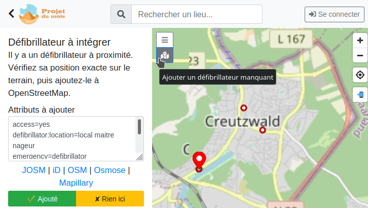
- [1] Adrien Pavie is working with a small team to develop ProjetDuMois > (project of the month) in France, to encourage thematic contributions to OpenStreetMap during a month. The website will offer the community a dashboard with contribution statistics, a web map for efficient mapping, and badges for gamification. Adrien also wrote about his experiences working with full-history OSM files to share his journey with us, hoping to make it easier for others to work with these files.
 >
> Imports
- n76 blogged on the issues he faced while carrying out an import of buildings and addresses in Orange County, California.
OpenStreetMap Foundation
- An OSMF and Cesium joint press release: OpenStreetMap, a map of buildings!
- OSM Buildings.org tweeted that the number of its users confused by ‘Cesium OSM Buildings‘ is rising and complains that the OSMF has not responded to their concerns.
Events
- Mappers and members of emergency organisations > from Switzerland and Austria met online > on 12 August and decided to form a core group > , with its own mailing list, to discuss topics specific to the field of public safety and develop solutions. Existing or implemented solutions include: Defikarte.ch , Notfallkarten , and Feuerwehreinsatzkarten mit OSM .
- The OSM Geography Awareness Week is taking place from 15 to 21 November. A global coalition of partners are hosting mapping events at colleges, community centres and other institutions to map places around the globe. If you are organising an event, or even just thinking about it, get in touch.
Humanitarian OSM
- In recognition of their 10 year anniversary, HOT hosted a webinar on 21 August with members of four OSM communities from around the world to discuss how microgrants have aided their work and growth.
- At the 2020 HOT Voting Members Annual Meeting on Wednesday 12 August, the members confirmed the re-election of Gertrude ‘Trudy’ Hope Namitala, from Zambia, and the election of Felix Delattre, from Germany, as a new Board member. Other candidates in the election were Celina Agaton, Maning Sambale, Matseliso Thobei Letsie, Dale Kunce and Willy Franck Sob. Questions to the candidates and detailed results are presented on the Board Election 2020 wiki page. Matthew Gibb was re-elected as chairperson.With the principle of rotating seat elections, two Board seats were up for election this year, while next year the election will cover the other five Board seats.
- Openstreetmap India has been active in HOTOSM. A small team has formed to create and manage HOTOSM tasks.
- Rebecca Firth, of the Humanitarian OpenStreetMap Team (HOT), gave a TED Talk about how HOT is going to work over the next five years to support the humanitarian mapping community, with the goal of mapping an area home to one billion people.
Education
- The International Journal of Geoinformation (ISPRS), published by MDPI, Switzerland, invites people to submit research papers for an ‘OpenStreetMap as a multi-disciplinary nexus: Perspectives, Practices and Procedures’ issue. The deadline for manuscript submissions is 30 November 2020.
Maps
- Supaplex explained why there is a blank area located south-east of Taiwan’s Taoyuan International Airport on most of the commercial maps available in Taiwan. There is a former military base in this blank area, the former Taoyuan Airbase of ROC Air Force and ROC Navy. The former military airport was once the home base of the Black Cat Squadron, which flew U-2 surveillance planes to investigate nuclear weapon infrastructure and capacity in China, and is mapped in very high detail on OpenStreetMap.
- Mapbox has partnered with Zenrin to provide indoor maps for major metro stations and underground buildings in Japan.
- Visualisations of operational sites and tactical conditions are becoming increasingly important. The fire brigade of Gossau ZH decided > to use OpenStreetMap for the creation of an emergency map. The project started with hydrants, with the intention to able to show the nearest one to firefighters as soon as possible. However, the project was quickly expanded to include additional, mission-relevant data.
- Tatsuo Mitsuchi has created a map in which the colours are painted according to the direction of the road. The distribution of colours seems to reflect > the topography and history of the city. You can try it out on your favourite city on a test server. This system is based on city-roads.
 a map in which the colours are painted according to the direction of the road. The distribution of colours seems to
 switch2OSM
- Microsoft’s new flight simulator uses OpenStreetMap data to procedurally generate cities (we covered earlier). A combination of an ill-conceived university assignment, a bored student, and a typo created a 212 storey house in the outer suburbs of Melbourne, Victoria. The ‘Melbourne Monolisk’ has been attracting attention, including those who have taken the opportunity to land on it before it disappears forever.
Licences
- Nuno Caldeira alerted Mapbox, via Twitter, that their client NOAA is using OSM maps without correct attribution.
Software
- Recently openrouteservice has been updated to version 6.2 by HeiGIT, which has brought some pretty useful features to OSM-based routing. One of the ‘new’ features is the re-introduction of the maximum_speed parameter so users can set the maximum speed their vehicle can travel at.
- Dirk Stöcker announced that the OpenStreetMap Subversion repository is now read-only (we covered earlier). The JOSM and JMapViewer parts have been moved to the JOSM SVN server. For more detail see the source code and developing plugins wiki pages.
Did you know …
- … Anonymaps, the crowdsourced sarcasm on Twitter?
- … the real-time LightningMaps is based on OSM? Also available as App. Lightning is displayed within two seconds!
- … the Android app ‘RADARES of Portugal’ ? It is available for Android devices and provides real-time information on speed radars (fixed or mobile) installed on Portuguese roads. The basemap is OSM.
 ? It is available for Android devices and provides real-time information on speed radars (fixed or mobile) installed on Portuguese roads. The basemap is OSM.
Other “geo” things
- Frederik Ramm asked > on talk-de what the state of the art is for fixed-wing drones and received many hints. [1], [2], [3]
- Manfred Handschuher discussed > the new motorcycle navigation system Garmin Zumo XT.
Upcoming Events
| Where | What | When | Country |
|---|---|---|---|
| Derby | Derby pub meetup | 2020-08-25 |  |
| Düsseldorf | Düsseldorfer OSM-Stammtisch | 2020-08-26 |  |
| London | Missing Maps London Mapathon | 2020-09-01 | |
| Salt Lake City / Virtual | OpenStreetMap Utah Map Night | 2020-09-01 |  |
| Stuttgart | Stuttgarter Stammtisch | 2020-09-02 | |
| Taipei | OSM x Wikidata #20 | 2020-09-07 |  |
| Lyon | Rencontre mensuelle | 2020-09-08 |  |
| Berlin | 147. Berlin-Brandenburg Stammtisch | 2020-09-10 | |
| Munich | Münchner Treffen | 2020-09-10 | |
| Zurich | 121. OSM Meetup Zurich | 2020-09-11 |  |
| Kandy | 2020 State of the Map Asia | 2020-10-31-2020-11-01 |  |
Note: If you like to see your event here, please put it into the calendar. Only data which is there, will appear in weeklyOSM. Please check your event in our public calendar preview and correct it, where appropriate.
This weeklyOSM was produced by MatthiasMatthias, NunoMASAzevedo, PierZen, Polyglot, Rogehm, Sammyhawkrad, Guillaume Rischard (Stereo), Supaplex, TheSwavu, YoViajo, derFred, naveenpf, richter_fn, ᚛ᚏᚒᚐᚔᚏᚔᚋ᚜ 🏳️🌈.