02/14/2017-02/20/2017
Typical errors that can be solved with Jochen Topf’s MapRoulette task 1 | (C) OpenStreetMap Contributors CC-BY-SA 2.0
Mapping
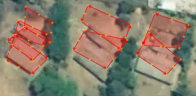
- [1] Jochen Topf has started a Maproulette-Challenge to repair invalid areas in OSM and wrote in his blog about it. Let’s begin with self-overlapping closed ways with tag
building=*. More Challenges - As part of the “fixing broken multipolygons” discussion, Christoph Hormann suggests that removing forest polygons from the old Corine landcover imports might be a better solution than repairing them, because they are very inaccurate.
- CloCkWeRX posts on enhancements proposed to OnOsm.org, some of them have already been accepted, for example, the location helper and internationalization, among others.
- Bryan Housel shows how picnic sites can be mapped easily using the iD editor and multi-selections.
- User Jojo4u proposes a new feature “meadow orchard” (German: “Streuobstwiese”) which is a meadow with scattered fruit trees or fruit trees that are planted in a field. The proposed tagging is possible with combinations of
landuse=meadoworlanduse=orchard. - On talk-fr, Rogelio brings up the matter of toll fee data into OSM. It’s not clear if having this information in OSM is desirable or even feasible but some options are discussed to ease the integration of toll fee prices for OSM-based routing engines.
- Martin Koppenhoefer proposes the documentation of the usage of
amenity=luggage_lockerandamenity=lockertags. This initiates a discussion on the need for two different tags for a seemingly similar utility. - The usage of
amenity=vending_machinetag was discussed at length on the Tagging mailing list including what is within the scope of the term ‘vending’ and what are the alternatives to the amenities tag. - Joost Schouppe writes about evaluating completion of the road map network in Flanders, Belgium. A thorough analysis is made along with many graphs and time-lapse animations.
- User Marczoutendijk wrote an article about the tagging of restaurants and its particularities in OSM. Bon appetit!
- The Mapbox Data Team invites you to map points of interest in San Francisco using JOSM with the Mapillary plugin. A comprehensive guide is provided and the project is open on the Mapbox tasking manager.
Community
- JOSM maintainer Dirk Stöcker is concerned about the increasing gap between the translations. He is told that the launchpad translation platform is the problem.
- Steve Coast showcases his OSM Stats website where the evolution of the various types of ways can be gathered by country. Direct links to: UK and US.
Imports
- Facebook are suggesting that they try again with their “AI-based” road detection. Last time it didn’t work so well. Last time, imports in Egypt and Thailand were reverted because they were “far more wrong than right” (draining ditches being added as “roads”, among other things). Apparently this time they are now working with a larger team of highly-trained mappers and have added steps to the validation process.
- Nick Bolten, of the projects OpenSidewalks and AccessMap, announced a test import of footpaths in Seattle (Washington state). There were already extensive discussions on the mailing lists tagging and Imports.
- Max Bainrot suggests to use the ACTmapi data from Australia for OpenStreetMap. The data is under CC-BY, but there is probably a special permission for OpenStreetMap.
Events
- The submission of talk proposals for the 2017 State of the Map in Aizu-Wakamatsu, Japan is open until April 2nd.
Humanitarian OSM
- Mikel Maron reports that Mapbox has matched a US$ 10,000 grant to the HOT Microgrants Program (which we reported earlier).
- User MangleBlanco writes about impressive geological history of the Southernmost tip of the Caribbean Sea and why open source data might be key to sustainable development in the region. He also pledges to provide high resolution data for mapping efforts and humanitarian projects in the area.
- It seems that Fred Moine is not quite convinced by the quality of the mapping in Haiti by HOT volunteers.
Maps
- The OSM website now has a new right-click context menu which was programmed by user mcld. You can now set directions to and from points, centre the map, add notes, etc. The item “show tile image”, which was available in the previous browser-default image context menu, is missing. Ilya Zverev proposed to add it, but his pull request was denied – a long list of comments criticizing Tom followed.
- Mapzen added a new feature to the Who’s On First Spelunker: the Bundler. Now, after you selected a place, downloading a GeoJSON blob containing all its descendants with selectable categories is a few clicks away!
Open Data
- Do you already know the Open Digital Elevation Model – “The Portal for sharing the 3rd dimension”? At the beginning of the year, North Rhine-Westphalia (DE), Belgium, New Zealand and Switzerland joined.
- Open data under Trump probably doesn’t exist any more. The White House’s Open Data Portal has been emptied, user @denormalize reported on Twitter.
Licences
- KSJ2 data in Japan must not be imported any more because the terms of use have been changed (source).
Software
- An introduction tutorial for QGIS Atlas, a QGIS feature (formerly a plug-in) that allows you to create map snippets around a collection of features (eg a POI shape file).
- Ilya Zverev announced a new import tool. The OSM Conflator checks for matching objects in the OSM data. It adds tags to existing objects or creates new nodes for unmatched points.
- Martin Ždila announced his Toposcope Maker. Toposcopes can be found on top of hills or high places which indicates the direction to notable landscape features or cities.
Programming
- Frederik Ramm (woodpeck) submitted a pull request which would allow the geometry of deleted OSM objects to be displayed on “browse” pages. It was rejected for various technical reasons – see this comment by Matt and the comments above for a summary.
- Geofabrik announces that the download server now has full history files for all regions served. These files (called “.osh.pbf”) can be used to run analyses, and one can use Osmium to convert them to a text-based format (“OPL”) that is then accessible for grep et al.
Releases
| Software | Version | Release date | Comment |
|---|---|---|---|
| SQLite | 3.17.0 | 2017-02-13 | 15 enhancements and three bugfixes. |
| MapContrib | 1.4 | 2017-02-14 | Update the changeset comment, MapContrib is not a prototype anymore. |
| Mapillary iOS * | 4.6.6 | 2017-02-14 | Fixed photo meta data to be compatible with server. |
| OpenLayers | 4.0.1 | 2017-02-14 | Bugfix release. |
| OpenStreetCam | 2.0.0.2 | 2017-02-16 | Reward system with top list. |
| Overpass-Turbo | 2017-02-18 | 2017-02-18 | Switched to OSMNames geocoder for map location search, improvements to mapcss, updated translations |
Provided by the OSM Software Watchlist.
(*) unfree software. See: freesoftware.
Did you know …
- …the historic maps of Berlin? Here you can see them as an adjustable transparent layer on top of OSM.
OSM in the media
- An article (automatic translation) in Swiss media talks about three map services to navigate in Switzerland, which offer more accuracy than Google Maps. Guess what? OpenStreetMap is one of them.
Other “geo” things
- A podcast from BBC Radio 3 in the UK, is available worldwide, handling contents about the UK and Germany. The podcast has no OSM content, but it discusses in general and particular what borders mean to people.
- An article
 discusses the App “Metro” which provides routing through the public transportations network in Havana, Cuba.
 - A single Indian rocket launched 104 satellites into space, including 88 micro satellites for Earth observation of the US start-up Planet.
- Ever wondered how each of the US states would compare to an European area with similar population? Wonder no more!. And how about European countries over the American continent? Speech500 has you covered too.
- The xkcd webcomic strip shows us how the world would look like if we were to correct every country’s layout by their timezones.
 discusses the App “Metro” which provides routing through the public transportations network in Havana, Cuba.
Upcoming Events


Note: If you like to see your event here, please put it into the calendar. Only data which is there, will appear in weeklyOSM. Please check your event in our public calendar preview and correct it, where appropriate.
This weeklyOSM was produced by Nakaner, Peda, Polyglot, Rogehm, Sadless74, SomeoneElse, Spec80, SrrReal, YoViajo, derFred, jinalfoflia, keithonearth, kreuzschnabel, vsandre, widedangel.