26/09/2017-02/10/2017
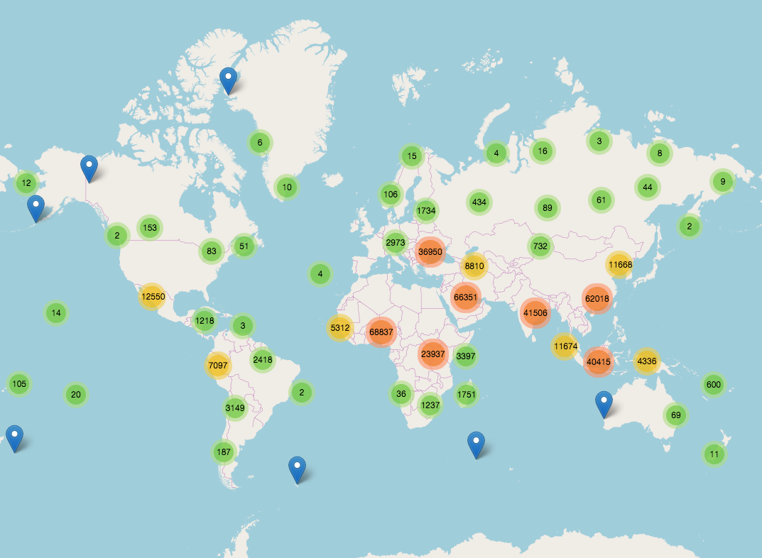
A map of unmapped places around the world 1 | Copyright © Pascal Neis (neis-one.org) – Map data © OpenStreetMap contributors
Mapping
- A new task on MapRoulette. Help clean up non-existing schools from the GNIS US 2009 import.
- Florian Lainez announced proudly on the French mailing list, that in Accra, the main city of Ghana 320 minibus lines with stops are now available in OSM thanks to Jungle Bus. A week after he asked for help with rendering on a website, the rendering of Mapanica was adapted and now you can see all the lines here.
- The discussions about large-scale modifications of the
wikidata=*tag started by Yuri Astrakhan (we reported in our last issue) are still going on and have been amended by further discussion topics and threads:- mechanical edit on
brand:wikidata=* - Yuri would like to write a programme which semi-automatically fixes
wikipedia=*and/orwikidata=*tags on objects whosewikipedia=*does not match theirwikidata=*tag but other mappers suggest him to do this completely manually. - addition of
wikidata=*to all objects which only have awikipedia=*tag - iD-Bugtracker: Display Wikidata label in Wikipedia field
- mechanical edit on
- We reported in September Statistics Canada workshop in Ottawa to present a pilot project with the local OSM community to map all buildings in Ottawa. This time on Talk-ca StatCan, propose a goal for the OSM community to add all buildings in Canada by the year 2020. Some contributors on the talk-ca list expressed the opinion that this goal is not realistic with the difficulty to negotiate licenses with municipalities and without a clear engagement from StatCan.
- Martijn van Exel from Telenav asks on Talk-ca mailing list how to tag bilingual destination signs (e.g. “Rue Regent St”).with key
destination:street - User Gorm presents a new JOSM plugin: Roundabout Expander, to help mapping these features from a single node.
- Mateusz Konieczny proposes to generate lists of objects that need our attention, like statues referring directly to a person instead of using subject:wikipedia/subject:wikidata tags or OSM objects for which Wikidata has a web url, that can be added to OSM as website tag.
- Voting is open on the Fire Hydrant Extension wiki page proposal until October 15th. It adds new tags but also replaces existing ones.
Community
- Matthew Darwin proposes to the folks on Talk-ca mailing list to meet at State of the Map US (20th–22nd October) and discuss about founding a local chapter of OSMF.
Imports
- Enock Seth Nyamador wants to import 216 District Borders into OSM and asks for advice.
- The buildings import for Denver Metropolitan area is ready. Russell Deffner wrote an update at the import mailing list. At the wiki, you can read about the import in detail.
OpenStreetMap Foundation
- Tom Hughes confirms on OSM-dev that the OSRM routing service is not available anymore. The demo server on osm.org was provided by Mapbox and has been put down without any prior notice. There is an ongoing discussion in this pull request about commercial services and various possibilities around using them.
- Joost Schouppe started on osmf-talk the discussion about sponsored OSM Foundation memberships with the expressed objective to help increase diversity among members.
- Already participated in the survey of the DWG? (we reported last week).
Events
- Rob Nickerson one of the organisers of the State of Map shared a budget for a generic large State of the Map events, this will be a useful reference for organising similar events in the future.
Humanitarian OSM
- The DailyMail reports how the Nigerian youth “armed with smartphones and boots” mapped flooded areas in Niamey.
- The developers of Ushahidi, a tech platform for social activism, attended the HOT summit 2017 and share their experience in a blog post.
Maps
- [1] Pascal Neis updated his map of unmapped places around the world.
- Ilya Zverev wrote a script to inventorying
railway=subwaystations in major cities around the world for use in MAPS.ME. which means it will be the first app that uses solely OSM data for routing passengers. Michael Reichert informs that Geofabrik also develops a Public Transport version 2 validator. - There was an issue raised in help.openstreetmap.org about a delay in updates between OpenStreetMap and Strava maps which uses Mapbox. Mapbox states that they can’t guarantee a timeframe for the edits to appear but they appreciate everyone’s contributions and are continuing to work hard to make sure their maps are up-to-date.
- The University of Heidelberg has produced a map “osmlanduse.org” that analyses OSM landuse in an area (and also uses some remote sensing data). An introduction is here and the map is here.
Open Data
- Heise writes (automatic translation) about a proposed EU directive compelling open source platforms to monitor their data for copyright infringements at high expenses.
Software
- Kort Game, an app for Android and iOS to add missing information to existing objects in OpenStreetMap got published. The app follows a gamification approach that pays out so called Koins for each question answered, and only when a response has been verified by another user, and then is it added to the OSM database. The question remains how such a verification will allow to get edits in rural areas added to OpenStreetMap. The development of Kort happens on GitHub. The translation on Transifex. The Kort Game App is available for Android and iOS. It is already being used – and discussed.
Programming
- In OSM help forum, karussell, account of the developers of Graphopper routing engine, seeks an answer for the default access values that should be assumed for a ferry, a ford and a barrier when it comes to a routing engine.
- Chris Whong has written an express.js server that allows to quickly load Mapbox GL styles from any project into the Maputnik Style Editor.
Releases
- Mapbox Navigation SDK for Android v0.6.0 adds a prebuilt user interface similar to the one in the iOS version
Did you know …
- … Achituv Cohen’s thesis (PDF) on “Building a Weighted Graph based on OpenStreetMap Data for Routing Algorithms for Blind Pedestrians”?
- … Marble, the online globe for Linux, Mac, Windows and Android with OSM maps?
- update: …WHODIDIT to analyze OpenStreetMap changesets? Ilya recommends a faster fork. 😉
OSM in the media
- The New York Times reports on “A Mapathon to Pinpoint Areas Hardest Hit in Puerto Rico”.
- A reddit user shares an animated GIF that shows hurricane Jose predicted path.
- TV network WCPO reports about a mapping event at Miami university helping to face the hurricane damage in Puerto Rico. OSM is only mentioned in one brief direct quote, though.
Other “geo” things
- An article in The Guardian reports on the wheelchair accessibility issues of metro networks around the world. The results are discouraging.
- HOT is searching for a Director of Finance & Administration (Part-Time) to join their senior management team.
- According to The Guardian, “Google Maps must improve if it wants cyclists to use it”. However, commenting users (apart from some militant pro- and anti-cycling trolls) seem to be managing just fine without it. Cited competitors such as CycleStreets, Map.Me are not clearly identified as being part of the OSM Ecosystem.
- NASA has released a tool that makes it easy to discover satellite images of recent natural phenomena such as hurricanes, forest fires, icebergs, algae blooms, volcanoes and more. Additional information was shared by a developer on Reddit.
Upcoming Events
| Where | What | When | Country |
|---|---|---|---|
| Morbihan | Opération Libre du Pays de Redon, Peillac et Les Fougerêts | 2017-10-07-2017-10-08 |  |
| Dortmund | Mappertreffen Dortmund | 2017-10-08 |  |
| Fukuchi Machi | 福智町の歴史・文化まち歩きプロジェクト~自分のチカラで世界中にタカラ発信!~ | 2017-10-08 |  |
| Rennes | Réunion mensuelle | 2017-10-09 | |
| Lyon | Rencontre mensuelle ouverte | 2017-10-10 | |
| Munich | Stammtisch | 2017-10-10 | |
| Rostock | Rostocker Treffen | 2017-10-10 | |
| Viersen | OSM Stammtisch Viersen | 2017-10-10 | |
| Berlin | 112. Berlin-Brandenburg Stammtisch | 2017-10-13 | |
| Hérault | Opération libre à Jacou, Jacou | 2017-10-13-2017-10-15 | |
| Tokyo | 東京!街歩き!マッピングパーティ:第12回 旧古河庭園 | 2017-10-14 | |
| Turin | Muoversi a Torinoː Torino mapping party | 2017-10-14 |  |
| Caen | Carto-Party : Environment et Arbres | 2017-10-14 | |
| Bonn | Bonner Stammtisch | 2017-10-17 | |
| Lüneburg | Mappertreffen Lüneburg | 2017-10-17 | |
| Scotland | Pub meeting, Edinburgh | 2017-10-17 |  |
| Karlsruhe | Stammtisch | 2017-10-18 | |
| Leoben | Stammtisch Obersteiermark | 2017-10-19 |  |
| Colorado | Boulder]] | State of the Map U.S. 2017, [[Boulder | 2017-10-19-2017-10-22 |
| Karlsruhe | Hack Weekend October 2017 | 2017-10-21-2017-10-22 | |
| Buenos Aires | FOSS4G+State of the Map Argentina 2017 | 2017-10-23-2017-10-28 |  |
| Brussels | FOSS4G Belgium 2017 | 2017-10-26 |  |
| Lima | State of the Map LatAm 2017 | 2017-11-29-2017-12-02 |  |
| Yaoundé | State of the Map Cameroun 2017, lors des premières Journées nationales de la Géomatique | 2017-12-01-2017-12-03 |  |
| Bonn | FOSSGIS 2018 | 2018-03-21-2018-03-24 | |
| Milan | State of the Map 2018, (international conference) | 2018-07-28-2018-07-30 | |
Note: If you like to see your event here, please put it into the calendar. Only data which is there, will appear in weeklyOSM. Please check your event in our public calendar preview and correct it, where appropriate.
This weeklyOSM was produced by Laura Barroso, Nakaner, PierZen, Polyglot, SeleneYang, SomeoneElse, Spanholz, Spec80, YoViajo, derFred, jinalfoflia, k_zoar, kreuzschnabel.
Hi, the link to my script (for railway=subway) is broken. Also, wrt WHODIDIT, you should mention a faster fork: http://simon04.dev.openstreetmap.org/whodidit/
Hi Ilya, thanks for the hints. Updated! – Sorry for any inconvenience.