2021.11.30.-2021.12.06.
IIEP UNESCO와 마다가스카르 교육부에서 공동으로 주최한 지도 제작 캠페인 [1] | © IIEP UNESCO & Madagascar Ministry of Education | map data © OpenStreetMap contributors
속보
- 12월 12일에 개최된 오픈스트리트맵 재단 연례 이사회의에서 이사장 Allan Mustard가 투표 결과를 발표했습니다. Guillaume Rischard, Amanda McCann, Mikel Maron이 재선에 성공했으며, Roland Olbricht가 새로운 이사가 되었습니다. 총 742명이 투표에 참여했습니다. 상세한 정보는 여기를 참고하세요.
지도 제작 캠페인
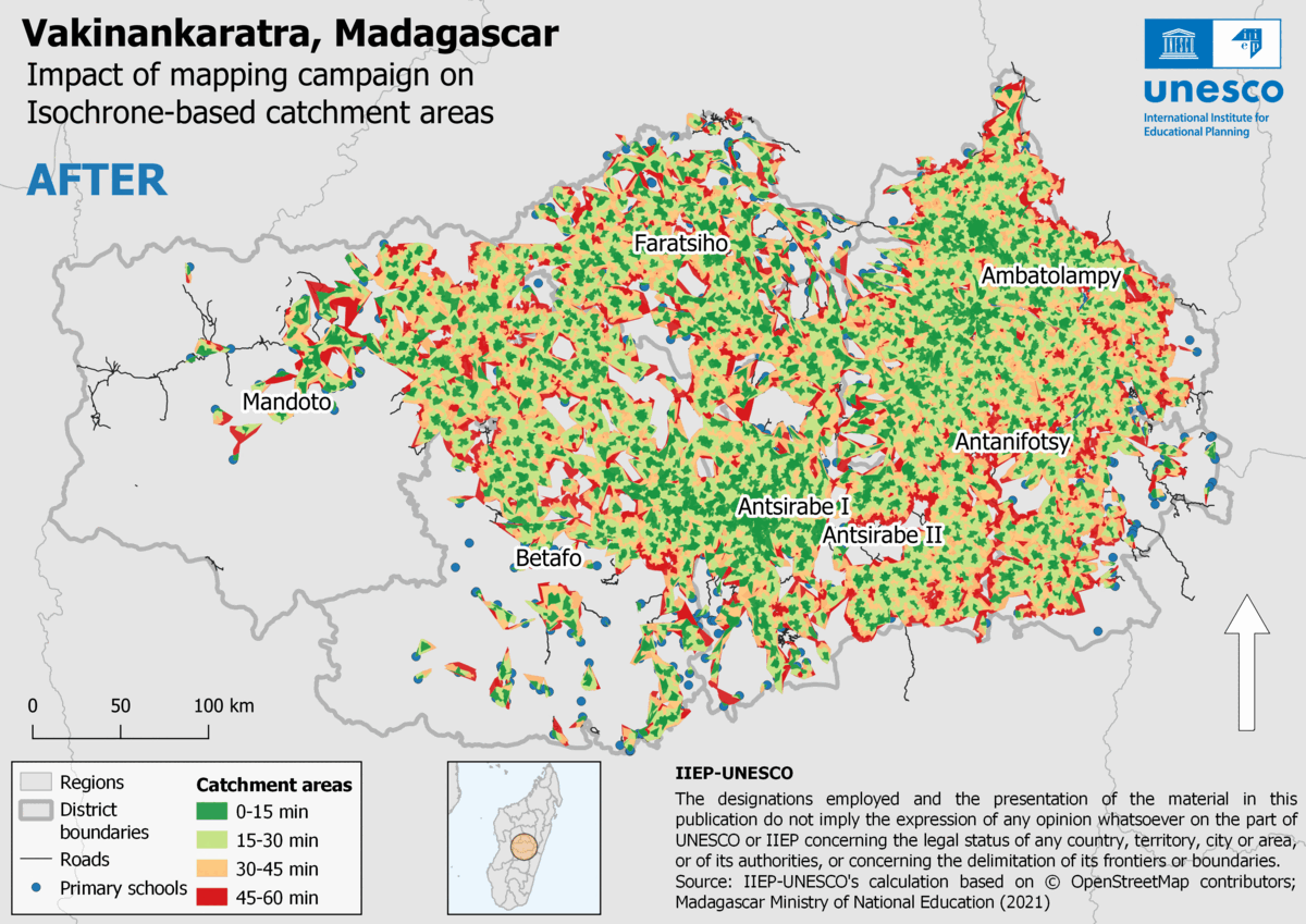
- [1] 마다가스카르 교육부와 UN Mappers에서 공동으로 IIEP UNESCO 지도 제작 캠페인을 진행한 결과, 900명에 육박하는 자원봉사자들이 고급 교육을 받고 바키낭카라트라지역 도로를 9,845 km 매핑했습니다. 이제 전체 학교의 97%가 도로망에 연결되어 있습니다. 프로젝트 시작 전에는 겨우 절반만 도로망에 연결되어 있었다는 것을 고려하면 매우 큰 발전입니다. 매핑된 도로망은 IIIEP-UNESCO 학교 수용 인원 플러그인으로 학생들이 등하교하는 데 걸리는 시간을 계산하는 데 활용되었습니다.
지도 제작
- darkonus가 애플 실리콘 AP가 탑재된 맥에 JOSM을 설치하는 방법을 소개했습니다.
- Forteller가 자전거로 현지 조사를 하는 방법을 소개했습니다. Forteller는 이 방법으로 노르웨이 오슬로의 공원을 100개 이상 오픈스트리트맵에 추가했으며, 한 번도 가보지 않은 곳을 이번 기회에 가 보면서 경험을 쌓을 수 있었습니다.
- 피드백을 받고 있는 제안들은 다음과 같습니다.
amenity=library_dropoff: 도서관 책을 반납하는 무인함을 나타내는 태그.ele=*태그에 미터 값뿐만 아니라 피트나 인치 값도 넣을 수 있게 하자는 제안.
커뮤니티
- 칠레 발디비아 도심부의 나무를 오픈스트리트맵에 매핑하는 작업을 진행하고 있는 OpenMapChile이 지금까지 15,062개의 나무를 추가했다고 발표했습니다.
- OpenStreetMap Belgium에서 12월 이 달의 매퍼로 러시아에 거주하는 d1sr4n을 선정했습니다.
- 호주 빅토리아주에 거주하는 초보 오픈스트리트맵 기여자 TechnicallyNotDeaf가 지난 한 주 동안 배운 것들을 정리했습니다.
- pedr0faria가 제2회 UN 지도 마라톤에서 우승했습니다. UN 지도 마라톤(UN Map Marathon)은 UN Mappers에서 오픈스트리트맵 기여를 장려하기 위해 개최하는 대회로, 오픈스트리트맵에 의존하는 각종 UN 프로젝트의 성과를 올리는 것을 목표로 합니다.
오픈스트리트맵 재단
- 가입 작업반의 Michael Spreng이 선거 기간 동안 매우 많은 메시지를 받았다면서, 이제 talk-osmf 메일링 리스트에 올릴 수 있는 메시지의 수를 개인별로 하루에 한 개로 제한한다고 발표했습니다.
오픈스트리트맵 연구
- 한 과학 기사에서 온라인/오프라인 지도 제작을 고찰했습니다.
 > 해당 기사에는 오픈스트리트맵이 여타 지도와 달리 사람의 존재를 강화한다는 내용이 언급되어 있습니다.
 >
> 
지도
- Yves가 OpenSnowMap 홈페이지를 모바일에서도 손쉽게 이용할 수 있도록 업데이트했습니다. 당분간은 기존 스타일의 홈페이지도 이용할 수 있으며, 만약 원하신다면 메뉴에서 ‘LEGACY OPENSNOWMAP.ORG’를 클릭하시면 됩니다.
열린 데이터
- Michael Cieslik이 오픈스트리트맵 데이터를 LOD2 스타일로 3D 렌더링한 건물의 높이와 기존에 공개된 고도 데이터를 결합하는 방법을 보여주었습니다. Michael은 트위터에서도 오픈스트리트맵 데이터의 불완전성과 이를 해결할 잠재적인 수단을 언급했습니다.
소프트웨어
- 소프트웨어 주권에 관해 토론하는 스레드에서 Roland Olbricht가 Overpass API는 버스 지수(팀 프로젝트에서 몇 명이 빠져야 프로젝트가 와해되는지를 나타내는 수. 버스 지수가 낮다는 것은 한두 명에게 큰 역할을 몰아 주고 있다는 의미이다. – 역주)가 낮다고 지적했습니다. mmd는 단순히 프로젝트를 포크하는 것만으로는 버스 지수를 높일 수 없으며, 단순히 개발자의 수가 많은 것보다는 쏟아지는 질문에 인내심을 갖고 답변해 주는 유지보수자의 존재 등이 버스 지수에 더 큰 영향을 미친다고 말했습니다. >
- OSM 환영 도구 개발팀에서 국가 추가 요청을 받고 있습니다. 자세한 방법은 위키 문서를 참고하세요. 오픈스트리트맵에 입문한 지 얼마 되지 않은 사람이라면 OSM 환영 도구에 피드백을 남겨 주세요.
- Robhubi가 GIP의 데이터를 오픈스트리트맵과 비교하는 방법을 설명했습니다 > GIP(Graph Integration Platform, 그래프 통합 플랫폼)은 오스트리아의 교통 노선 정보를 수집하고 공유하는 온라인 체계입니다.
- 러시아의 페이스북이라 불리는 ex-MailRu Group을 운영하는 VK에서 Overpass Turbo를 자체적으로 운영하기 시작했습니다. 사용 방법은 여기에서 볼 수 있습니다.
 >
> 기타 ‘지리’ 관련 소식
- Anonymaps에서 아무런 보상 없이 이용자들에게 지도를 그리게 한다고 말했습니다.
- 구글 지도에서 ‘구원의 대성당‘이 ‘넌센스의 대성당’으로 바뀐 것에 대해 루마니아 정교회가 구글을 고발한 소송에서 루마니아 부쿠레슈티 법원이 정교회의 손을 들어 주었습니다.
- 하이델베르크 대학교 지리정보학과에서 시간제 연구 조수를 구하고 있습니다. 하이델베르크 대학교 지리과학 연구에서는 최근 공간 정보 과학과 기계 학습(여기서는 딥러닝)을 결합해 고해상도 CO2 배출원 지도를 구축하는 GeCO 프로젝트를 진행 중입니다.
- 구글 멕시코에서 전체 상업의 절반을 차지하는 노점을 지도에 추가하는 협업 지도 제작 프로젝트를 제안했습니다. 노점은 지도에 표시되지 않기 때문에, 구글 멕시코에서는 프리랜스 데이터 분석가가 제작한 커스텀 지도에 주목했습니다.
다가오는 행사
| 장소 | 명칭 | Online | 일시 | 국가 |
|---|---|---|---|---|
| 建设街道 | 长株潭区域作业绘图后续修正 | 2021-12-10 – 2021-12-15 |  | |
| Grenoble | OSM Grenoble Atelier OpenStreetMap | 2021-12-13 |  | |
| 臺北市 | OSM x Wikidata Taipei #35 | 2021-12-13 |  | |
| OSMF Engineering Working Group meeting | 2021-12-13 | |||
| Toronto OpenStreetMap Enthusiasts Meeting | 2021-12-14 | |||
| Washington | MappingDC Mappy Hour | 2021-12-15 |  | |
| 20095 | Hamburger Mappertreffen | 2021-12-14 |  | |
| Derby | East Midlands OSM Pub Meet-up : Derby | 2021-12-14 |  | |
| Reunión mensual de la comunidad española | 2021-12-14 | |||
| Decatur County | OSM US Mappy Hour | 2021-12-16 | | |
| 京都市 | 幕末京都オープンデータソン#15:岩倉具視と岩倉村 | 2021-12-18 |  | |
| Lyon | Rencontre mensuelle Lyon | 2021-12-21 | | |
| Bonn | 146. Treffen des OSM-Stammtisches Bonn | 2021-12-21 | | |
| Lüneburg | Lüneburger Mappertreffen (online) | 2021-12-21 | | |
| 京都市 | 京都!街歩き!マッピングパーティ:第28回 智積院 | 2021-12-25 | | |
| Bremen | Bremer Mappertreffen (Online) | ✓ | 2021-12-27 | |
| Düsseldorf | Düsseldorfer OSM-Treffen (online) | 2021-12-29 | |
참고: 행사를 여기에 추가하고 싶다면, 캘린더에 행사 일정을 작성해 주세요. 캘린더에 있는 데이터만 주간OSM에 나타납니다. 캘린더 미리보기에서 행사를 확인하고, 만약 행사 정보가 틀렸다면 적절하게 수정해 주세요.
이 주간OSM은 다음 사람들이 제작했습니다. LuxuryCoop, TheSwavu, derFred.