22/05/2018-28/05/2018
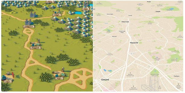
Baran Kahyaoglu demonstrated the Mapbox Unity SDK with a Civilization game style real world map 1 | © Baran Kahyaoglu
About us
- Changes to the GDPR – Due to the changed legal situation, we have changed our data protection declaration (privacy policy).Important for those who receive our blog by email:
If would like us to keep sending you the weeklyOSM newsletter, you don’t need to do anything. By taking no action, you implicitly authorize us to keep sending you the newsletter.
If you no longer wish to receive weeklyOSM in your mailbox, please send us an email with the note „remove” and your email address will be removed from our mailing list immediately.
Mapping
- Gaurav Thapa from OSM Nepal asks on the talk list about mapping more metadata for schools. The answers examine the new metadata (students’ and teacher’s statistics especially) but suggest to store them elsewhere, for example Wikidata, that has specific support for such historical statistics.
- Mateusz Konieczny opened the discussion to revise the good practice of „Don’t map temporary events and features”. The issue edges on the frequency of occurrence (weekly, monthly, yearly…).
- Polyglot proposes
role=reverseto indicate on a bus route that the vehicle needs to reverse out, in order to exit narrow dead end streets. It is not expected that this role will see much use, as this is extremely uncommon along the public transport routes, but the role would elegantly describe what is going on. - After some discussion on the tagging mailing list, it became clear that the English term „roundtrip” has a different meaning to one that many people had expected it to have. The English word „round trip” resembles „rondreis/rondgang” (tour) in Dutch or „rundfahrt” (guided tour, race stage) in German. It seems the contributors to the discussion can agree on a new tag
circular_route=yesfor routes that return where they started (or very close to it) and maybeclosed_loop=yes/nofor QA purposes when all the ways in a route relation form a closed loop. - SunCobalt questions and analyses the increasing Data Working Group user blocks. He seems concerned that there may be too many such blocks, but it could be just as well that growth in user numbers also brings along more users with undesirable behaviour.
Community
- CityLab reported on a mapathon aimed at public transportation by University of Maryland students.
- Baran Kahyaoglu demonstrated the Mapbox Unity SDK with a Civilization game style real world map. Watch it on Youtube or read some comments on Reddit.
- Alban Vivert, OSM France community member and CartONG NGO volunteer, started his cycling Andean cartographic itinerary at the beginning of May. Follow his South American adventure
 with an interactive map of the project, GPS traces (with elevation profile), and contributions to Mapillary.
 - Tyrallová and Harald Schernthanner presented a practical introduction to OpenStreetMap in a science day. The participants learned how to record geodata on their smart-phones and PCs and then prepare and upload it to OSM. In addition to this 'hands-on tutorial’, it was demonstrated that the data can be used, for example, for pedestrian navigation. The slide deck is available.
- Nicolas Chavent publishes a Twitter moment that shares pictures from the two weeks of organizational-governance-tech workshop related to OSM and free Geomatics in Lomé (Togo) targeted to OSM community trainers from Benin, Burkina Faso, Ivory Coast, Mali, Niger and Togo with the support of the International Organization of Francophonie (OIF).
- Rene78 recounted a choice encounter in Myanmar while travelling a path he arm-chair mapped in preparation for his travels.

 with an interactive map of the project, GPS traces (with elevation profile), and contributions to Mapillary.
 a practical introduction to OpenStreetMap in a science day. The participants learned how to record geodata on their smart-phones and PCs and then prepare and upload it to OSM. In addition to this 'hands-on tutorial’, it was demonstrated that the data can be used, for example, for pedestrian navigation. The
 OpenStreetMap Foundation
- The minutes of the IRC meeting of the OSMF Data Working Group on May 10th have been published.
Humanitarian OSM
- Faults in the reservoir of Hidroituango could precipitate a flood in the Lower Cauca, Colombia affecting 12 municipalities. OSMColombia’s project 108 endeavours to map the affected area and help emergency agencies measure the possible damage. Please help if you can.
Programming
- daniel-j-h from Mapbox writes about implementing reasonable alternative routes in the Open Source Routing Machine’s Multi-Level Dijkstra mode.
- Rafael Troilo from HeiGIT gives a short overview of the access layers of the OSM History Analytics platform
ohsomewith the new OSM History Database OSHDB. - hesidoryn reported his progress in implementing the OpenStreetMap API using Go language from Google Summer of Code 2018.
Releases
- Gisgraphy 5.0 is available. It allows forward and reverse geocoding, auto-completion, interpolation, location bias, find nearby, street search for vehicle tracking. All is open source and can be run offline (local installation), though some hosted services are also proposed. Some importers are using a consolidated database from open datasets (OpenStreetMap, OpenAddresses, GeoNames, and QuattroShapes); to prepare the next version, David Masclet asks for people that have already worked with Tiger data to help to code its importer.
OSM in the media
- The Economist writes about the OSM volunteers coordinated by OSM-DRC that map the North of the Democratic Republic of Congo to support humanitarian organizations in the field that fight the progression of the Ebola outbreak.
- CBC-Toronto published a podcast (and transcript) about the coordinated efforts of DRC government, World Health Organization (WHO), United Nations, Doctors Without Borders and OSM volunteer mappers to provide a more reliable map of the Democratic Republic of Congo, currently affected by an Ebola outbreak.
Other “geo” things
- Brian Tomaszewski presents his experience in the Zaatari refugee camp in Jordan, empowering displaced people by teaching mapping and GIS skills.
- An article in Pacific Standard magazine states „Inaccurate beliefs about climate change and flood risk could crash housing prices in the next 20 years, according to new research by American economists.”
- Sasha Trubetskoy created an accurate transit-style map of the ancient Roman roads of Italy, based on the rich historical record on the topic.
Upcoming Events
| Where | What | When | Country |
|---|---|---|---|
| Montreal | Les Mercredis cartographie | 2018-06-06 |  |
| Praha – Brno – Ostrava | Kvartální pivo | 2018-06-06 |  |
| Stuttgart | Stuttgarter Stammtisch | 2018-06-06 |  |
| Moscow | Schemotechnika 16 | 2018-06-06 |  |
| Bochum | Mappertreffen | 2018-06-07 | |
| Potsdam | 120. Brandenburg-Berlin Stammtisch | 2018-06-08 | |
| Tokyo | 東京!街歩き!マッピングパーティ:第20回 江戸開城の地 芝 | 2018-06-09 |  |
| Rennes | Cartographie des bâtiments en 3D | 2018-06-10 |  |
| Rennes | Réunion mensuelle | 2018-06-11 | |
| Lyon | Rencontre mensuelle pour tous | 2018-06-12 | |
| Nantes | Réunion mensuelle | 2018-06-12 | |
| Munich | Münchner Stammtisch | 2018-06-14 | |
| Lüneburg | Lüneburger Mappertreffen | 2018-06-19 | |
| Cologne Bonn Airport | Bonner Stammtisch | 2018-06-19 | |
| Sheffield | Pub Meetup | 2018-06-19 |  |
| Viersen | OSM Stammtisch Viersen | 2018-06-19 | |
| Karlsruhe | Stammtisch | 2018-06-20 | |
| Leoben | Stammtisch Obersteiermark | 2018-06-21 |  |
| Essen | Mappertreffen | 2018-06-22 | |
| Kyoto | 幕末京都マッピングパーティ#05:会津藩と京都守護職 | 2018-06-23 | |
| Essen | 4. OSM-Sommercamp und 10. FOSSGIS-Hackingevent im Linuxhotel | 2018-06-22-2018-06-24 | |
| Rome | Incontro mensile | 2018-06-25 |  |
| Bremen | Bremer Mappertreffen | 2018-06-25 | |
| Milan | State of the Map 2018 (international conference) | 2018-07-28-2018-07-30 | |
| Dar es Salaam | FOSS4G & HOT Summit 2018 | 2018-08-29-2018-08-31 |  |
| Buenos Aires | State of the Map Latam 2018 | 2018-09-24-2018-09-25 |  |
| Detroit | State of the Map US 2018 | 2018-10-05-2018-10-07 |  |
| Bengaluru | State of the Map Asia 2018 (effective date to confirm) | 2018-11-17-2018-11-18 |  |
Note: If you like to see your event here, please put it into the calendar. Only data which is there, will appear in weeklyOSM. Please check your event in our public calendar preview and correct it, where appropriate.
This weeklyOSM was produced by Anne Ghisla, Nakaner, PierZen, Polyglot, SK53, Softgrow, Spanholz, Spec80, derFred, jinalfoflia.