07/04/2020-13/04/2020
“JustGo” : a new map for OSM (local) public transport data visualization 1 | © Just Go ! | © map data OpenStreetMap contributors
Mapping
- Gareth L announced the mapping of general practice doctors (GP) and other health sites as the UK’s project for Q2 2020, for which a OSM wiki page has been created.
- Chris Beddow, of Mapillary, shared a webinar on YouTube on how to add hospital data to the map to help curb the spread of COVID-19.
Community
- Bleibtoffen is a version of Ça reste ouvert for Germany, Switzerland and Austria. It launched on 12 April and is supported by FOSSGIS and Swiss OSM.
- Mapillary’s Edoardo Neerhut blogged about the importance of maps for capacity planning in the fight against COVID-19. He detailed the benefits of having better maps and pointed to MapRoulette tasks for adding data to hospitals in the US.
- There is some controversy
 (automatic translation) about the appropriateness of including non-open data from dokomaps in the Ça reste ouvert app, which we reported about last week.
 - Russian user Artem Svetlov used QGIS 3 and OSM data to generate (automatic translation) about 40 diagrams of Russian railway lines for articles in Wikipedia (automatic translation).
- Issue # 6 of the US OSM newsletter is now online.
 (automatic
  (automatic
 Imports
- Rafael Avila Coya posted the plan of UN Mappers to import 108,000 km of waterways in Somalia from the UN Support Office in Somalia (UNSOS) data, on the OSM Import mailing list.
OpenStreetMap Foundation
- If all goes well, you can start applying for an OSMF Microgrant from 20 April 2020. The Microgrants Committee is working hard to make this possible. Joost Schouppe’s diary post already points the way to what kind of proposals the OSMF is looking for (hint: yours!). The page will be updated with all relevant information, in particular a link to the submission form and an extensive blog post.
- Lately there has been some criticism of OSM tile server performance. In a blog post, the Operations Working Group thanked the five recent donors of nodes for OSM’s tile cache CDN. We would also like to join the Operations Working Group and thank all the sponsors as outlined in the blog post about tile caches.
Humanitarian OSM
- Missing Maps reported about its activities in Canada, where it partners with the Canadian Red Cross Society. The blog post explains why such activities are needed in a developed country like Canada, with the incomplete map data in remote areas causing safety issues for the local population, often Indigenous communities.
- FOSM (Fundación OpenStreetMap Colombia) reported (automatic translation) that, thanks to the volunteers who participated, a consolidated map of the indigenous reservation of Guambia has been created. This mapping will assist in responding to the emergency of the Misak indigenous community in the reservation, located in the municipality of Silvia, Cauca, Colombia. Mainly derived from Task 158, where 3,755 buildings and 73 km of rivers and streams were added. The information captured by drones in the area is currently being processed to generate a new task for the area. The map and vector information has already been delivered to the authorities of the Indigenous Council of the Guambia Resguardo.
 (automatic
 Maps
- Alexander Avtanski visualised the GPS tracks he collected during hiking, biking, kayaking and driving over the past 12 years in a YouTube video.
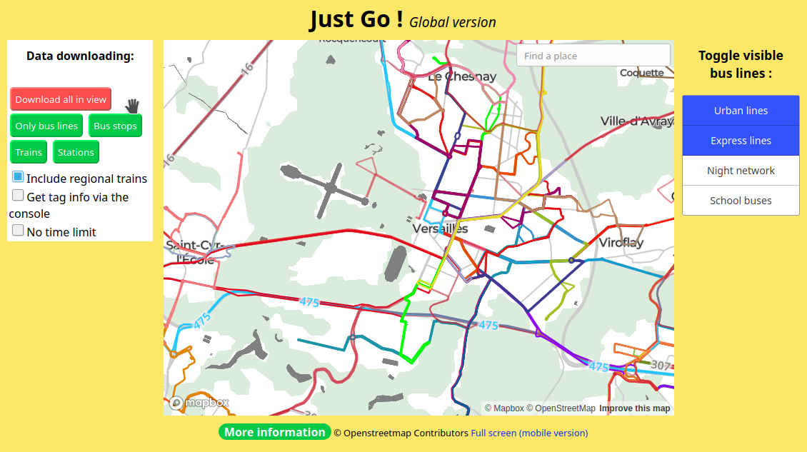
- [1] clementroux introduces a new service that visualises public transport data from OSM. The service, named JustGo, also provides downloads of public transport data.
- The map of security cameras installed by the Moscow (Russia) City Hall uses OSM as a background. The installation addresses are marked with dots on the map, and there may be even more cameras.
Open Data
- David Morais Ferreira (osm user dmlu) shows how to build shaded relief maps, using Luxembourg open data as an example.
Licences
- MapBox highlighted the creativity of many local projects helping in the COVID-19 response using MapBox products. Nuno Caldeira is watching to ensure the recognition of the OpenStreetMap community role in all these efforts.
Software
- An article on Medium explains how Google’s OR-Tools can be used to solve vehicle routing problems. Other tools directly based on OpenStreetMap are also mentioned, both for routing and optimisation.
- Hannah Judge, from Mapbox, likes that Sheet Mapper, a tool that creates live maps including an OSM attribution with POI data from a spreadsheet, is included on Mapbox’s new Impact Tools page.
- Mapzen, a start-up which failed early in 2018, created a lot of useful software in the OSM sphere. The Mapzen open-source, MIT licensed, mapping platform has moved to the Urban Computing Foundation (UCF), founded by the Linux Foundation as an umbrella for the mobility sector, which wants to restart the project.
Releases
- Joseph Eisenberg blogged about the improvements made in OpenStreetMap Carto release v5.1.0. As usual, it will take some days until you can see the changes in the default map on the OSM website.
Did you know …
- … how to quickly and easily set up your own tile server?
- …the OSM Ireland Tasking Manager, which was set up to complete all of Ireland’s buildings in OSM as part of the #osmIRL_buildings campaign.
Other “geo” things
- Guillaume Rischard tweets that the dismantled fortress under Luxembourg City can still be detected when using newly released LiDAR open data.
- Map enthusiasts are tweeting images of maps (and map-related objects) which they have at home. The hashtag is #mapsathome.
- Another battle in the ongoing dispute as to the world’s steepest street was resolved in favour of New Zealand, according to The Guardian. We’ve reported on earlier episodes.
Upcoming Events
Many meetings are being cancelled – please check the calendar on the wiki page for updates.
Note: If you like to see your event here, please put it into the calendar. Only data which is there, will appear in weeklyOSM. Please check your event in our public calendar preview and correct it, where appropriate.
This weeklyOSM was produced by NunoMASAzevedo, Polyglot, Rogehm, SK53, Silka123, SunCobalt, TheSwavu, YoViajo, derFred.