04/04/2023-10/04/2023
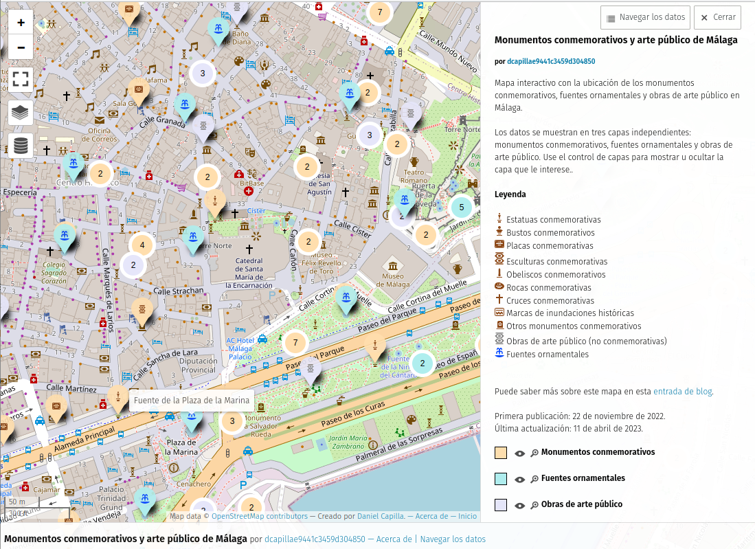
uMap of Monuments in Málaga [1] | © uMap Daniel Capilla © OpenStreetMap contributors
Mapping
- Do you want to add improvements to OSM while out in the field? AngocA’s blog post suggests
 > some apps that make this possible.
 - A thread on the German subforum discussed > how to map paths in
boundary=protected_areathat should be avoided by visitors in the winter.
 >
> 
 >
> Community
- [1] Daniel Capilla has added > a few more layers to his interactive map of monuments with the locations of ornamental fountains and public works of art in Málaga.
- Trufi Association is looking for a German-speaking Product Owner volunteer in the Hamburg area to promote their award-winning cycling app.
Events
- Because there is no global “State of the Map” event this year, OpenStreetMap Belgium has decided to set up a “State of the Map Europe” instead. The event will be in Antwerp, Belgium from Friday November 10th till Sunday November 12th. There will be space for 500 participants, with two main tracks, and the usual unconference part of the event. Online participation will be possible. Watch the website for further updates.
- Pete Masters is looking for suggestions for a new name for the HOT unSummit programme (there is too much confusion with the United Nations!). Token of appreciation is available, if your suggestion is chosen! Deadline 16 April.
- The key dates for SotM 2024 have been published. Venues can apply.
OSM research
- Members of HeiGIT are using gamification tools with the crowdsourcing MapSwipe mobile application to assess building completeness. OSM offers great potential to assess risk at a detailed building-by-building level, however, the completeness of OSM building footprints is still heterogeneous. This approach with MapSwipe is presented in a paper now.
Maps
- LaoshuBaby tweeted a video about how Facebook Segment Anything works on satellite imagery. The model was published on GitHub.
Software
- OpenStreetMap BaWü names (via Mastodon) the OSM apps that are already available on HarmonyOS (the OS from Huawei): OsmAnd, MapFactor, MAPS.ME, Naviki, Navmii, and Komoot.
- Achim Domma has pointed out a tweet by Katharina Nocum. In this tweet, the publicist and net activist complains that pedestrian routing wants to route her through an unlit park at 3 am. Manfred Reiter takes up the problem (in Mastodon) and refers to possibilities of improving the data through Mapathons, organised mapping like the UK quarterly project, or MapRoulette. He directly addresses the publishers of OsmAnd and Graphhopper. It will be interesting to see which app tackles this problem first, or whether Organic Maps will come out on top.
- Organic Maps reports on many new features in its 2023-04-06 release.
- News from Organic Maps reported on Mastodon. Android users can test the experimental lanes suggestion while driving. Navigation directions should display correctly on iPads now.
Programming
- Sarah Hoffmann reports on her progress with using Python for reverse geocoding on Nominatim instead of PHP.
OSM in the media
- Regional Belarusian website S13 reprints > an interview given to the corporate newsletter of the local energy grid operator by Siarhiej Dudzinski, a mapper from Hrodna, Belarus.
 >
> Other “geo” things
- Ukrainian cartographer and OpenStreetMap contributor Fedir Gontsa created detailed 3D plans of colonies on Mars. He used real data of the Martian terrain obtained by the Mars Global Surveyor unmanned research spacecraft. Open source software was used for the project.
- Ulrich et al. proposed an approach of high-resolution estimation of traffic emissions in their paper. It is based entirely on open data, such as, the road network obtained from OSM, and can be applied to other research areas within Germany with a little additional effort.
Upcoming Events
| Where | What | Online | When | Country |
|---|---|---|---|---|
| Southeast | FOSSASIA | 2023-04-12 – 2023-04-14 | sg | |
| Localidad Usaquén | GeoBeer – Reunámonos con una cerveza para hablar de OpenStreetMap | 2023-04-14 |  | |
| Jaro | #MapaTime with Central Phillippines University, Iloilo | 2023-04-14 |  | |
| Grenoble | Mapathon CartONG | 2023-04-14 |  | |
| Berlin | OSM Stammtisch Berlin/Brandenburg | 2023-04-14 |  | |
| Berlin | OSM Hackweekend Berlin 04/2023 | 2023-04-15 – 2023-04-16 | | |
| Roma | Betül ışıl Dal | 2023-04-15 – 2023-04-21 |  | |
| Roma | Betül ışıl Dal | 2023-04-15 – 2023-04-21 | | |
| 烏日區 | 悠閒漫步in台中綠線考察團-202304 | 2023-04-15 |  | |
| Toulouse | Réunion du groupe local de Toulouse | 2023-04-15 | | |
| Caen | Carto Party Vélo | 2023-04-15 | | |
| Rio de Janeiro | Mapeamento com OpenStreetMap | 2023-04-15 |  | |
| Hannover | OSM-Stammtisch Hannover | 2023-04-17 | | |
| Grenoble | Atelier adressage dans OpenStreetMap | 2023-04-17 | | |
| 6th Annual Humanitarian Mapathon / 6. jährlicher humanitärer Mapathon / 第6回ヒューマン・マパソン | 2023-04-18 – 2023-04-20 | |||
| OSMF Engineering Working Group meeting | 2023-04-18 | |||
| Lyon | Réunion du groupe local de Lyon | 2023-04-18 | | |
| Bonn | 162. Treffen des OSM-Stammtisches Bonn | 2023-04-18 | | |
| Lüneburg | Lüneburger Mappertreffen (online) | 2023-04-18 | | |
| Formação UN Mappers: OpenStreetMap e o mapeamento humanitário – sessão 5 | 2023-04-19 | |||
| HOT Open Tech and Innovation WG | 2023-04-19 | |||
| Berlin | Missing Maps – DRK & MSF Online Mapathon | ✓ | 2023-04-19 | |
| Zürich | Missing Maps Zürich Mapathon | 2023-04-19 |  | |
| Roma | Betül ışıl Dal | 2023-04-20 – 2023-04-21 | | |
| Roma | Betül ışıl Dal | 2023-04-20 – 2023-04-21 | | |
| iD monthly meetup | 2023-04-24 | |||
| Bremen | Bremer Mappertreffen (Online) | ✓ | 2023-04-24 | |
| Leipzig | Leipziger OSM-Stammtisch | 2023-04-25 | | |
| San Jose | South Bay Map Night | ✓ | 2023-04-26 |  |
| Formação UN Mappers: OpenStreetMap e o mapeamento humanitário – sessão 6 | 2023-04-26 | |||
| Écully | Mapathon de l’Ecole Centrale de Lyon | 2023-04-26 | | |
| Düsseldorf | Düsseldorfer OpenStreetMap-Treffen | 2023-04-26 | | |
| Roma | Incontro dei mappatori romani e laziali | 2023-04-26 | | |
| Brest | #Rendez-vousInfini – Cartes personnalisés | 2023-04-28 | |
Note:
If you like to see your event here, please put it into the OSM calendar. Only data which is there, will appear in weeklyOSM.
This weeklyOSM was produced by SK53, SomeoneElse, Strubbl, TrickyFoxy, barefootstache, darkonus, derFred, rtnf.
We welcome link suggestions for the next issue via this form and look forward to your contributions.