02.05.–08.05.2023
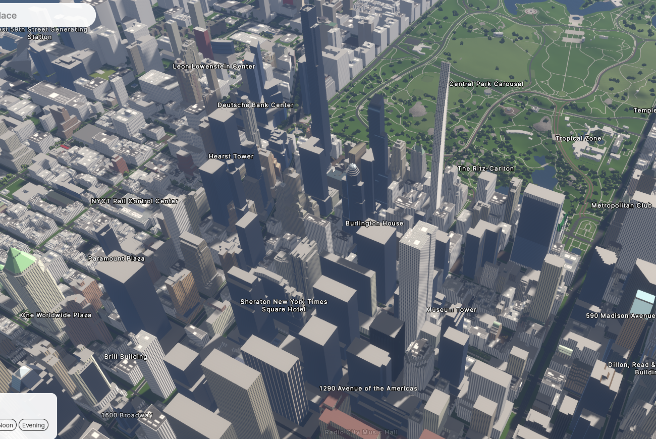
Streets GL – vykresluje mapu ve 3D a aktuálního času [1] | ⓘ Mapbox © powered by Esri | © přispěvatelé OpenStreetMap
OSM CZ
- Problém s konektivitou přes IPv6 pro web osmap.cz / openstreetmap.cz.
- Problematické poštovní schránky minimálně v depech Jihlava a Česká Třebová.
- Pro body záchrany doplněna funkce pro body značené jako
removed:. - Žádost o možnost konzultace problematiky popisných, orientačních a evidenčních čísel pro budovy v České republice.
- Aktualizace stavu tříděného odpadu.
- Spratek informuje o zprovoznění uMapy s autobusovými zastávkami pro Jihočeský kraj.
- Jak je to s používáním nového tagu
crossing:markingspro mapování přechodů pro chodce? - Informace o dalších plánovaných editacích firmy TomTom v datech OSM v České republice.
OSM SK
- Jak zabránit automatickému posunu mapy při kreslení v editoru JOSM?
- Je možné si, z nějaké vrstvy ZBGIS nebo katastru, zobrazit linii plynovodu v editoru JOSM?
- Informace o aktualizaci ortofoto mozaiky pro východ Slovenska na freemap.sk.
Mapování
- Po workshopu pořádaném mappery OSN se skupina studentů z programu Erasmus Mundus Masters na oboru GIS technologií na Univerzitě v Jaume ve španělském Castellón de la Plana rozhodlo analyzovat bezpečnost kampusu a objevili potenciální problémy díky mapování pouličního osvětlení v OSM.
- PhysicsArmature má několik tipů pro mapování řek a jak to dělat jednoduše.
- Valerie Norton napsala článek kde se zabývá různými tagy spojovanými s úvazišti a odpočívkami pro jezdecké stezky. Zkoumá využití a popularitu tagů jako jsou
amenity=hitching_post,tourism=trail_riding_rest,amenity=animal_hitchneboamenity=horse_parking. Autorka přemýšlí nad výhodami jednotlivých tagů, jejich hierarchické struktuře a zdůrazňuje potřebu jasnějších pravidel a doplňujících tagů pro zvýšení přesnosti mapování.
Mapovací kampaně
- Marjan Van de Kauter z týmu OSM v rámci firmy TomTom oznámil jejich plán na provádění editací v Lucemburském vévodství. Podkladem je zpětná vazba pro jejich plánovanou novou mapu a ujišťují, že editace zlepší OpenStreetMap a nebudou v konfliktu s nedávnými editacemi od komunity. Tým se hodlá pro začátek zaměřit na editaci silnicí, adres, bodů zájmu, využití půdy, budovy a vodní plochy. Pro editace budou využívat hashtagy
#tomtoma#tt_mapfeedbackaby bylo možné sledovat postup prací a zároveň pro tyto své aktivity vítají zpětnou vazbu od komunity.
Komunita
- Ve spojitosti s dotazníkem ohledně komunikace komunity OSM (psali jsme minule) se Imre Samu rozhodl objasnit kulturní odlišnosti v komunikaci v různých zemích. Cituje ze svých zdrojů a podložil svá tvrzení třemi odkazy, která by si měl přečíst každý, kdo vstupuje na mezinárodní scénu.
- mapmeld bloguje o hranici belgického Baarle-Hertogu a holandského Baarle-Nassau, které se překrývají v jednom městě plném hraničních přechodů a enkláv. Přiložil fotografie nejpodivnějších míst, včetně budov, kterými hranice přímo prochází.
- Sango Bishiri Narcisse z afrického Čadu je mapperem měsíce OSN za květen.
Nadace OpenStreetMap
- Rada Nadace OpenStreetMap zve své členy i další zájemce z řad komunity OSM na účast na revizi svého strategického plánu. Cílem je o něm diskutovat ve čtyřech fázích během následující dvou měsíců. V první bude zaměření na „Cluster B: Rozvoj komunity pro OSM“. Rada žádá zpětnou vazbu hlavně ohledně chybějících prvků, nekonzistence plánu, urgentních problémů a dalších bodů důležitých pro úspěch a růst OpenStreetMap. Komentáře lze sdílet na komunitním fóru OSM nebo mail listu či zaslat osobní zpětnou vazbu jednotlivým členům rady.
- Rada Nadace OSM připravila návrh pravidel pro peněžní sbírky a žádá komunitu o zpětnou vazbu. Tu lze poskytnout na komunitním fóru, v komentářích na blogu nebo přímo členům rady.
Vzdělávání
- Denrazir Atara z HOT Open Mapping Hub Asia-Pacific pořádá v neděli 14. května online školení pro začátečníky i zkušené mappery na téma používání nástroje uMap.
Výzkum OSM
- Ulrich a kolektiv studují potenciál OSM pro kvantifikaci změn využití půdy v souvislosti s vypouštěním uhlíku do atmosféry v rámci regionálních studií. V jejich novém článku takto zkoumají německý spolkový stát Bádensko-Württembersko.
Mapy
- [1] Streets GL je působivý renderer 3D map v reálném čase navržený pro demonstraci dat OpenStreetMap s úžasnými vizuálními efekty. Tento projekt v jazyce TypeScript využívá WebGL2 a implementaci vykreslování grafů pro generování dynamické geometrie, což dovoluje vizualizaci komplexních tvarů budov, silnic, stromů a dalších objektů.
- karlos na platformě Mastodon upozorňuje na to, že přestože týdeník WeeklyOSM nabízí obsáhlý seznam událostí, chybí zde mapa pro vizualizaci, kde k nim došlo. Sdílí testovací mapu nabízející body se zajímavými událostmi. Widget pro kalendář od Jonathana Beliëna ukazuje, jak by to mohlo vypadat.
Otevřená data
- Jeff Underwood tweetuje o nedávných vylepšeních dat o výškách budov v centru amerického města Phoenix a srovnává dostupné informace v datech OpenStreetMap a Overture. Oceňuje pozitivní rozvoj a všímá si, že pokrytí dat od Overture jde i mimo centrum města a pokrývá celý region.
Software
- Nástroj od skupiny Bellingcat pro geolokaci postavený na datech OpenStreetMap zjednodušuje proces identifikace pozice snímku pro investigativní účely. Výběrem klíčových prvků snímku jako jsou významné krajinné prvky nebo struktury mohou uživatelé zúžit možnosti při hledání v rámci specifikované oblasti. Nástroj nabízí seznam potenciálních shod na mapě, což umožňuje uživatelům vybrat přesné místo pro další zkoumání. S pomocí tohoto nástroje se tak geolokace snímků stala mnohem přístupnější pro výzkumníky či investigativní novináře, kteří pracují s otevřenými zdroji.
- Wille Marcel během akce OpenStreetMap US Mappy Hour představil nástroj OSMCha pro analýzu a kontrolu kvality dat OpenStreetMap. Průvodce se, počínaje časem 5:14, zabývá různými funkcemi, což nabízí cenný zdroj pro nadšence do OSM.
Nová vydání
- Magic Lane zveřejnili novou verzi jejich navigační aplikace pro Android jménem Magic Earth, která nabízí uživatelům soukromí, možnosti provozu offline a pokročilých pomůcek pro řidiče.
Věděli jste …
- … o otevřené etymologické mapě? Jedná s o webovou aplikaci pro zobrazování historických informací o lidech, jejichž jména posloužila při pojmenování ulic nebo míst. Aplikace používá informace z tagu
wikidata:*v datech OSM. - … že je vhodné použít Ctrl+F5 namísto pouhého F5 pokud chcete obnovit webovou stránku? Ziltoidium připomíná
 , že pokud po editaci stisknete pro obnovení mapy jen F5, tak se sice načte stránka znovu, ale použijí se obrázky z lokální cache prohlížeče. Doporučuje tedy zvyknout si používat kombinaci Ctrl+F5. Změny mapových vrstev na osm.org jsou pak viditelné po cca 1-2 minutách. Jiné mapové vrstvy mohou být občerstvovány méně často.
 , že pokud po editaci stisknete pro obnovení mapy jen F5, tak se sice načte stránka znovu, ale použijí se obrázky z lokální cache prohlížeče. Doporučuje tedy zvyknout si používat kombinaci Ctrl+F5. Změny mapových vrstev na osm.org jsou pak viditelné po cca 1-2 minutách. Jiné mapové vrstvy mohou být občerstvovány méně často.
OSM v médiích
- Výzkumníci z univerzity Simona Frasera vytvořili první kanadskou otevřenou datovou sady cyklistické infrastruktury. Jejich cílem je propagovat aktivní možnosti dopravy a pomoci osobám s rozhodovací pravomocí. Tato datová sada je odvozena z dat OpenStreetMap a nabízí konzistentní informace o cyklistické infrastruktuře, což dovoluje lepší rozhodování při plánování.
- V rozhovoru o Lower Saxony Tourism Network se Marie Witte z Mittelweser-Touristik (MWT) zmínila ► o užitečnosti spolupráce s mappery OSM pro optimalizaci cyklistických a turistických tras s využitím digitálních map. Pro realizaci této spolupráce se MWT společně s Tof99 a OSM_RogerWilco rozhodli sestavit pracovní skupinu ve které si mappeři a experti na turistiku vyměňují informace. Spolupráce umožnila MWT ► díky mapperům OSM vylepšit své návrhy a zajistit kvalitu dat pro trasy.

Plánované události
| kde | co | online | kdy | země |
|---|---|---|---|---|
| Salt Lake City | OSM Utah Monthly Map Night | 11.05.2023 |  | |
| Chippewa Township | OpenStreetMap Michigan Meetup | ✓ | 11.05.2023 | |
| “Open- und OpenStreetMap-Daten in Blaulichtorganisationen” (Schweiz) | 11.05.2023 | |||
| Berlín | 179. Berlin-Brandenburg OpenStreetMap Stammtisch | 11.05.2023 |  | |
| Curych | OSM-Stammtisch | 11.05.2023 |  | |
| Zaragoza | esLibre 2023 | 12.05.–13.05.2023 |  | |
| Briançon | Parlons d’OpenStreetMap | 12.05.2023 |  | |
| Verona | MERGE-it | 12.05.–13.05.2023 |  | |
| Gap | Parlons d’OpenStreetMap | 12.05.2023 | | |
| Sülysáp | Mapping around Sülysáp before, after and during breaks of qbParty (demoscene) | 13.05.–14.05.2023 |  | |
| Gap | Cartopartie Durance à vélo dans le pays Gapençais ! | 13.05.2023 | | |
| Vincent | Social Mapping Saturday: Hyde Park | 13.05.2023 |  | |
| Nanterre | Paris Hack Weekend | 13.05.–14.05.2023 | | |
| Puerto López | Notas OSM: Discutamos hashtags para incluir en las notas de OpenStreetMap | 13.05.2023 |  | |
| Singapore | OG Training by HOTOSM Ap-Hub | CREATING ONLINE MAPS USING UMAP | 13.05.2023 | |
| Kodaň | OSMmapperCPH | 14.05.2023 |  | |
| Grenoble | Contribuez à OpenStreetMap avec votre smartphone | 15.05.2023 | | |
| 臺北市 | OpenStreetMap x Wikidata 月聚會 #52 | 15.05.2023 |  | |
| Lyon | Réunion du groupe local de Lyon | 16.05.2023 | | |
| Bonn | 163. Treffen des OSM-Stammtisches Bonn | 16.05.2023 | | |
| Edinburgh | OSM Edinburgh Social | 16.05.2023 |  | |
| Lüneburg | Lüneburger Mappertreffen (online) | 16.05.2023 | | |
| Formação UN Mappers: OpenStreetMap e o mapeamento humanitário – sessão 9 | 17.05.2023 | |||
| Curych | Missing Maps Zürich Mapathon | 17.05.2023 | | |
| Karlsruhe | Stammtisch Karlsruhe | 17.05.2023 | | |
| Washington | OSM US Mappy Hour | ✓ | 18.05.2023 | |
| Rīga | State of the Map Baltics 2023 | 17.05.–18.05.2023 |  | |
| Toulouse | Réunion du groupe local de Toulouse | 20.05.2023 | | |
| Singapore | OG Training by HOTOSM AP-Hub | CREATING ONLINE MAPS USING USHAHIDI | 20.05.2023 | |
| Brémy | Bremer Mappertreffen (Online) | ✓ | 22.05.2023 | |
| San Jose | South Bay Map Night | ✓ | 24.05.2023 | |
| Bayonne | Cartopartie à Bayonne – 25 mai 2023 | 25.05.2023 | | |
| Singapore | OG Training by HOTOSM AP-Hub | OSM ON THE GO: OSM MOBILE APPLICATIONS | 27.05.2023 |
Poznámka: Pokud zde chcete vidět vaši akci
Návrhy na zajímavé odkazy pro příští čísla nám můžete poslat zde a podělit se tak o ně s našimi čtenáři.
Toto číslo přeložil tom.k a redakčně upravil mkyral. Budeme velmi rádi, pokud podpoříte a oceníte naši práci tím, že budete dílo dále šířit, např. sdílením na sociálních sítích (like, retweet, boost…). Předem za to děkujeme.
Každé číslo v CZ verzi je promováno zde: @osmcz |
  @osmcz |
  Talk-cz | osm_sk |
  rss
rss
Můžete nás kontaktovat e-mailem:  weekly@openstreetmap.cz
Originál tohoto souhrnu připravili: MatthiasMatthias, Strubbl, TheSwavu, barefootstache, darkonus, derFred, isoipsa, rtnf.
Ctrl-F5 has no effect in Firefox (using Linux). Ctrl-Shift-R, however, does.
@Alex Ctrl-F5 does override the cache on Linux (or at least it does in the Debian flavours). There is a list of keyboard shortcuts for Firefox available on https://support.mozilla.org/en-US/kb/keyboard-shortcuts-perform-firefox-tasks-quickly.