12/09/2023-18/09/2023
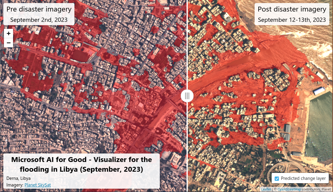
Before and after the floods in Libya [1] © Microsoft @ Planet Sky | map data © OpenStreetMap contributors
Mappatura
- Citrula ha scritto
 > su come utilizzare la funzione di feed RSS e il filtro di OSMCha per esaminare i changeset di cui è stata richiesta la revisione.
 - b-unicycling sta lavorando > a una proposta:Vandalizzato.
 >
> 
Comunità
- Il mappatore di OpenStreetMap Jasper voleva > una maglietta OSM, ma non c’era. Così ne ha realizzata una e la offre > su etsy, nel caso tu sia interessato.
- nabilersyad scrive sul blog > del suo obiettivo di mappare ogni strada del CBD di Kuala Lumpur e di aggiungere dati visibili via satellite in tutto il distretto di Kuala Selangor.
- Ci sono 30 video del SotM US 2023 su YouTube > .
- Antti scrive sul blog > come utilizzare OsmAnd per guidare un TET (Trans Euro Trail) – un percorso GPX di 80.000 km dai confini dell’Africa al Circolo Polare Artico creato dalla comunità di motociclisti d’avventura TET.
OpenStreetMap Foundation
- È possibile consultare > lo stato attuale della campagna di raccolta fondi dell’OSMF. Anche i rispettivi commenti sono interessanti.
- Sei invitato a partecipare > alla prossima videoconferenza mensile del consiglio dell’OSMF che si terrà giovedì 28 settembre alle 15:00 UTC > . La sala video aprirà 20 minuti prima dell’inizio della riunione. L’ordine del giorno preliminare è disponibile sul wiki > , dove verrà aggiunta anche la bozza del verbale.
- OpenStreetMap Foundation segnala > l’aggiunta di un server di rendering > negli Stati Uniti. Verrà utilizzato per il rendering e l’aggiornamento dello stile predefinito delle mappe.
OSM e l’azione umanitaria
- [1] Pete Masters (pedrito1414), Responsabile della Comunità di HOT, ha scritto > un aggiornamento sulle attivazioni di risposta ai disastri in Marocco e Libia, fornendo statistiche e altre informazioni su questa risposta.
- ABDURAHMAN AL FURJANI di OSM Libia, con il supporto di UN Mappers e HOT, ha lanciato un’attivazione > di mappatura di emergenza in seguito alle devastanti inondazioni di Darnah, in Libia. Ci sono attività > di mappatura che richiedono il tuo intervento sul Tasking Manager di HOT e immagini > pre e post evento disponibili su OpenAerialMap, fornite da Maxar.
Mappe
- Imzadi1979 annuncia > che la comunità responsabile delle voci stradali della Wikipedia inglese sul Nord America ha creato un fork di Wikipedia > che presenta mappe vettoriali > basate su OpenStreetMap Americana > (esempio > ).
- La mappa del ristoro di Berlino mostra le aree fresche, ventose e ombreggiate della città. La mappa è stata creata in collaborazione tra l’Open Data Informationsstelle Berlin > e CityLab Berlin > .
- Geofabrik ha rilasciato > una correzione dei confini dell’istantanea dei dati OpenStreetMap per la regione delle Alpi.
- jonnymccullagh tiene un blog sulla creazione di un server di mappe che mostra i nomi dei luoghi in lingua irlandese (Gaeilge).
 >
> Open Data
- L’applicazione web interattiva > di Qiusheng Wu per la visualizzazione dei Maxar Open Data è stata migliorata. Cliccando semplicemente sulla mappa, ora puoi selezionare le immagini in modo interattivo.
Software
- jarmokivekas propone su github uno strumento di panoramica che ha sviluppato per tracciare l’attività del tasking manager per campagna, progetto, paese o organizzazione. Si tratta di una versione preliminare. Non è ancora chiaro quanto sarà facile lavorare con questa API (senza elenco a discesa per la selezione) rispetto a lavorare direttamente nella funzione Esplora del Tasking Manager.
- Answerquest elenca > i passaggi per convertire gli shapefile dei confini con Mapshaper e QGIS al fine di utilizzarli per Openstreetmap.
- Allan Mustard ha scoperto come fare in modo che mkgmap produca file IMG compatibili con Garmin e completamente personalizzati per il suo navigatore GPS nüvi. Ha pubblicato > un tutorial per consentire anche a te di produrre file IMG personalizzati secondo le tue specifiche.
- Dopo oltre 9 anni di lavoro, un gruppo di studenti del Collegio Salesiano di Duitama (Colombia) ha lanciato > l’applicazione mobile chiamata ‘BusBoy.app’, già disponibile su Google Play Store e presto anche su App Store. I creatori cercano > di espandere l’uso dell’applicazione in modo che sempre più utenti del trasporto urbano conoscano i nomi dei percorsi, i luoghi di viaggio, i punti di interesse, le compagnie di trasporto e gli orari, tra gli altri.
- MapComplete ha cambiato > il suo dominio internet da mapcomplete.osm.be a mapcomplete.org dopo un breve sondaggio effettuato sul server mastodon en.osm.town
- F-droid ha aggiunto > il successore di Geopaparazzi, SMASH, al repository. Il maintainer di SMASH e F-droid hanno scelto la compilazione riproducibile, per garantire che i pacchetti di installazione pubblicati su F-droid e su GitHub upstream sono identici e che nessuno dei due può essere infettato da malware.
- Sam Woodcock offre > una panoramica di alto livello del Field Mapping Tasking Manager (FMTM), un software per coordinare le attività di mappatura sul campo.
- vorpalblade segnala > che il plugin JOSM MapWithAI ora supporta PMTiles e Mapbox Vector Tiles come fonti di dati e mostra come utilizzarlo. PMTiles è un formato di archiviazione di tiles web-first che consente al fornitore di avere un unico file con tutte le tiles che desidera condividere.
 >
> Programmazione
- Una famiglia australiana si è rifiutata di vendere il proprio terreno agricolo, nonostante l’intero quartiere sia stato trasformato in un nuovo complesso residenziale. L’ubicazione era sconosciuta.Questa sfida è stata raccolta > da Dean Marchiori per localizzare – come scrive lui stesso – la proprietà più strana di Sydney utilizzando osrm e l’API Overpass. Un bel “filmato” alla fine dell’articolo.
- Sam Woodcock offre > una panoramica dei diversi formati di file di tiles vettoriali e delle loro differenze.
Lo sapevi che…
- … puoi esplorare luoghi su OpenStreetMap utilizzando l’applicazione OpenStreetBrowser?
- … puoi partecipare a OSMFight?
Altre cose “geo”
- Felix von Leitner > , un esperto tedesco di sicurezza informatica commenta l’attualità su https://blog.fefe.de > . Il nostro concorrente di mercato sta cercando > volontari per registrare le strade per lui. Felix chiede ironicamente di rispondere a questa domanda sul suo blog: “Anche tu stai pensando di fare il volontario per la quarta azienda più ricca del mondo? Spero di no. Ma se lo stai facendo, è meglio che ti offra come volontario per Openstreetmap”.
Prossimi eventi
| Dove | Cosa | Online | Quando | Nazione |
|---|---|---|---|---|
| Rouen | Rencontre Groupe local Rouen | 2023-09-22 |  | |
| Saint-Barthélemy-de-Séchilienne | Mapping Party in Saint-Barthélemy-de-Séchilienne 38220 France | 2023-09-23 | | |
| Localidad Teusaquillo | Bici Ruta Geek en Bogotá | 2023-09-24 |  | |
| Град Кикинда | OpenStreetMap x Pionir #2 | 2023-09-24 |  | |
| Maricá | Mapathon – Maricá City | 2023-09-24 – 2023-09-30 |  | |
| Chambéry | Mapathon débutant saison 23/24 CartONG | 2023-09-25 | | |
| Gent | OpenStreetMap meetup | 2023-09-26 |  | |
| Delft | IHE Delft / HOTOSM – IHEUrgentAction Mapathon for Morocco and Libya | 2023-09-26 |  | |
| San Jose | South Bay Map Night | ✓ | 2023-09-27 |  |
| Berlin | Missing Maps Mapathon Berlin | 2023-09-27 |  | |
| London | London pub meet-up | 2023-09-27 |  | |
| Aachen | 4. Treffen Aachener Stammtisch 2.0 | 2023-09-28 | | |
| Lübeck | 135. OSM-Stammtisch für Lübeck und Umgebung | 2023-09-28 | | |
| Düsseldorf | Düsseldorfer OpenStreetMap-Treffen | 2023-09-29 | | |
| Curitiba | Pré-Conferência – State of the Map Brasil 2023 | 2023-09-30 | | |
| Karlsruhe | Karlsruhe Hack Weekend September 2023 | 2023-09-30 – 2023-10-01 | | |
| Portland | A Synesthete’s Atlas + Some 3d Color/Light/Motion Experiments | 2023-10-02 | | |
| Curitiba | State of the Map Brasil 2023 🙂 | 2023-10-02 – 2023-10-04 | | |
| Missing Maps London Mapathon | 2023-10-03 | |||
| OSMF Engineering Working Group meeting | 2023-10-04 |
Nota: Se vorresti vedere qui elencato il tuo evento, per favore inseriscilo nel calendario. Solo i dati che sono inseriti lì appariranno nel notiziario.
Questa Notiziario Settimanale OSM è stato prodotto da MatthiasMatthias, Michael Montani, PierZen, Strubbl, derFred, isoipsa.