26/09/2023-02/10/2023
Map style "Streetscape Map" [1] © Alex Seidel aka Supaplex030 | map data © OpenStreetMap contributors
Mapping
- Anne-Karoline Distel blogged about mapping Martello towers.
- KlausG reported
 ► on how he had to deal with the direction of validity and the direction of view when tagging road signs and using the
 directiontag. When indicating a cardinal direction, e.g. withdirection=E(for east), the direction is indicated in which the sign is facing – and this is usually opposite to the direction of the road. - Valerie Norton explained some of the alternative data sources they use to map hiking trails on OpenStreetMap.
The following proposals are waiting for your comment:
cycleway=waiting aidto map street furniture and devices for cyclists that are intended to make waiting, especially at traffic lights, more comfortable.historic=millstoneto map a large round stone used for grinding grain.
 ►
►
Community
- Gloria del Puerto, from Paraguay, is the UN Mapper of the month for October.
- OpenStreetMap Belgium has announced its October 2023 Mapper of the Month: Lorenzo Stucchi.
- gvwaa blogged on how they systematically mapped the public bookcases in the Greater Longfellow community of Minneapolis.
- Koreller blogged on how he motivated himself to map Pyongyang, an urban area 15 km wide by 12 km long. It took over a year, from April 2022 to May 2023, to finish this project, particularly adding buildings and roads.
- mstock explained the workflow of the Programme Committee – Global State of the Map team.
- OpenStreetMap asked, on Mastodon, for pictures of your preferred map style. Your answer is still missing 😉
Local chapter news
- OpenStreetMap US announced that AllTrails, a social networking platform for outdoor enthusiasts, has joined as an OpenStreetMap US Supporter Member.
Events
- On Friday 29 September the DevSeed team, at its office in Ayacucho 🇵🇪, conducted a workshop on OpenStreetMap mapping with the participation of students and professionals from different public and private entities in Ayacucho, Peru.
 a workshop on OpenStreetMap mapping with the participation of students and professionals from different public and private entities in Ayacucho, Peru.
Humanitarian OSM
- IHE Delft, in collaboration with HOT, has organised a mapathon to map areas affected by the Moroccan earthquake and Libyan floods.
Maps
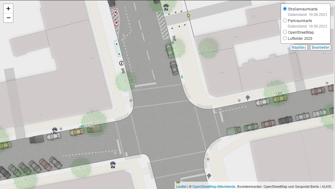
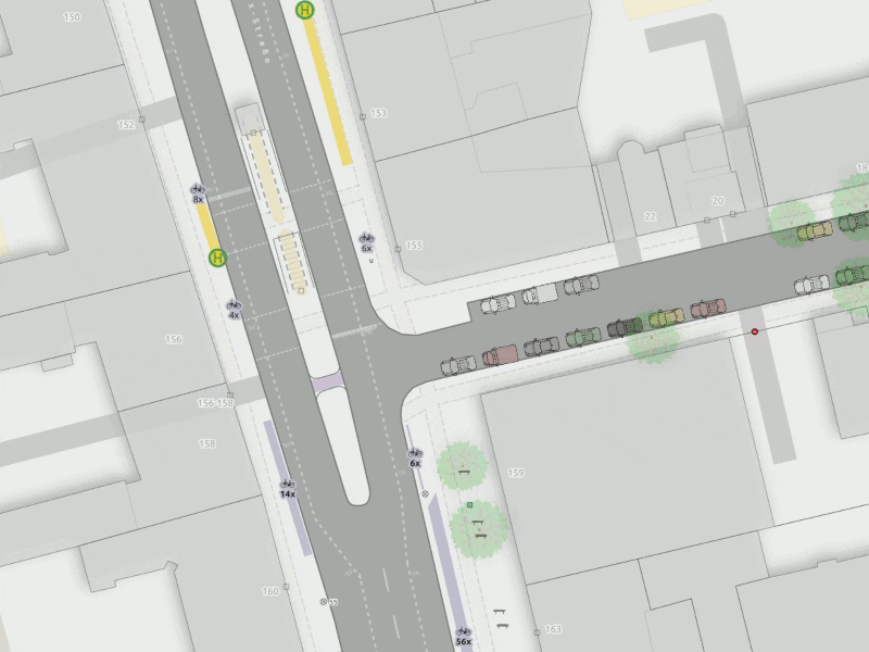
- [1] Alex Seidel, aka Supaplex030, tooted that the map style for the ‘Streetscape Map’ (a detailed map based on OpenStreetMap that focuses on the urban landscape and the spatial design of public and street space) is now available ► on GitHub. Alex has also published an impressive example from Neukölln, a district of Berlin. (We reported earlier with a gif in issue 598 of January 2022.)
- Igor Sukhorukov has analysed, with his tool openstreetmap_h3, the neighbourhoods of Berlin ►, Moscow ►, and several other cities to see if they are attractive to live in.
- James Killick reviewed how well several map making applications ranging from Esri, Google My Maps, Felt, to Microsoft Excel could map an address list. Meanwhile, Oliver Roick commented on this review.
 ►
►
OSM in action
- Times change. So do our categories from time to time. ‘Switch2OSM’ is now ‘OSM in action’. In this category we want to point out examples of the use of OSM data. Feel free to recommend such or similar applications to our readers.
A good first example is the GPS Hiking Atlas
► . It is a free travel guide that also handles ► the OSM licence conditions correctly. - caos has published ► a non-representative survey on the use of navigation apps, on GNU/Linux.ch.
Software
- David Larlet presented the new permissions feature of uMap, which can be set for individual layers. This will help people who have contributive maps to set up a stable/fixed base layer. Further, it allows for even more control over which objects can be edited.
Programming
- Manish Mehra has written a tutorial on how to build a real-time location sharing app.
- Jacek Galowicz explained how to configure the OpenStreetMap rendering server on the NixOS operating system.
- Mikhail Sarafanov shared ► how to use OSM data to select a threshold value of Normalised Difference Vegetation Index (NDVI), derived from Landsat data, in order to identify green zones in cities.
Releases
- Frederik Ramm reported that the Geofabrik regional taginfo servers have been updated to the latest version. This latest version now includes a chronological report feature to see the progress of tag usage.
- The September 2023 version of Organic Maps has been released.
Did you know …
- … onlmaps, mapologies, and TerribleMaps have a social media presence on Mastodon?
- … that you can open and edit GPX files online using gpx.studio?
- … the Mastodon hashtag mappromptmonday?
Other “geo” things
- OpenCage has released the German edition of their
#geoweirdnessgeography trivia series. - James Killick introduced Mappedin Maker, a web application that can automatically convert building floor plans into indoor maps.
Upcoming Events
| Where | What | Online | When | Country |
|---|---|---|---|---|
| Bengaluru | OSM Bengaluru Mapping Party | 2023-10-07 |  | |
| Philadelphia | Bobby Zankel’s Wonderful Sound, Upholstery & Veronica Mercedes Jurkiewicz/Carlos Santiago/Matt Engle/Eric Theise : A Benefit for Fire Museum Presents | 2023-10-08 |  | |
| Phường Quán Thánh | OSM Vietnam weekly meeting | 2023-10-07 |  | |
| City Of Gosnells | Social mapping Sunday: Beckenham | 2023-10-08 |  | |
| København | OSMmapperCPH | 2023-10-08 |  | |
| Washington | A Synesthete’s Atlas: Cartographic Improvisations Between Eric Theise, Jim Ryan, and Darien Baiza / Tangent Universes | 2023-10-09 | | |
| Chambéry | Mapathon débutant saison 23/24 CartONG | 2023-10-09 |  | |
| HOT Mapathon: Libya Floods 2023 | 2023-10-10 | |||
| Osm2pgsql Virtual Meetup | 2023-10-10 | |||
| München | Münchner OSM-Treffen | 2023-10-10 |  | |
| San Jose | South Bay Map Night | ✓ | 2023-10-11 | |
| Abuja | State of the Map Nigeria 2023 | 2023-10-11 – 2023-10-14 | ng | |
| Brest | Rencontre groupe local | 2023-10-11 | | |
| Zürich | OSM-Stammtisch | 2023-10-11 |  | |
| Lorain County | OpenStreetMap Midwest Meetup | ✓ | 2023-10-12 | |
| Hannover | OSM-Stammtisch Hannover | 2023-10-12 | | |
| Montrouge | Rencontre contributeurs Sud de Paris | 2023-10-12 | | |
| Berlin | OSM Hackweekend Berlin 10/2023 | 2023-10-14 – 2023-10-15 | | |
| Henrietta Township | Journey to the Centers of Michigan | 2023-10-14 | | |
| Pittsburgh | A Synesthete’s Atlas: Cartographic Improvisations Between Eric Theise and Trē Seguritan Abalos | 2023-10-15 | | |
| Waitematā | FOSS4G SotM Oceania 2023 Conference | 2023-10-15 – 2023-10-19 |  | |
| 臺北市 | OpenStreetMap x Wikidata 月聚會 #57 | 2023-10-16 |  | |
| Berlin | Missing Maps – DRK Online Mapathon | 2023-10-17 | | |
| Bonn | 168. OSM-Stammtisch Bonn | 2023-10-17 | | |
| Lüneburg | Lüneburger Mappertreffen (online) | 2023-10-17 | | |
| OSMF Engineering Working Group meeting | 2023-10-18 | |||
| Zürich | Missing Maps Zürich Mapathon | 2023-10-18 | |
Note:
If you like to see your event here, please put it into the OSM calendar. Only data which is there, will appear in weeklyOSM.
This weeklyOSM was produced by MatthiasMatthias, PierZen, Strubbl, TheSwavu, TrickyFoxy, barefootstache, derFred.
We welcome link suggestions for the next issue via this form and look forward to your contributions.