01.11. – 07.11.2016
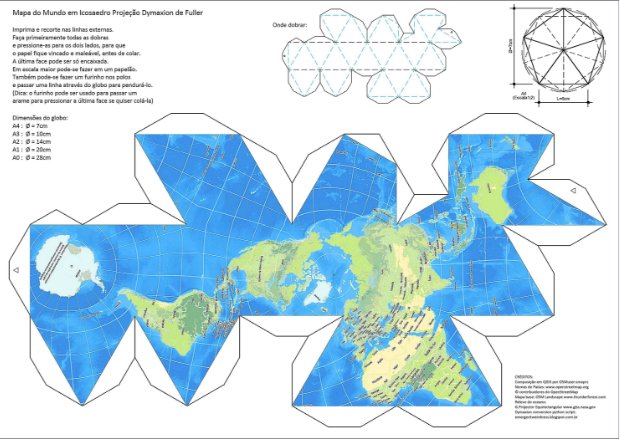 Mapa světa v projekci Dymaxion 1 | Sérgiův blog, soubor k tisku, vystřižení a slepení
Téma: Stav mapování turistických tras
Zajímá vás, jak se změnil stav turistických tras v České Republice? Splní se předpověď Mirka Suchého, že s koncem roku 2016 nebude co dělat? Naposledy v čísle 320 jsem popisoval aktuální stav projektů Taskmanu a kontroly na OsmHiCheck. Pojďme se nyní podívat, kam jsme se za dva měsíce posunuli.
U Taskmanu jsou definovány 3 projekty – pěší turistické značení KČT, cyklistické značení KČT a koňské stezky KČT. O koňské stezky ale bohužel není téměř žádný zájem, stále je zmapováno jen 8 dlaždic, stejně jako minule. Stejně tak je tomu u cyklotras, tam jsme stále na 0 dlaždicích. To na jednu stranu ukazuje malý zájem a/nebo propagaci těchto projektů, na stranu druhou nedochází k tříštění sil mezi mnoho souběžných úkolů jako se to stává u HOT (ano vím, existují priority úkolů). Dobrá zpráva je, že u pěších tras je vidět nějaký pokrok a to konkrétně posun z 65% na 68% tedy z 5101 na 5388 dlaždic. Když se podíváme do poslední historie, tak je vidět, že většinu tvoří (jak v poslední době tak celkově) uživatel Petr1868. Do konce roku se to tedy asi nestihne, ale nějaký posun vidět je.
Druhým projektem, který se snaží podpořit mapování turistických tras (primárně KČT) je pak OsmHiCheck. Zde je vidět, že aktuálně je v databázi 4412 relací turistických tras, z toho závažných chyb chyb na trasách (tedy těch, které tento program rozpozná) je minimum (něco přes 1%). U kontrol rozcestníků pak vidíme následující stav:
| stav k #320 | stav k #329 | |
| uzlů rozcestníků celkem | 17206 | 17801 |
| rozcestníků v pořádku | 5526 | 5985 |
rozcestníků bez fotky i bez ref | 8411 | 7076 |
rozcestníků bez fotky ale s ref | 4021 | 4701 |
K dispozici jsou opět grafické statistiky teď už za posledních 260 dnů trvání projektu. Tímto apeluji opět na autory fotek, aby zkusili projít fotky pod svým jménem, které systém nepoužil (vzdálenost od nejbližšího rozcestníku více jak 20m) a zkusili zjednat nápravu – ať už posun nebo úprava fotky (zrušený rozcestník) nebo úprava uzlu s rozcestníkem v OSM. Aktuálně je takto ladem 974 fotek, což je škoda. Druhá věc, která si zaslouží vaši pozornost, jsou rozcestníky a fotky, kde je potřeba něco dořešit na místě. Existuje fotka, ale není možné spolehlivě vyplnit ref a ostatní tagy.
Takže jak jsme Mirku na tom? Do konce roku to asi nikde 100% nebude, ale posunujeme se kupředu a pokrytí postupně roste. Určitě by pomohlo dořešení situace s alternativním návrhem mapování turistických tras, které usnulo na půli cesty a vytváří tak akorát problémy a zmatky. Najdou se trasy mapované novým schématem, ale schéma nebylo prohlášeno za produkční, není dotažená dokumentace, nástroje a podobně. Každopádně foťte, mapujte, je to přece zábava a proto to děláme ne?
OSM CZ
- Další překlady wiki od Dalibora a Lukáše. S takovou nebudou mít kluci za chvíli co dělat 🙂
- Kde se ve vašem okolí dobře vaří? A kde je nejbližší kvalitní zahradnictví? Odpověď zná Policie ČR.
- Economia již v novém čísle vše napravila – do použitých map doplnila webovou adresu osm.org.
- Další požadavek na pročištění a úklid databáze fotek.
- I u nás jsme zaznamenali problém s API servery.
- Pomoc pro konferenci OpenAlt – mapa restaurací a pizzerií v blízkém okolí konání akce (Brno).
- Jethro informuje o přednášce o otevřených datech ve státní správě na konferenci OpenAlt.
- Opět problémy s databází fotek rozcestníků.
OSM SK
- Co s turistickými relacemi v OSM, které nejsou značené v terénu?
- Jak předcházet a nebo detekovat chyby v editaci mapy při použití OSM dat pro projekty třetích stran?
- Jak se taguje kamenné moře?
- Zajímavý rozhovor s Filipem Jurovatým ze Senice, který cestuje po Slovensku a dokumentuje ho.
- V návaznosti na minulé WeeklyOSM. Ukázka jak také může vypadat pěkná infotabule. A bez dotací EU!
O nás
Toto je výroční, sté číslo českého překladu WeeklyOSM. Statistiku čtenosti jednotlivých čísel najdete zde.
Mapování
- Klíč
lockers=*je v OSM používán jen zřídka. Thejesh GN se na talk-in mail listu ptá, zda se má používat taglocker=*nebo jeho množné číslo (lockers=*). - Projekt “Přechody pro chodce ve Švýcarsku” (jak jsme informovali minule) byl oficiálně spuštěn. Na GitHubu najdete zdrojové kódy – OSMDeepOD. Publikace ve WeeklyOSM měla citelný dopad na jejich web pro analýzu a vyhodnocování. Dle všeho nejsou úkoly vždy správně vidět v MapRoulette, takže přidáváme přímé odkazy:
- Uri: http://maproulette.org/map/988/889410
- Geneva: http://maproulette.org/map/337/874464
- Ostschweiz: http://maproulette.org/map/987/888632
- Südschweiz: http://maproulette.org/map/976/871529
- Genf: http://maproulette.org/map/337/872867
- Schaffhausen: http://maproulette.org/map/981/885613
- Glarus: http://maproulette.org/map/982/885828
- Ostschweiz: http://maproulette.org/map/987/888561
- Nidwalden: http://maproulette.org/map/1410/1212819
- Luzern: http://maproulette.org/map/1412/1222218
- GFDRR je organizace spravovaná Světovou bankou pomáhající rozvojovým zemím pochopit a snížit jejich zranitelnost přírodními nebezpečími a přizpůsobit se klimatickým změnám. Od roku 2011 provozují také iniciativu Open Data for Resilience (OpenDRI). Humberto Yances informuje o jednodenní akci pořádané OpenDRI v prosinci 2016 během workshopu JICA k záplavám pro Národní jednotku pro správu rizik v Kolumbii (UNGRD).
- V Berlíně pokračuje diskuze ohledně extrémně detailního mapování monumentu holocaustu. Otázka zní, zda je správné využití tagu
buildingnebo je to mapování pro renderer. Monument se skládá z více než dvou tisíc různě vysokých bloků. Příklad. - Tobias Zwick aka westnordost představil nástroj OSMAGENT určený pro Android, který může uživatel použít ke kompletaci OSM dat bez znalosti tagování. Nástroj používá “mapu questů“, podobně jako MapRoulette. Zpětná vazba je velmi vítána.
- Na HOT mail listu navrhuje Keith Darby (budoucí inženýr GIS technologií) mapovat, v oblastech postihovaných přírodními katastrofami, potenciální místa pro přistání helikoptér.
- Simon Poole varuje před používáním Amenity Editoru, který nepodporuje 64bitové ID pro uzly. Prosíme nepoužívejte tento editor, který systematicky ničí OSM data.
- Uživatel Wille navrhl na talk-tagging mail listu zavedení tagu
service:xxx=*namístoshop=carashop=car_repair. Inspirací mu byl tagservice:bicycle=*. - Gregory Marler neboli livingwithdragons, píše na talk-GB mail listu o mapování xmas:features, speciálně když se neobjevují jen na “oficiální” XmasMap, ale také v aplikaci OsmAnd.
Komunita
- Španělská komunita plánuje posílat uvítací zprávu novým mapperům, hlavně kvůli několika nedávným nešťastným incidentům. Je zvažován nástroj pro nováčky od belgické komunity. Joost Schouppe prezentuje ve svém emailu text a postup. Upozornění: Tohle je velmi užitečný nástroj pro všechny komunity na světě.
- [1] Smaprs píše o dvou možnostech jak sestavit papírový globus s OSM daty s využitím dymaxion projekce. Sérgio dodal pro WeeklyOSM: „… řekněte mi, zda to zvládnou děti, studenti nebo také dospělí. Rád bych viděl obrázky světa v Dymaxionu v mnoha měřítkách a barvách. Připravujeme skript na konverzi do koule modelované jako fotbalový balon.“
- Nathalie Sidibé píše na blogu o konferenci k podnikání v digitálním mapování, svobodných a geografických informačních systémech nazvané “CartoCamp de Segou” pořádané komunitou OSM_ML ve dnech 3. až 7. srpna 2016 v malském Segou.
- Poslední dobou je v OSM komunitě hodně diskuzí o kvalitě mapování. Na španělském mail listu vzniklo celé vlákno (jste varování, je tam toho na čtení hodně) o něčem, čemu říkají “entrollización” uživatele do OSM.
 (automatický překlad)
 - Uživatel mtc pochválil na svém deníčku podporu poskytovanou webem OSM Help.
- Kompletní článek o OSM workshopu Ghandalfovy asociace pro vysokoškolské studenty ve španělské Galicii. Tyto přednášky o svobodném software a otevřených datech jsou pořádány od roku 2010. (automatický překlad)
- RobJN sepsal souhrn k postupu prací na britském čtvrtletním projektu – zlepšení mapy využitím státních dat pro hodnocení hygieny jídla. Zahrnuje také několik žádostí o pomoc. Z odkazů v článku doporučujeme například porovnání FHRS a OSM nebo 10 nejlepších okresů z hlediska kompletnosti.
- Ruské fórum si odhlasovalo nové moderátory (automatický překlad). Výsledky jsou prezentovány v tabulce.
 (automatický
 Importy
- Santiago Crespo ze španělské komunity oznámil začátek manuálního importu modlitebních míst v Madridu. Importují data od City of Madrid. Více informací najdete na wiki. Mimo jiné některé dřívější importy: kašny s pitnou vodou nebo lékárny. (automatický překlad)
Nadace OpenStreetMap
- 10. výroční zasedání Nadace OpenStreetMap se bude konat 10.prosince 2016 v 16:00 UTC na IRC chatu #osmf-gm na IRC síti irc.oftc.net. Program k nahlédnutí.
- Frederik vysvětluje, jak aktuálně funguje anonymita dárců Nadace OSM a ptá se, zda by tyto pravidla neměla být více transparentní.
- Janet Chapman navrhuje na OSMF-talk mail listu, neposílat nováčkům jediný e-mail, ale raději “uvítací balíček” pro nové členy s více informacemi o pozadí nadace, seznamem pracovních skupin, informacemi jak se zapojit a podobně. WeeklyOSM říká: “Dobrý nápad!”.
Události
- Byl publikován program konference SotM LatAM konané 25. – 27.listopadu.
Humanitární OSM
- EchoScience Grenoble informuje o mapathonu Missing Maps konaném 24.listopadu ve francouzském Grenoble. (automatický překlad)
- Pierre Béland napsal na HOT mail list příspěvek o situaci na Haiti, kde upozorňuje na to, že tato důležitá krize je téměř zapomenuta. Část problému je ve špatné kvalitě počáteční reakce díky “Hit and Run” mapathonům. Pierre dokumentuje tento problém ve své dřívější prezentaci, kde využil data ze zemětřesení v Nepálu.
 (automatický
 Mapy
- Na GitHubu je diskuze o změně výchozího protokolu pro openstreetmap.org z HTTP na HTTPS.
- Romainbou, OSM nováček z francouzského Avignonu, píše o svých prvních zkušenostech s overpass-turbo.eu. Analyzuje využití jména “Boulevard” v Paříži, Lyonu a Marsei. (automatický překlad)
 (automatický
 Software
- Remster prezentuje svůj nový plánovač pro dálkovou cyklistiku pojmenovaný Zikes a žádá o zpětnou vazbu.
- Bryan Housel žádá o podporu pro testování a překlad pro editor iD verze 2.0.
Programování
- Mapillary uvolnili druhou verzi svého JavaScriptového prohlížeče, který nabízí rychlejší načítání fotek a stahuje menší množství dat.
- Simple Opening Hours je třída v JavaScriptu pro parsování otevíracích hodin a podle svého autora podporuje jen lidsky čitelnou syntaxi pro otevírací hodiny.
- Velikost OSM databáze je nyní 6.1TB. Tom Hughes publikoval detailní seznam velikostí indexů a tabulek.
- Uživatel Zecke by si rád nainstaloval lokální instanci Overpass a žádá na mail listu Overpass o pomoc. Vypadá to, že během řešení tohoto problému došlo k aktualizaci dokumentace.
Nová vydání
| software | verze | datum vydání | komentář |
|---|---|---|---|
| Locus Map Free * | 3.20.1 | 01.11.2016 | opravné vydání |
| Cruiser for Android * | 1.4.13 | 03.11.2016 | různá vylepšení |
| Cruiser for Desktop * | 1.2.13 | 03.11.2016 | různá vylepšení |
| Mapillary iOS * | 4.5.4 | 03.11.2016 | opravné vydání |
| OSRM Backend | 5.4.2 | 03.11.2016 | opravné vydání |
| Mapillary Android * | 3.0.5 | 04.11.2016 | opravné vydání |
| SQLite | 3.15.1 | 04.11.2016 | oprava tří chyb |
| JOSM | 11223 | 06.11.2016 | mnoho vylepšení, viz poznámky k vydání |
| OsmAnd for Android * | 2.4 | 06.11.2016 | – |
| OsmAnd+ for Android * | 2.4.7 | 06.11.2016 | – |
| Tilemaker | 1.4 | 07.11.2016 | viz poznámky k vydání |
Poskytuje OSM Software Watchlist.
(*) nesvobodný software. Viz: svobodný software.
Věděli jste …
- … o mapě s aktuální polohou vlaků v Holandsku? Conducteur publikoval pěkné time-lapse video této mapy.
- … o komunitě v Nigeru? OSM-NE je součástí humanitárního projektu OSM jménem Projet Espace OpenStreetMap Francophone. (automatický překlad)
- … o Multiroute, nástroji pro plánování a optimalizaci trasy s mnoha průchozími body?
- … o Quality Assurance Feeds od Martina Raifera? Nyní s “podporou pro kanály dostupné jen pro některé země”.
Ostatní geo záležitosti
- Laura Bliss z newyorského Citylab informuje o celoroční kampani na katalogizaci více než 685.000 stromů ve městě, včetně mnoha detailů, na které se podílelo 2 300 dobrovolníků. Tato otevřená data, cenná pro všechny obyvatele, jsou shrnuta a vizualizována na interaktivní mapě.
- Juc Cerovic píše v příspěvku pro Human Transit Blog o rozdílu mezi dobrou a špatnou mapou městské hromadné dopravy.
- Quartz Africa informuje o tom, jak mohou projekty jako Missing Maps zaplnit mezery v Afrických mapách a zpřístupnit výsledky všem uživatelům OpenStreetMap.
Plánované události


Poznámka: Pokud zde chcete vidět vaši akci
Toto číslo přeložil tom.k redakčně upravili mkyral a vop. Budeme velmi rádi, pokud podpoříte a oceníte naši práci tím, že budete dílo dále šířit, např. sdílením na sociálních sítích (like, retweet, plus…). Předem za to děkujeme. Každé číslo v CZ verzi je promováno zde: OpenStreetMap CZ |
  @osmcz |
  Openstreetmap |
  Talk-cz | osm_sk