06/06/2023-12/06/2023
Waymarked trails – for hiking, cycling, mountain biking, horse riding and more [1] © waymarked trails | map data © OpenStreetMap contributors
Mapping
- Anne-Karoline Distel blogged about drinking water refill stations and has published a video tutorial on creating a preset and adding refill options to a shop using OsmAnd.
- publicerination imported the ‘StreetSmArts Murals’ dataset in San Francisco.
- Voting on the proposal to deprecate
maxspeed:seasonal:winteris open until Tuesday 4 July.
Mapping campaigns
- The Champs-Libres team continued their series on mapping railway stations accessibility with a post on how to map access to railway platforms.
Community
- adreamy has summarised
 ► the similarities and differences between
 emergency=assembly_point, which is a gathering place and also a temporary shelter;bunker, which is a more robust shelter; andamenity=shelter, which describes a shelter from bad weather. - DW Chung will soon be participating in this year’s Google Summer of Code. Their project, ‘OSRM Python Bindings’, aims to create a route-finding Python library based on the Open Source Routing Machine (OSRM).
- JM-Lemmi updated all paths in the forests of the Weinsberger Berge, Germany, by riding his bike 515 km to achieve this.
 ►
►
Events
- The website for OSMScience 2023 (we reported earlier) is now up and running. The deadline for submitting abstracts is Tuesday 1 August.
Maps
- Chris Whong has built an interactive map that shows you, using GTFS data from New York’s Metropolitan Transportation Authority and Turf.js, travel isochrones from your selected NY subway station on a OSM base map (via Lat × Long).
Programming
- Kshitijraj Sharma explored the possibilities of the Segment Anything Model, developed by Meta, for feature detection on aerial imagery and eventually mapping in OSM editors.
- Brian Sperlongano published a guide on how to run your own OpenMapTiles vector tile server on Amazon Web Services (AWS) for less than USD 20 per month.
Releases
- The June release of Organic Maps includes the addition of GPX importing, fixes for bookmarks, updated maps, and support for MRGS and UTM coordinates.
Did you know …
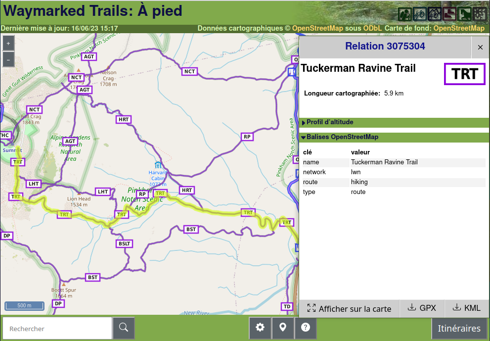
- [1] … the OSM-based Waymarked Trails map? It helps monitor super-route and route relations and offers fruitful documentation on hiking trails using OSM tags, including network, reference, level of difficulty (
sac_scale), trail symbols (osmc:symbol) and elevation profiles. The OSM hierarchy of routes and super-routes allows the presentation of elevation profiles and downloading trails at various level of detail in kml and gpx formats. See the other sports covered by Waymarked Trails on their website.
Other “geo” things
- Natalie Stechyson (CBC News) discussed declining map-reading skills in the age of GPS. Although some bemoan the apparent decline in people’s map-reading skills, George Bevan pointed out that in many ways, maps are more embedded in our day-to-day lives than they’ve ever been, noting how much we all use GPS, satellite views, and Google maps.
- Since 2007 negotiations ► have been going on between Germany and Switzerland to conclude a new treaty that will see the High Rhine border being redefined as the centreline rather than the currently used thalweg. In preparation, surveyors have been marking out the new border, which has resulted in the border moving 8 m closer to Switzerland on the Holzbrücke Bad Säckingen.
- gontsa tweeted Sentinel-2 spectral images of the flooded areas resulting from the destruction of the Kakhovka Hydroelectric Power Plant Dam.
 ►
►Upcoming Events
| Where | What | Online | When | Country |
|---|---|---|---|---|
| Bari | FOSS4G-it 2023 | 2023-06-12 – 2023-06-17 |  | |
| Eti Osa | Open Source for Good with Open Street Maps | 2023-06-15 – 2023-06-17 | ng | |
| Kaiserslautern | OSM Mapping Event Erfassung von Barrieren | 2023-06-17 |  | |
| Anglet | Cartopartie à Anglet (64) | 2023-06-17 |  | |
| City Of Cockburn | Social Mapping Saturday: Port Coogee | 2023-06-17 |  | |
| Waterford City Metropolitan District | Using OpenStreetMap to record place names | 2023-06-17 |  | |
| Toulouse | Réunion du groupe local de Toulouse | 2023-06-17 | | |
| MapRoulette Nights | 2023-06-18 | |||
| Reunião – OSM Brasil – Mapeamento Aberto para Gestão de Riscos/Desastres [Horário 2] | 2023-06-19 | |||
| 삼성2동 | 국경없는의사회 한국지부 Missing Maps 온라인 매파톤 | ✓ | 2023-06-20 |  |
| Gent | OpenStreetMap meetup in Gent | 2023-06-20 |  | |
| Lyon | Réunion du groupe local de Lyon | 2023-06-20 | | |
| 164. Treffen des OSM-Stammtisches Bonn | 2023-06-20 | |||
| San Jose | South Bay Map Night | ✓ | 2023-06-21 |  |
| City of Edinburgh | OSM Edinburgh Social | 2023-06-20 |  | |
| The Municipal District of Kilkenny City | Kilkenny History Mappers 1st MeetUp | 2023-06-20 | | |
| Lüneburg | Lüneburger Mappertreffen (online) | 2023-06-20 | | |
| Karlsruhe | Stammtisch Karlsruhe | 2023-06-21 | | |
| Mainz | OpenStreetMap-Stammtisch Mainz | 2023-06-21 | | |
| UN Mappers – OSM and humanitarian mapping training – session #8 | 2023-06-22 | |||
| Hlavní město Praha | Missing Maps MSF CZ Mapathon at Logio | 2023-06-22 |  | |
| Localidad Teusaquillo | Junta Bimensual OSM LATAM – Junio | June | 2023-06-24 | |
| MapRoulette Nights | 2023-06-25 | |||
| Prizren | FOSS4G | 2023-06-26 – 2023-07-02 |  | |
| Bremen | Bremer Mappertreffen (Online) | ✓ | 2023-06-26 | |
| OSMF Engineering Working Group meeting | 2023-06-28 | |||
| Aachen | 3. Treffen Aachener Stammtisch 2.0 | 2023-06-28 | | |
| UN Mappers – OSM and humanitarian mapping training – session #9 (final) | 2023-06-29 | |||
| 中正區 | TomTom x OpenStreeetMap Taiwan Mapping Meetup | 2023-06-30 |  | |
| Düsseldorf | Düsseldorfer OpenStreetMap-Treffen | 2023-06-30 | |
Note:
If you like to see your event here, please put it into the OSM calendar. Only data which is there, will appear in weeklyOSM.
This weeklyOSM was produced by MatthiasMatthias, PierZen, Strubbl, TheSwavu, barefootstache, derFred.
We welcome link suggestions for the next issue via this form and look forward to your contributions.