02/02/2021-08/02/2021
Vaccination map by the Ministry of Health of Peru 1 | © Ministerio de salud, Peru | map data © OpenStreetMap contributors
About us
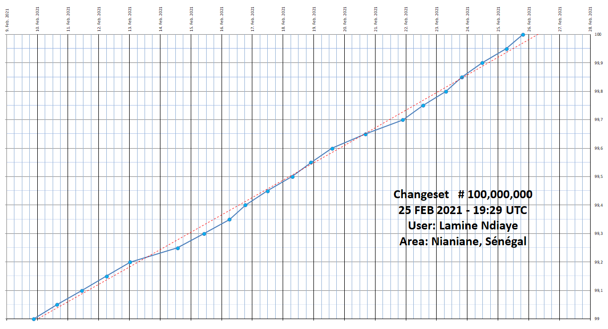
- In a few days (probably 27 February), the 100,000,000th changeset will be published in OpenStreetMap. This counter tool shows the changeset numbers in real time. In the next issue we will update our current projection. The editors of weeklyOSM would like to start a small challenge: the goal is for the mapper of the 100,000,000th CS to contact us (via any known channel). We are keen to conduct a small interview with this user, which will be published, or he or she will be mentioned in weeklyOSM. In addition, there is the possibility of a nice gift from Geofabrik to the lucky mapper: an individually designed large map of the winner’s surroundings, or anywhere else in the world. Good luck!
Mapping
- An old proposal has been revived for tagging couloirs, narrow very steep breaks in mountainous terrain. These are particularly of interest to skiers and mountaineers, who regard them as highly distinctive features, as shown by several comments on the tagging mailing list. (Nabble)
- A proposal has been made for the
landuse=shrubsvalue. This tag would be used on areas in built environments, filled with bushes wherebarrier=hedgecan’t be applied. A tag obviously made for the Knights who say ‘Ni’. - Reddit user Buster452 wrote about the importance of mapping dead-end roads on the OpenStreetMap subreddit. In his words, ‘It’s passing knowledge on to someone on the ground so they can make a navigation decision whether to take that road or not’.
- Florian Lainez (user overflorian) got over-enthusiastic and made a large mechanical edit without pre-announcing it. The replacement of the tag
diplomatic=consulate_generalwithconsulate=consulate_generalis broadly accepted but, as ever, the policies should be followed. Consequently the edit was reverted and Florian apologised. - The tag
healthcare=sample_collectionwas proposed for a ‘site or dedicated healthcare facility where samples of blood/urine/etc. are obtained or collected for the purpose of analysing them for healthcare diagnostics’. The proposal vote is open until Tuesday 16 February. - Flo Edelmann is asking for feedback on the proposed
takeaway:own_dishes=*tag, which specifies whether a takeaway restaurant accepts customers’ own dishes to help reduce packaging waste. - The proposal to modify the vote counting rules was accepted.
Community
- Seth Deegan (lectrician1) pointed out that they had opened two issue tickets for the main OpenStreetMap website. Both proposed changes relate to the header area. The first proposal is to add a link to the wiki whereas the second is to move the ‘export’ button to the right hand tool pane.
- Mateusz Konieczny proposes running an automated bot edit that will remove tracking parameters from URLs in OSM tags such as
website=. The URLs themselves will be preserved, and dubious cases will be flagged for manual review. - Frederik Ramm asked for self-moderation in the Tagging mailing list, to avoid things like ‘repetition of one’s own arguments’, ‘repetition of someone else’s arguments in different words’, ‘quick-fire responses’, ‘mistaking the list for a voting platform’, or ‘wanting to comment on everything’, among others. (Nabble)
- OpenCage tweeted a small thread of highlights from over five years of OpenStreetMap interviews with communities across the world.
- User SomeoneElse described in detail how to add a resource to the OpenStreetMap Community Index, a project that lists OSM-related resources (in-person and virtual meeting options, mailing lists, chats…) around the world. He details how to clone a GitHub repository.
OpenStreetMap Foundation
- Results of the OSMF 2021 Community Survey will be posted as results become available, starting with basic summary statistics, then additional details as the analysis continues. The raw data will be posted after they have been anonymised so that anyone interested may analyse them. As of 9 February, 4460 tokens had been requested, resulting in 3808 responses of which 2664 were in full. Based on demographic data from the in full responses, 8.08% are female, 89.45% are male, 1.37% are non-binary, and 1.1% are other.
- In his OSM diary, Nicolas Chavent suggests that the OSMF and local chapters formalise the current practice, still unwritten, of banning the provision of paid services as a source of funding, for the sake of their autonomy and internal governance.
- OpenCage and the OSMF announced that the former is now a silver level corporate member. The joint press release describes OpenCage’s geocoding service, which uses OSM data.
Local chapter news
- Rory McCann (OSMF Board) asked the OSM community of Japan, and OSMF members, about OpenStreetMap Foundation Japan’s application to become an official local chapter of the OSMF. Please forward your questions, comments or concerns by Tuesday 16 February 2021.
- OpenStreetMap Belgium’s Mapper of the Month for February is lhennen.
Humanitarian OSM
- Benjamin Herfort, from Heidelberg University, reported about global indicators of mapping related to the HOT Tasking Manager. Analysis in an associated blog post lets us see the progression in the number of contributors since 2012 followed by a decline since 2017. No breakdown of contributors by experience (i.e. days of contribution, objects edited, etc.) is given. The author notes that to associate all these tasks with humanitarian mapping (or all humanitarian mapping with only these tasks) is therefore an oversimplified definition and the results must be taken with a grain of salt.
- Bo Percival (user bo_hot) shared a call for volunteers for an experiment to test the efficiency and efficacy of AI assistance in the remote mapping of buildings. The experiment is organised by HOT, in partnership with NESTA Collective Intelligence grants, and the Netherlands Red Cross. The call for volunteers is open until Saturday 20 February.
- Resilience Mappers from Uganda have won a US$5000 microgrant to enable community engagement and participation in the HOT Summit 2021.
Education
- Rory McCann has shared a video tutorial on how to easily create one click tag presets in JOSM.
Maps
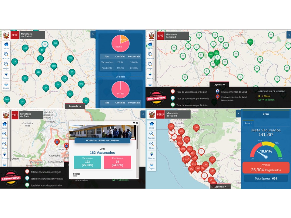
- [1] The Ministry of Health of Peru has created a ‘Vaccination Map’
 based on OpenStreetMap. The totals, first and second vaccination, and regional values are broken down for region, province, and district. The locations of vaccination centres are also shown on the map along with a lot of information that can be accessed through the map.
 based on OpenStreetMap. The totals, first and second vaccination, and regional values are broken down for region, province, and district. The locations of vaccination centres are also shown on the map along with a lot of information that can be accessed through the map.
Software
- The GIScience News Blog introduced a new tool based on ohsome. The preliminary results presented by the ohsome Quality AnalysT (OQT) website are about the completeness of mapping in a region (i.e. low level of buildings count vs population and the density of points of interest).
Programming
- OSM tools are often designed for Linux OS and the new WSL2 (Windows Subsystem for Linux) represents a good solution to use them from Windows, as Pierre Béland describes in his OSM diary. He recommends a virtual lightweight Ubuntu 20.04 OS environment to use Linux scripts in a development context on a Windows machine.
Did you know …
- … osm2pgsql, which converts OSM data for import into PostgreSQL databases?
OSM in the media
- The Russian and Ukrainian language media arms of the US-government-funded Radio Free Europe (Крим.Реалії > and Radio Svoboda > ) reported about the Ukrainian Railways objecting to the depiction of the borders of Crimea on OpenStreetMap.
- Local print > media and radio in San Juan (Argentina) covered Guillermo Maldonado’s work mapping the new public transportation system, now nearing completion. Although it is not long before its launch, clear maps of the routes have not yet been published. In order to understand the new network, Guillermo uploaded them to OpenStreetMap and created a uMap with the routes, which has been well received by locals.
- The Deccan Herald profiled Ramya Ragupathy, who works on analytics for the Humanitarian OpenStreetMap Team (HOT), in order to show what’s involved in the multi-disciplinary role of a ‘data scientist’.
- The Inverness Courier reported on volunteer mappers in the UK who are adding buildings on OpenStreetMap in Tanzania, as part of a Crowd2Map initiative to fight female genital mutilation.
 >
> 
 >
> Other “geo” things
- Google started to roll out a new version of Google Maps in January 2021, featuring pedestrian oriented details such as pedestrian crossings and pavements. To do so, Google is using an automated system, analysing satellite imagery and Street View.
- Pocketnavigation profiled >
changes that have been made to the Outdooractive web portal and smartphone app, which now show blocked and closed routes. - The Swiss Federal Office of Topography, swisstopo, has completed > a seven year process of revising official maps to use digital cartography.
 >
> 
Upcoming Events
| Where | What | Online | When | Country |
|---|---|---|---|---|
| OSMF Survey 2021 | 2021-01-25 – 2021-02-14 | |||
| Gülşehir merkez | 2021-02-10 – 2023-02-10 |  | ||
| Jóvenes Mapeadores Universidad de Panamá: Día de Carnaval Virtual 2021 Mapathon | 2021-02-13 | |||
| OSMPH Wiki pages edit-a-thon | 2021-02-13 | |||
| OpenStreetMap Ghana: Mapping Accra Mapathon | 2021-02-13 | |||
| Missing Maps CartONG Mapathon | 2021-02-15 | |||
| Missing Maps American Red Cross Poland Mapathon | 2021-02-15 | |||
| Youth Innovation Lab: Learning OpenStreetMap Training and Mapathon | 2021-02-16 | |||
| Lyon | Rencontre mensuelle (virtuelle) Lyon | ✓ | 2021-02-16 |  |
| Missing Maps London mid-month Mapathon | 2021-02-16 | |||
| Berlin | OSM-Verkehrswende #20 (Online) | 2021-02-16 |  | |
| 136. Treffen des OSM-Stammtisches Bonn | 2021-02-16 | |||
| Lüneburg | Lüneburger Mappertreffen (online) | ✓ | 2021-02-16 | |
| Albuquerque | MapABQ February virtual meetup | 2021-02-18 |  | |
| Stammtisch Köln | 2021-02-17 | |||
| Kadıköy | Yer Çizenler Aylık Mapathon | 2021-02-17 | | |
| San Jose | Virtual Civic Hack & Map Night | ✓ | 2021-02-19 | |
| gmina Krośniewice | Virtual community meeting. | 2021-02-19 |  | |
| YouthMappers + MapBeks: OSM Workshop and Mapathon | 2021-02-20 | |||
| Department of Geography Brown Bag/PGS Lecture: Participatory Mapping of LGBT Experiences and Safe Spaces | 2021-02-20 | |||
| OpenStreetMap Hungary Workshop: Buszútvonalak hozzáadása szakszerűen / Adding bus routes | 2021-02-22 | |||
| Missing Maps CartONG Mapathon | 2021-02-22 | |||
| Bremen | Bremer Mappertreffen (Online) | 2021-02-22 | | |
| Ville de Bruxelles – Stad Brussel | Virtual OpenStreetMap Belgium meeting | ✓ | 2021-02-23 |  |
| Disastermappers Heidelberg: Access to Healthcare Infrastructure Mapathon | 2021-02-23 | |||
| Missing Maps Friends of MSF Newcastle Mapathon | 2021-02-24 | |||
| Missing Maps Spanish Red Cross Mapathon | 2021-02-24 | |||
| Vandœuvre-lès-Nancy | Rencontre mensuelle (virtuelle) Nancy | 2021-02-24 | | |
| Missing Maps German Red Cross: Validierungsmapathon für erfahrene Kartierer | 2021-02-24 | |||
| Osborne County | OpenStreetMap U.S. Virtual Mappy Hour | ✓ | 2021-02-25 | |
| 2021-02-25 | ||||
| okres Žilina | Missing Maps mapathon Slovakia online #2 | ✓ | 2021-02-25 |  |
| Missing Maps German Red Cross Mapathon | 2021-02-25 | |||
| Humanitarian OpenStreetMap Team Community WG: Colonialism in Open Data and Mapping Webinar | 2021-02-26 | |||
| Humanitarian OpenStreetMap Team Community WG: Colonialism in Open Data and Mapping Webinar | 2021-02-26 | |||
| gmina Krośniewice | Virtual community meeting. | 2021-02-26 | | |
| Virtueel treffen Openstreetmap NL | 2021-02-27 | |||
| Essen | FOSSGIS-OSM-Communitytreffen (Online) | ✓ | 2021-02-28 | |
| Missing Maps CartONG Mapathon | 2021-03-01 | |||
| London | Missing Maps London Mapathon | ✓ | 2021-03-02 | gb |
| Landau an der Isar | Virtuelles Niederbayern-Treffen | ✓ | 2021-03-02 | |
| San Jose | Virtual Civic Hack & Map Night | ✓ | 2021-03-05 | |
| Nordrhein-Westfalen | Mapper*innentreffen Bochum | 2021-03-04 | | |
| gmina Krośniewice | Virtual community meeting. | 2021-03-05 | | |
| Open Data Day 2021 | 2021-03-06 | |||
| Dar es Salaam | Tanzania Data Lab + OpenMap Development Tanzania: HIV/AIDS hotspots and testing facilities Mapathon | 2021-03-06 |  | |
| 臺北市 | Open Data Day Taiwan 2021 | 2021-03-06 |  |
Note:
If you like to see your event here, please put it into the OSM calendar. Only data which is there, will appear in weeklyOSM.
This weeklyOSM was produced by Anne Ghisla, Lejun, MatthiasMatthias, Nordpfeil, PierZen, Polyglot, rogehm, SK53, Sammyhawkrad, TheSwavu, YoViajo, derFred, edvac.