16/02/2021-22/02/2021
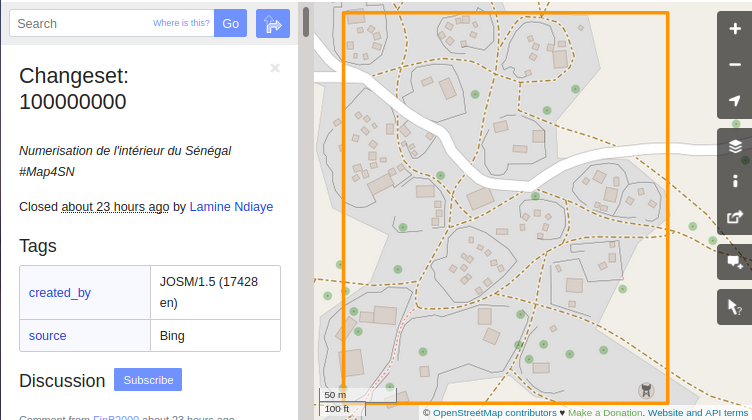
OSM Changeset #100.000.000 by Lamine Ndiaye [1] | map data © OpenStreetMap contributors
Breaking news
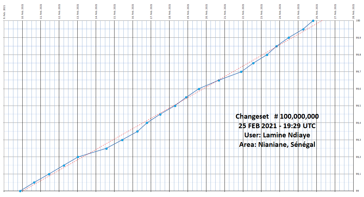
- Congratulations to Lamine Ndiaye for uploading OSM changeset #100,000,000! He has been mapping since 2013 and was nominated (
 and ) for the OSM Awards in 2017. Take a look at how our prediction of when the event would occur turned out. If you missed seeing the big event on James Westman’s OSM In Realtime you can watch TheSwavu’s replay.
 and
and  ) for the OSM Awards in 2017.
 Mapping campaigns
- UN Mappers has opened a new mapping project in the Central African Republic (CAR) to edit topographic features. The project welcomes any contribution that helps bring peace to this country, especially in the Bangassou area.
Mapping
- In the course of a mapping action for protected and sanctuary areas > in Germany and Austria, a reference map > for the currently mapped protected and sanctuary areas was created. All protected areas are available as WMS layers as well as GeoJSON and KML exports. More details on XCTrails ReleaseNotes > and technical background > (post #198).
- User quilkin asked, on the forum, about the longest single way on OSM tagged as a highway. Needless to say this provoked some others to investigate. So far it appears that the longest highway mapped as a single way is 462 km of the Birdsville Track in Australia.
- Mateusz Konieczny provided his error reports derived from an evaluation of the quality of Wikidata tags in OSM.
- Requests have been made for comments on the following proposals:
place_of_worship=holy_wellfor a place where Catholics celebrate the well’s patron saint with a mass once a year (‘pattern’), collect ‘holy water’, and sometimes leave votive offerings in the well (coins) or at a nearby wish tree.natural=shrubberyto tag an area of cultivated decorative shrubs or bushes.- Coin and note acceptance to specify which coins or notes are accepted by an ATM or vending machine.
- Voting is underway for the following proposals:
natural=couloirfor a seam, scar, fissure, or vertical crevasse in an otherwise solid mountain mass (till Thursday 4 March).- Change vote counting rules to remove the references to ‘rule of thumb’ and ‘other factors may also be considered’ (till Thursday 4 March).
- Voting has ended for the following proposals:
wait=*wasn’t successful with 7 votes for, 9 votes against, and no abstentions.
 >
> 
Community
- Paul Norman started plotting the first results of OSMF Community Survey, and made some initial observations about outliers and distribution of data.
- OSMF board member Rory McCann summarised their own OSM activities in January.
- Kai Schröter and colleagues examined whether OpenStreetMap data on buildings are useful for flood vulnerability modelling.
- Rabin Ojha presented an overview of OSM activity in Nepal last year, 2020: from a noticeable increase in map contributions, to long-term projects led by organisations including Kathmandu Living Labs, NAXA, Youth Innovation Lab, YouthMappers and the World Food Programme, among others.
OpenStreetMap Foundation
- PierZen published a list of individual comments related to the diversity and inclusion committee, and the Code of Conduct, from the recent 2021 OSMF Community Survey. An interesting read.
- OSMF Board member Guillaume Rischard (user Stereo) processed the responses regarding Board priorities for 2021 from the OSMF Community Survey.
Local chapter news
- Videos and slides are now available , on YouTube, from the FOSSGIS-Update online conference > held in January.
- OpenStreetMap US thanked Craigslist Charitable Fund for its generous donation and its five-year history of supporting OpenStreetMap US.
Events
- Marco Minghini is calling for applications for the Scientific Committee Academic Track at the State of the Map 2021. The deadline is Friday 5 March.
- GISRUK (GIS Research UK) Chair Peter Mooney invites you to an online seminar about ‘Semantic geographic knowledge on a world-scale—interlinking OpenStreetMap and knowledge graphs’, to be given by Prof. Dr. Elena Demidova. The lecture will introduce emerging approaches that address tighter integration of OSM and knowledge graphs; it will give particular attention to link discovery and semantic enrichment of OSM datasets. The event is planned for Thursday 25 March at 14:00–15:00 UTC and requires registration.
Humanitarian OSM
- HOT is partnering with OpenMap Development Tanzania (OMDTZ) to pilot the development of investment in mapping communities in Tanzania. The idea is that using a trusted partner at a national level enables better understanding of the nuances of local community needs.
- Rubén Martín (nukeador), HOT Community Strategist and Research Lead, continued his series of blog posts with one on understanding the humanitarian open mapping community. Next month’s will focus on discussions with the newly created Regional Hubs and membership to establish plans of action to support OSM local communities.
Maps
- James Ross (twpol) has created a tile renderer, which renders a road overlay, with lanes, according to various selected tags.
- Romania’s national programming platform for vaccination against COVID-19 makes use of (Romanian) > an OSM-based map to display the locations of vaccination centres.
Open Data
- How the Indian Government has changed its guidelines on geospatial data and services has been widely reported, including in the Hindu Times and TechCrunch. This new development evoked positive responses from long-time Indian OpenStreetMappers Arun Ganesh (planemad) and Sajjad Anwar (geohacker). Together with Pranesh Prakash, Sajjad provided a more detailed perspective in an article for CNN News18.
Releases
- QGIS 3.18, with new highlights and features such as native point cloud support, is now available.
OSM in the media
- Bloomberg CityLab used a rather sensationalist title, ‘Inside the “Wikipedia of Maps”, Tensions Grow Over Corporate Influence’, to report on corporate involvement in mapping in OpenStreetMap.
- Jonah Adkins , of Stamen, details their design and cartographic decisions behind the newly launched Facebook Global Map project, which is based on OSM data.
Other “geo” things
- A group of researchers have developed new techniques for simulating the deep history of the Earth’s surface. You can watch an animation of the last billion years in Alan Collin’s tweet. In a journal paper Andrew S. Merdith and colleagues describe their method, which allows for the movement of complete tectonic plates, rather than continental landmasses, to be reconstructed for the past billion years. The advantage of modelling the entire plate rather than just continental drift is that the properties of plate boundaries can be properly taken into account.
- Want to view Apple Maps, but you only have a Windows or Android device? All is explained by How to Geek.
- The Economic Times reported on a new partnership between the ISRO (the Indian space agency) and digital map provider MapmyIndia to provide new made-in-India geospatial solutions.
- Places in Japan with loud gossiping adults and boisterously noisy children are on the Dorozoku map, a country otherwise known for its quiet.
- Here is a new attempt to create the ‘Most Accurate Flat World Map’, with a division of the projection into front and back sides of the earth.
- Natural Earth released additional ‘point-of-view’ versions of the country theme to accommodate places like China and India, which mandate by law the use of particular boundaries that don’t always reflect reality, in published maps.
- The latest news from ArcGIS: a new OpenStreetMap Daylight map (beta) is being further developed with regular updates and releases.
Upcoming Events
| Where | What | Online | When | Country |
|---|---|---|---|---|
| Virtueel treffen Openstreetmap NL | 2021-02-27 | |||
| Univers3s: Séminaire de Formation en OpenStreetMap | 2021-02-27 – 2021-02-28 | |||
| Biella | Incontro mensile OSMers BI-VC-CVL (online) | 2021-02-27 – 2021-02-28 |  | |
| Friends of MSF Ottawa Mapathon on/sur OpenStreetMap | 2021-02-27 – 2021-02-28 | |||
| Colectivo das Pedras Galladas: Obradoiro de OpenStreetMap | 2021-02-27 | |||
| Essen | FOSSGIS-OSM-Communitytreffen (Online) | ✓ | 2021-02-28 |  |
| Missing Maps CartONG Mapathon | 2021-03-01 | |||
| London | Missing Maps London Mapathon | ✓ | 2021-03-02 | gb |
| Landau an der Isar | Virtuelles Niederbayern-Treffen | ✓ | 2021-03-02 | |
| UN Mappers weekly mapathon | 2021-03-03 | |||
| Missing Maps German Red Cross: Validierungsmapathon für erfahrene Kartierer | 2021-03-03 | |||
| TechGirlz Workshop: Mapping For Humanity, Using Digital Mapping To Better The World | 2021-03-04 – 2021-03-05 | |||
| San Jose | Virtual Civic Hack & Map Night | ✓ | 2021-03-05 |  |
| Dresden | Dresdner OSM-Stammtisch | ✓ | 2021-03-04 | |
| OSGeo.nl: De Grote Geo Show OpenStreetMap Special | 2021-03-04 | |||
| Nordrhein-Westfalen | Mapper*innentreffen Bochum | 2021-03-04 | | |
| Ville de Bruxelles – Stad Brussel | Open Belgium 2021 : OSM news and discussions | ✓ | 2021-03-05 |  |
| Missing Maps UC Davis Doctors Without Borders Mapathon | 2021-03-05 | |||
| gmina Krośniewice | Virtual community meeting. | 2021-03-05 |  | |
| Open Data Day 2021 | 2021-03-06 | |||
| Dar es Salaam | Tanzania Data Lab + OpenMap Development Tanzania: HIV/AIDS hotspots and testing facilities Mapathon | 2021-03-06 |  | |
| Kampala | OpenStreetMap Uganda Mapping Uganda’s New Cities Mapthon | 2021-03-06 |  | |
| 臺北市 | Open Data Day Taiwan 2021 | 2021-03-06 |  | |
| Quezon City | MAPAbabae 2021: #ChooseToChallenge Gender Inequality in Open Mapping | ✓ | 2021-03-06 |  |
| Open Gender Data for Tanzania – What is missing? Why does it matter? | 2021-03-06 | |||
| Missing Maps American Red Cross International Women’s Day Mapathon 2021 | 2021-03-08 | |||
| Missing Maps CartONG Mapathon | 2021-03-08 | |||
| 臺北市 | OSM x Wikidata #26 | 2021-03-08 | | |
| Osborne County | OpenStreetMap U.S. Virtual Mappy Hour | ✓ | 2021-03-09 | |
| Hamburg | Hamburger Mappertreffen | 2021-03-09 | | |
| Briefing on OSMF 2021 Community Survey | 2021-03-10 | |||
| Torino Virtual Mapping Party 2021 | 2021-03-10 | |||
| Chippewa Township | OpenStreetMap Michigan Meetup | ✓ | 2021-03-11 | |
| Missing Maps German Red Cross Einführung JOSM Mapathon | 2021-03-10 | |||
| Briefing on the 2021 OSMF Community Survey | 2021-03-10 | |||
| Briefing on the 2021 OSMF Community Survey | 2021-03-11 | |||
| NIGERIA SE4ALL Remote Mapathon | 2021-03-11 | |||
| UN Mappers weekly mapathon | 2021-03-11 | |||
| Zürich | OSM-Treffen Zürich | 2021-03-11 |  | |
| München | Münchner OSM-Stammtisch | 2021-03-11 | | |
| Berlin | 153. Berlin-Brandenburg OpenStreetMap Stammtisch (Online) | 2021-03-11 | | |
| Berlin | Remote DB Regio Hackathon | 2021-03-12 – 2021-03-13 | | |
| Missing Maps Friends of MSF Lancaster Mapathon | 2021-03-13 | |||
| Missing Maps CartONG Mapathon | 2021-03-15 | |||
| 137. Treffen des OSM-Stammtisches Bonn | 2021-03-16 | |||
| Berlin | OSM-Verkehrswende #21 (Online) | 2021-03-16 | | |
| Lüneburg | Lüneburger Mappertreffen (online) | 2021-03-16 | | |
| San Jose | Virtual Civic Hack & Map Night | ✓ | 2021-03-19 | |
| UN Mappers weekly mapathon | 2021-03-19 |
Note:
If you like to see your event here, please put it into the OSM calendar. Only data which is there, will appear in weeklyOSM.
This weeklyOSM was produced by Anne Ghisla, Lejun, Nordpfeil, PierZen, rogehm, SK53, Guillaume Rischard (Stereo), TheSwavu, YoViajo.
Das Hauptfeature der Apple maps app, realistische 3D-Karten mit mehreren Detailstufen und Texturen, ist über DuckDuck allerdings nicht verfügbar.