29/11/2022-05/12/2022
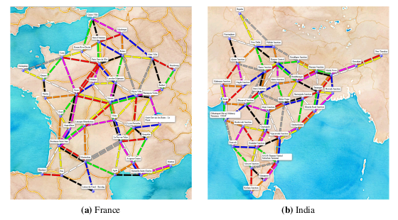
Creating boards for board games using OSM data [1] | © Wenzel Friedsam © Map tiles by Stamen Design, under CC BY 3.0 | map data © OpenStreetMap contributors
Mapping
- Anne-Karoline Distel recounted her experiences of mapping defibrillator locations in County Kilkenny, Ireland.
- Tiago Lubiana shared a Wikidata query that shows a map of the COVID-19 memorials
 ► in Brazil.
 - Requests have been made for comments on the following proposals:
snow_chainsto map where and when you need to use snow chains on your vehicle.is_sidepath=*for indicating whether or not a way is associated with a road.
- Voting on the following proposals has closed :
- Standardising the tagging of
manufacturer:*=*andmodel:*=*of artificial elements was approved with 25 votes for, 0 votes against and 2 abstentions. archaeological_site=*, to replace thesite_type=*key for tagging the type of archaeological site, was approved with 20 votes for, 4 votes against and 0 abstentions.
- Standardising the tagging of
 ►
►
Community
- A discussion on talk-ca showed that the naming of territories is not always neutral. It is often related to the colonial past of both the USA and Canada when they moved nomadic indigenous nations from their ancestral territories to villages called ‘Reserves’. There are different perceptions among contributors from these two countries on how to name these territories, but most feel that there is no generally applicable rule, so the mapper should use their judgement on a case-by-case basis.
- Nighto pointed out that the road category
highway=busway, which was accepted one and a half years ago, is still not rendered in OSM Carto, the default map style on the OSM website. As a result, bus rapid transit routes that are common in some countries have not been updated to the new tagging in many cities, or where this has already been done, it results in an unattractive map representation. - The OSM Niger Community announced ► their registration as a non-profit organisation. According to the same announcement, the recognition procedure lasted four years before receiving the authorisation to operate.
- Søren Johannessen showed ► that the monthly edit rate of OpenStreetMap reached its global peak during the COVID-19 pandemic.
- janabau shared ten tips on how to build a mapping community.
- OpenStreetMap Belgium announced their December 2022 Mapper of the Month: Le Sharkoïste.
- Frans Schutz, from the Netherlands, is the UN Mapper of the Month for December.
 ►
► ►
►Events
- The 30DayMapChallenge 2022 on Twitter and Mastodon has finished. It is not possible to adequately acknowledge the multitude of outstanding works. The selection we make is purely random and not an evaluation. Please take a look at the works yourself.
- Day 29: Out of my comfort zone | Kirsty Wilcox @kirstywilcox2 * DSM (Digital Surface Model) of Southern Peru using Relief Visualisation toolbox in QGIS | Antonia Blankenberg 🗺️ @MapsByAntonia * relative elevation model | Andrew Tyrrell @SouthArrowMaps * Craigieburn Range |
- Day 30: Remix | BC (aka @mildthing99) @BC@mastodonapp.uk * 30DayMapChallenge | LatidudeMaps @LatidudeMaps * 30DayMapChallenge | Xemartin Laborde
@XemartinLaborde * 30DayMapChallenge |
- HOT’s regional director for East and Southern Africa discussed the Humanitarian OpenStreetMap Team’s recent evolution and provided the highlights and the lowdown on what HOT is trying to achieve, and how, in the latest Geomob podcast.
- The next Geomob London will be at 6:30 PM on Wednesday, 18 January 2023 in Lecture Theatre G22, North-west Wing, University College London.
Education
- Following on from his MapRoulette tutorial, Martijn van Exel continued with an explanation of MapRoulette’s cooperative challenges. They involve collaboration between a challenge owner, providing the proposed OSM changes, and you, validating, tweaking and committing them to OSM. Cooperative challenges are ideal for when you may be thinking about an import, but you would like to have each feature manually verified by a mapper.
- The Polish OpenStreetMap Society has asked Anne-Karoline Distel, star of the ‘OSM for History Buffs’ channel on YouTube, to create a how-to video on adding AEDs to the OpenAEDMap website.
OSM research
- [1] Wenzel Friedsam has submitted a bachelor thesis to the University of Stuttgart, which is about creating boards for board games using OSM data.
Maps
- ArnaudChampollion has created a map of the regions and departments of France using uMap.
- Andreas Heil collects security incidents at German universities and has created a map of them. Missing entries can be reported to Andreas.
 a map of them. Missing entries can be
 switch2OSM
- The Hiking Club website is now recommending the Organic Maps (OSM-based) application to their customers for use when they are out on trails.
Software
- Mepo is a fast, simple, hackable OSM map viewer for mobile and desktop Linux. It downloads and renders maps and provides lots of extra functionality via its command language.
- Nat Zimmermann announced the release of osm-address-collector, a web application to easily survey addresses for OSM with no need to download data. It is inspired by the former Keypad Mapper.
Programming
- Dr Sybren A. Stüvel has published a tutorial on how to remove duplicate GPS waypoints in OsmAnd by using a Python script.
- rtnf explained how he used Python and the ohsome dashboard interface to dive into the OSM mapping history in his area.
- SK53 used MapCSS styling, within overpass turbo, to create a beautiful map with buildings colour-coded by age (The Overpass recipe is here). The colour scheme is based on an earlier map of Dutch buildings’ ages.
Releases
- The second November update of Organic Maps has been released.
Did you know …
- … this short tutorial on creating ► an interactive map with uMap?
- … that you can deactivate ► the lasso in JOSM?
Other “geo” things
- Julian Hoffmann shared a recap video that summarises all of his #30DayMapChallenge activities.
- Ed Freyfogle and Steven Feldman have released Geomob Podcast, episode 155. The podcast includes a recap of Geomob Tel Aviv followed by a discussion on whether and how the Opengeo scene is moving from Twitter to Mastodon.
- Rutger Roffel complained about the change in data protection at our market companions online map service. Google Maps has changed its URL from ‘https://maps [dot] google [dot] com’ to ‘https://google [dot] com/maps’. This may not look like it’s a big deal, but when you grant the location permission in your browser for Google Maps you are now granting it to the whole google [dot] com domain.
Upcoming Events
| Where | What | Online | When | Country |
|---|---|---|---|---|
| Localidad Barrios Unidos | Redacción de guía para abrir y cerrar notas para LearnOSM | 2022-12-10 |  | |
| [Online] 16th Annual General Meeting of the OpenStreetMap Foundation | 2022-12-10 | |||
| København | OSMmapperCPH | |||
| 歸仁區 | OpenStreetMap 街景踏查團 #5 | 2022-12-11 |  | |
| København | OSMmapperCPH | 2022-12-11 |  | |
| Grenoble | Rencontre du groupe local | 2022-12-12 |  | |
| West Northamptonshire | 2022-12-13 |  | ||
| [online] Geospatial Tech & Innovation Space | 2022-12-13 | |||
| HOT Open Tech and Innovation Session – Option 1 | 2022-12-13 | |||
| HOT Open Tech and Innovation Session – Option 2 | 2022-12-13 | |||
| [online] Geospatial Tech & Innovation Space | 2022-12-13 | |||
| City of Nottingham | OSM East Midlands/Nottingham meetup (online) | ✓ | 2022-12-13 | |
| Salt Lake City | OSM Utah Monthly Meetup | 2022-12-15 |  | |
| Rio de Janeiro | Workshop Mapeamento Participativo e Cartografia Social 2022 / Participatory Mapping and Social Cartography Workshop 2022 | 2022-12-14 – 2022-12-15 |  | |
| Michigan Meetup | 2022-12-15 | |||
| Stainach-Pürgg | 7. Virtueller OpenStreetMap Stammtisch Österreich | 2022-12-14 |  | |
| IJmuiden | OSM Nederland bijeenkomst (online) | ✓ | 2022-12-14 |  |
| Roma | Incontro dei mappatori romani e laziali | 2022-12-14 |  | |
| Brugge | OpenStreetMap meetup in Bruges | 2022-12-15 |  | |
| Toulouse | Réunion du groupe local de Toulouse | 2022-12-17 | | |
| London | London xmas pub meet-up | 2022-12-19 | | |
| OSMF Engineering Working Group meeting | 2022-12-19 | |||
| Bruxelles – Brussel | OpenStreetMap meetup in Brussels | 2022-12-20 | | |
| 158. Treffen des OSM-Stammtisches Bonn | 2022-12-20 | |||
| Lüneburg | Lüneburger Mappertreffen (online) | 2022-12-20 |  | |
| Karlsruhe | Stammtisch Karlsruhe | 2022-12-21 | | |
| Düsseldorf | Düsseldorfer OpenStreetMap-Treffen | ✓ | 2022-12-30 | |
Note:
If you like to see your event here, please put it into the OSM calendar. Only data which is there, will appear in weeklyOSM.
This weeklyOSM was produced by Elizabete, MatthiasMatthias, PierZen, SK53, SeverinGeo, Strubbl, TheSwavu, YoViajo, derFred, rtnf, 快乐的老鼠宝宝.
We welcome link suggestions for the next issue via this form and look forward to your contributions.
Der Link zum Proposal is_sidepath zeigt auf das Proposal snow_chains. Der korrekte Link wäre: https://wiki.openstreetmap.org/wiki/Proposed_features/Key:is_sidepath
Heureux d’être parmi vous la communauté OSMNiger, avec vous le développement social et économique sera au rendez vous, en diffusant des informations relatives aux SIG dans tous les domaines concernés et surtout le domaine de la recherche pour une meilleure prise de décision
“It is often related to the colonial past of both the USA and Canada when they moved nomadic indigenous nations from their ancestral territories to villages called ‘Reserves’.”
This is a dated stereotype. Many of the indigenous peoples who were forced onto reservations were not nomadic at all; they had extensive settlements for centuries before European contact. The land they were forced onto was completely undeveloped, not villages.
A more accurate explanation is that Canada and the United States have historically removed indigenous peoples from their traditional homelands and designated much smaller territories for them, called “reserves” or “reservations”, within which they now have limited sovereignty. For some nations, preserving and promoting their language and their name for their land is a way to exercise that sovereignty.