25/07/2023-31/07/2023
–
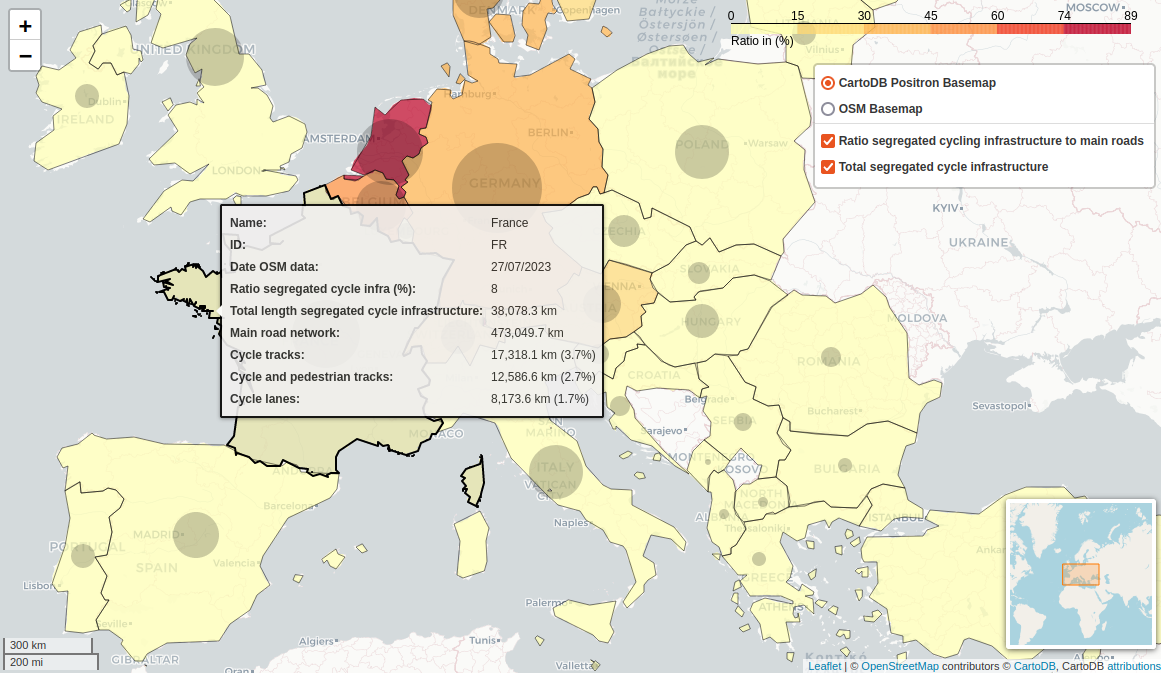
Ratio of segregated cycling infrastructure to the main road network [1] © ECF, OpenStreetMap contributors
Mapping
- Anne-Karoline Distel has added
name:etymology:wikidatatags to holy wells in Ireland and analysed the occurrences of different saints in their names. - HDYC is now equipped with a feature to identify which of your OpenStreetMap edits were undone by others. Check your HDYC profile, then click on the number of ‘reverted changes’.
- une abeille explained why they map pavements (sidewalks) as separate ways and provided step-by-step details on how to map pavements in iD.
- Requests have been made for comments on the following proposals:
noname=*to extend the existingnoname=yestag by adding additional values to indicate the reason why anametag is not presenthistoric=defensive_worksto make thedefensive_workskey a sub-tag, allowing mappers to use a generic tag for defensive works, which can later be specified withdefensive_works=*by mappers with more local knowledge and/or understanding of the topic.
Community
- Hungerburg realised that not many rock glaciers are mapped in his region of the Eastern Alps and discovered that there is an open dataset, which he analysed for importing to OSM.
- OpenStreetMap’s 19th anniversary will be celebrated on 9 August. OSM communities who would like to celebrate the occasion by organising local activities can sign up on the OpenStreetMap 19th Anniversary Birthday party wiki page.
Local chapter news
- OpenStreetMap US announced that Locana has joined the organisation as a Supporter member.
- Videos from the 2023 State of the Map US have been uploaded to YouTube.
Events
- The deadline for the call for abstracts for OSMScience 2023 (which takes place as part of State of the Map Europe 2023) has been extended to Thursday 24 August.
- Geomob tooted that they have no events planned for August but lots on the agenda from September onward.
- The State of the Map Europe team has opened their call for participation. Now is the time to submit your ideas for a presentation, workshop, or panel. The deadline is Thursday 24 August.
Education
- Rainbolt published a video on geolocating that makes use of overpass turbo.
OSM research
- [1] The European Cyclists’ Federation presented an analysis of the amount of segregated cycling infrastructure provided in 20 different European countries, expressed as a proportion of the length of each country’s main road network.
Maps
- Andy Townsend has created a Garmin map style and explained the details in his blog. The tags used are documented in taginfo.
Open Data
- The Overture Maps Foundation has released the Overture 2023-07-26-alpha.0 dataset. This dataset contains several layers, namely places of interest, buildings, transport networks, and administrative regions gathered from OSM and other sources.
- Umbra has released over USD 1 million of free SAR data since 15 March 2023.
Software
- Have a look at the pre-project demo version of a quality assessment tool (
&
menu) for OSM data, developed by the Heidelberg Institute for Geoinformation Technology.
- Rohit Gautam has released OSM-GPT, a chatbot to interact directly with OpenStreetMap data.
- OsmAnd 4.5 has been released for Android. It comes with a free backup function, new terrain and 3D relief formats, and the capability to connect Bluetooth sensors.
- StreetComplete is looking for translators (see the release notes for v53.3). Native speakers of Turkish, Malayalam, Amharic, Armenian, Bosnian, Norwegian Nyorsk, Galician, or Japanese can help translate the app on poeditor.com. Languages whose translation becomes low quality, due to lack of maintenance, are removed from the app until the translation quality is restored.
- Raster tile provider Tracestrack has open sourced Tracesmap, their generic online map, on GitHub. The map integrates many OpenStreetMap based services such as Tracestrack raster tiles, OpenRouteService, Overpass API, Nominatim search and OpenRailwayMap, as well as some commercial products like Mapbox satellite imagery, and TomTom Traffic.
Programming
- Are you interested in automating the extraction of information from the OpenStreetMap wiki by making it more machine-readable? This is what fititnt discussed in his diary entry.
- Brandon Liu has developed the Overture Places application, a web-based map for displaying the point-of-interest data that was recently released by the Overture Maps Foundation.
OSM in the media
- Kiran Herbert, of People for Bikes, reported that the city of Minneapolis has the highest cycling comfort index score in the United States. This score is measured based on bike lane data available on OpenStreetMap.
Other “geo” things
- Manon Bischoff wrote
►
an article in Spektrum der Wissenschaft about the history of the search for proof of the four colour conjecture (the idea that you can colour any map using no more than four different colours).
Upcoming Events
Note:
If you like to see your event here, please put it into the OSM calendar. Only data which is there, will appear in weeklyOSM.
This weeklyOSM was produced by MatthiasMatthias, Nordpfeil, PierZen, TheSwavu, barefootstache, conradoos, derFred, rtnf.
We welcome link suggestions for the next issue via this form and look forward to your contributions.