25/04/2023-01/05/2023
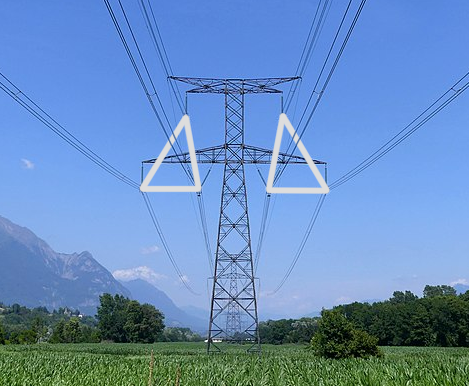
Illustrate the arrangement of high voltage lines [1] | © CC-BY-SA-4.0 François Lacombe Florian Pépellin
Mapping
- [1] The proposal about arrangement of power lines is now requesting comments (RFC). It aims to describe how line bundles are arranged around their supports or way points. They can be arranged horizontally, vertically or even as a delta shape.
- The
parking_space=collectionproposal is in RFC. The tag will describe parking spaces designated for customer collection or pick-up. - The
kerb:approach_aid=yes/noproposal is open for voting until Monday 15 May. - Peter Elderson blogged about how to map a turbo roundabout using JOSM. A turbo roundabout allows drivers to select their direction before entering, which is then enforced through the roundabout.
- SK53 investigated if
leisure=pitchwithsport=tennisis being used only for single tennis courts. He ran a query which pulled tags, the geometry and the area of each pitch, in square metres, to check – the answer was no. Only about a quarter of tennis ‘pitches’ represent a single court, with at least as many objects representing two courts and a similar number more than two courts. A tiny proportion has tags indicating how many courts are represented by each area. - The Duitama Mapping Stars from Salesian College in Duitama, Columbia, aged 13 to 16, have mapped sustainable transportation in their home town and beyond, in cities such as Bogota, Zitácuaro, Oururo, and Nairobi.
Mapping campaigns
- AE35 reported
 ► that the Danish MapRoulette Cemetery Challenge started on Monday 26 March. The task is to map all footpaths and steps in 2440 Danish cemeteries. On 2 May, 50% of the task had already been completed. Nineteen volunteers have so far added about 17,000 new footpaths/steps and 511 flagpoles. The goal is to complete the project before Christmas.
 ►
►
Community
- Andres Gomez Casanova wrote ► another entry in his diary on websites that are easy to use from mobile devices to improve OSM data, extending his first overview of mobile apps (we reported earlier).
- ivanbranco blogged an amazing list of his favourite OSM-related tools/websites/apps with brief descriptions of each. Matt Whilden added three more interesting tools in his comment.
 ►
►Events
- Maria Pilar Pearl Mateo has published ► a long article in the Heraldo about mapathons organised by the University of Zaragoza and the Collaborative Mapping / Geoinquietos Zaragoza group. She covered mapathons in Malawi, Nigeria, and Tanzania and explained why these activities are necessary.
- The programme for the State of the Map US 2023 is now available online.
OSM research
- Filip Biljecki et al. published research on the quality of building attributes in OpenStreetMap.
- Courtney Williamson has invited the readers of weeklyOSM to take a survey (via LimeSurvey or Google Survey) about how the OSM community uses forums, mailing lists, social media and other channels to communicate. The results of the survey will be presented at the State of the Map US on Friday 9 June. The survey is being conducted in a private capacity and is not a project of the OSMF Communication Working Group.
Software
- Dustin Carlino has published a tool called Route Snapper, which allows you to mark an area by marking the surrounding roads.
- User YPGGUUY has written ( and ) a simple Python script to check the quality of a bus network; the code is hosted on GitFront.
 and
and  ) a simple Python script to check the quality of a bus network; the code is hosted on
 Programming
- Lejun showed ► how to create an R script to analyse the distributions of polygon areas in OpenStreetMap. The work was prompted by SK53’s diary entry described above.
 ►
►Releases
- Version 0.7.60 of the Overpass API is out and a blog post presents the enhancements. This version addresses primarily those people that maintain an instance of the database on magnetic hard drives. The data format on the backend has been changed so that updates now run four times faster.
Did you know …
- … the wiki page Good practice? It is guide for mappers on ways to be more helpful.
- … there is a FOSS fork of signal messenger for Android, that uses OpenStreetMap for maps?
Other “geo” things
- Giorgio Comai published an article on Medium, describing the process to create Mapping Diversity. It combines data from OpenStreetMap, Wikidata, and open government data to map and show statistics about the gender of people who have a street named after them.
Upcoming Events
| Where | What | Online | When | Country |
|---|---|---|---|---|
| San Jose | ✓ | 2023-04-30 – 2023-06-30 |  | |
| SotM Asia 2023 Meeting Kickoff | 2023-05-06 | |||
| Localidad La Candelaria | Ponencia: OpenStreetMap, datos de vida | 2023-05-06 |  | |
| Localidad La Candelaria | Taller: Introducción a OpenStreetMap como parte del Flisol | 2023-05-06 – 2023-05-07 | | |
| London | OSMLondon pub meet-up | 2023-05-09 |  | |
| San Jose | South Bay Map Night | ✓ | 2023-05-10 | |
| Formação UN Mappers: OpenStreetMap e o mapeamento humanitário – sessão 8 | 2023-05-10 | |||
| Mitgestaltung der OpenStreetMap Konferenz zur FOSSGIS | 2023-05-10 | |||
| Hannover | OSM-Stammtisch Hannover | 2023-05-10 |  | |
| München | Münchner OSM-Treffen | 2023-05-10 | | |
| Salt Lake City | OSM Utah Monthly Map Night | 2023-05-11 | | |
| “Open- und OpenStreetMap-Daten in Blaulichtorganisationen” (Schweiz) | 2023-05-11 | |||
| Zürich | OSM-Stammtisch | 2023-05-11 |  | |
| Berlin | 179. Berlin-Brandenburg OpenStreetMap Stammtisch | 2023-05-11 | | |
| Zaragoza | esLibre 2023 | 2023-05-12 – 2023-05-13 |  | |
| Briançon | Parlons d’OpenStreetMap | 2023-05-12 |  | |
| Verona | MERGE-it | 2023-05-12 – 2023-05-13 |  | |
| Gap | Parlons d’OpenStreetMap | 2023-05-12 | | |
| Sülysáp | Mapping around Sülysáp before, after and during breaks of qbParty (demoscene) | 2023-05-13 – 2023-05-14 |  | |
| Gap | Cartopartie Durance à vélo dans le pays Gapençais ! | 2023-05-13 | | |
| Nanterre | Paris Hack Weekend | 2023-05-13 – 2023-05-14 | | |
| Puerto López | Notas OSM: Discutamos hashtags para incluir en las notas de OpenStreetMap | 2023-05-13 | | |
| København | OSMmapperCPH | 2023-05-14 |  | |
| Grenoble | Contribuez à OpenStreetMap avec votre smartphone | 2023-05-15 | | |
| 臺北市 | OpenStreetMap x Wikidata 月聚會 #52 | 2023-05-15 |  | |
| Bonn | 163. Treffen des OSM-Stammtisches Bonn | 2023-05-16 | | |
| City of Edinburgh | OSM Edinburgh Social | 2023-05-16 | | |
| Lüneburg | Lüneburger Mappertreffen (online) | 2023-05-16 | | |
| Formação UN Mappers: OpenStreetMap e o mapeamento humanitário – sessão 9 | 2023-05-17 | |||
| Karlsruhe | Stammtisch Karlsruhe | 2023-05-17 | | |
| Rīga | State of the Map Baltics 2023 | 2023-05-17 – 2023-05-18 |  | |
| Toulouse | Réunion du groupe local de Toulouse | 2023-05-20 | |
Note:
If you like to see your event here, please put it into the OSM calendar. Only data which is there, will appear in weeklyOSM.
This weeklyOSM was produced by MatthiasMatthias, PierZen, SK53, TheSwavu, YoViajo, barefootstache, derFred.
We welcome link suggestions for the next issue via this form and look forward to your contributions.