29/02/2024-06/03/2024
DemoF4map 3D rendering in Pyongyang [1] | ©F4 | map data © OpenStreetMap contributors
Mapping
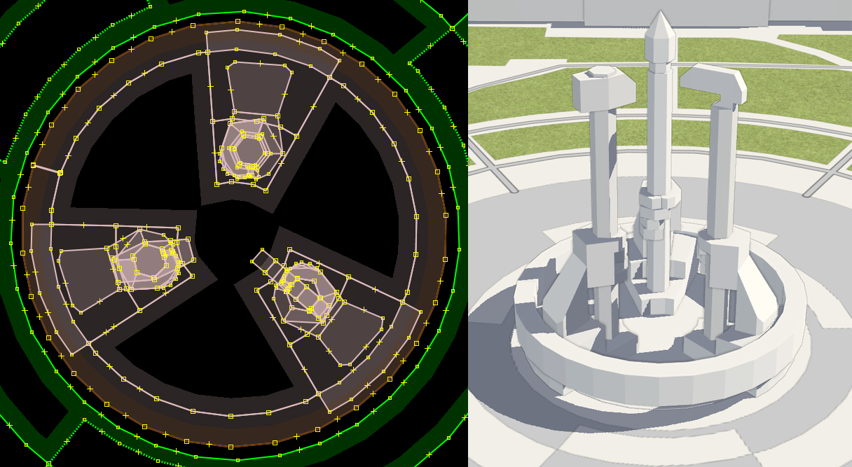
- [1] Koreller explained how he mapped Pyongyang, the capital of North Korea, in 3D. An effort was made to recreate both ordinary buildings and city landmarks in detail. Inspiration for the project came from the popular simulation game ‘Cities: Skylines’.
- Penegal shared
 ► his thoughts on mapping the natural regions of mainland France: what is a natural region? How should they be mapped? What sources should be used?
 - Geozeisig has made a request for comments on
aerodrome=*, a proposal that theaerodrome=*key should be used to classify aerodromes according to their importance and purpose.
 ►
►
Community
- mikeocool stumbled upon an intriguing discovery while mapping Forest Service roads in northwest Montana: two airstrips across the road from each other. Further investigation revealed a backstory involving retired US Navy commander Murland Searight and Hollywood director Michael Cimino.
- Ali Ingersoll, from WRAL-TV, reported that residents of Raleigh, North Carolina, have been mapping pedestrian infrastructure in OSM as volunteers for Code with the Carolinas.
- The UN Mapper of the Month for March 2024 is Pawan Muddu, from India.
Local chapter news
- The OSM-FR association has announced that the 10th SotM France will be held in Lyon from Friday 28 to Sunday 30 June 2024. Detailed information and the call for papers should be available soon.
Maps
- TrailStash has developed OpenBikeHero, an OSM and Overpass powered application for finding bicycle repair stands.
- Rtnf has overlaid weather satellite data onto an OpenStreetMap base map to produce weather forecasts around specific coordinates.
- Sebastian Pertsch found an interesting project – a virtual forum with maps from Saxony, Germany, and the University Library of Dresden. The site has more than 9000 georeferenced historical maps that can be overlaid on a modern OpenStreetMap layer. Some maps were created in the 17th century, which makes this platform even more valuable.
 an interesting project – a
 OSM in action
- By using OpenStreetMap data, Ben Ashforth has devised a mathematical route-planning algorithm in order to visit the streets around Europe that are named after each day of the year.
- Stolpersteine (literally ‘stumbling blocks’) are small brass-plated cubes laid, around Europe, in front of the last-known residences or workplaces of those who were driven out or murdered by the Nazis. Heise Online reported ► that 100,000 such memorial plaques have now been laid of which 30,000 have been recorded in the Stolperstein app. The app is primarily based on OSM data. In OpenPlaques you can find 5786 Stolpersteine, many with a photo. OSM has 33,876 blocks currently mapped.
Programming
- In the year of OpenStreetMap vector maps (we reported earlier), Paul Norman has described his work on minutely updates of a tile server and provided a webpage demo where we can see the result. Developers are invited to test and provide comments.
- Adrien Pavie has shared a tutorial to help users create custom models for object recognition in Panoramax photos. The tutorial walks users through the process of creating a dataset, marking up photos, training the YOLOv8 model, and recognising objects in new photos.
- Mary Knize has developed an OpenStreetMap-based 3D map using the A-Frame framework.
- Using the Monaco example Kamil Raczycki explained, in Towards Data Science, how to use DuckDB to read OpenStreetMap data, while providing insights into nodes, ways, and relations; perfect for SQL enthusiasts looking for streamlined GIS operations with QuackOSM.
- Volker Krause tooted some of their progress on indoor routing in KDE Itinerary and OSM infrastructure for Transitous (a public transport routing app).
Releases
- Joseph Elfelt has released GeoJPG version 2, a web app to display offline maps (we reported earlier).
Did you know …
- … Bexhill’s OSM map, which leaves nothing to be desired? Bexhill-OSM is completely open source. The project is freely available for anyone to review, modify, and improve. Highly recommended for imitation.
- … about the ‘awesome-maplibre‘ GitHub repository? This repository features various projects that use or support MapLibre.
- … the MapLibre webmap Javascript tool? It renders vector maps including 3D models, animations, adding icons, style labels, etc. This open source API is a community led fork derived from mapbox-gl-js that uses WebGL to render interactive maps from vector tiles in a browser. Paul Norman used MapLibre GL for his vector map example in the article above.
- …
HeiGIT has an instance of overpass-turbo that defaults to using their Overpass server?update: the instance is for internal use only
OSM in the media
- Brian Sperlongano described StreetFerret, which uses OSM and Strava data to generate ‘activity completeness’ maps, often resulting in corrections to OSM. StreetFerret’s OSM-based progress tracker for ultra-runner Paul Johnson’s quest to run across the United States was recently featured on a Los Angeles TV news station.
Other “geo” things
- Shaun McDonald raised concerns about proposed traffic solutions in the Ravenswood area of Ipswich, England. He suggests developing alternatives such as walking, cycling, and public transport.
Upcoming Events
| Where | What | Online | When | Country |
|---|---|---|---|---|
| OSMF Membership Drive – March Volunteers Meetup | 2024-03-09 | |||
| Bologna | Open Data Pax 2024 | 2024-03-09 |  | |
| Intramuros | #AlayData sa Intramuros Open Data Day 2024 | 2024-03-10 |  | |
| København | OSMmapperCPH | 2024-03-10 |  | |
| Zürich | 161. OSM-Stammtisch | 2024-03-11 |  | |
| 臺北市 | OpenStreetMap x Wikidata Taipei #62 | 2024-03-11 |  | |
| Rennes | Cartopartie “Places PMR” du Master SIGAT | 2024-03-12 |  | |
| Salt Lake City | OSM Utah Monthly Map Night | 2024-03-13 |  | |
| Berlin | Missing Maps – DRK Online Mapathon | 2024-03-12 |  | |
| Hamburg | Hamburger Mappertreffen | 2024-03-12 | | |
| Plano Piloto | Encontro OSM Brasil | 2024-03-12 – 2024-03-13 |  | |
| Autelbas | OSM Belgium – Ardenne belge – Réunions des contributeurs | 2024-03-12 |  | |
| Potsdam | Radnetz Brandenburg Mapping Abend #3 | 2024-03-13 | | |
| Lorain County | OpenStreetMap Midwest Meetup | ✓ | 2024-03-14 | |
| Berlin | 189. Berlin-Brandenburg OpenStreetMap Stammtisch | 2024-03-14 | | |
| Bochum | Bochumer OSM-Treffen | 2024-03-14 | | |
| München | Münchner OSM-Treffen | 2024-03-14 | | |
| Stainach-Pürgg | 12. Österreichischer OSM-Stammtisch (online) | 2024-03-14 |  | |
| Hannover | OSM-Stammtisch Hannover | 2024-03-15 | | |
| Chemnitz | Chemnitzer Linuxtage | 2024-03-16 – 2024-03-17 | | |
| Perth | Social Mapping Saturday: QEII 2024 | 2024-03-16 |  | |
| Defence Colony Tehsil | 6th OSM Delhi Mapping Party | 2024-03-17 |  | |
| England | OSM UK Chat | 2024-03-18 |  | |
| Lyon | Réunion du groupe local de Lyon | 2024-03-19 | | |
| Strasbourg | Apéro OpenStreetMap | 2024-03-19 | | |
| Bonn | 173. OSM-Stammtisch Bonn | 2024-03-19 | | |
| San Jose | South Bay Map Night | ✓ | 2024-03-20 | |
| City of Edinburgh | OSM Edinburgh pub meetup | 2024-03-19 | | |
| Map-py Wednesday | 2024-03-20 | |||
| Karlsruhe | Stammtisch Karlsruhe | 2024-03-20 | | |
| Bremen | Bremer Mappertreffen | 2024-03-25 | |
Note:
If you like to see your event here, please put it into the OSM calendar. Only data which is there, will appear in weeklyOSM.
This weeklyOSM was produced by Elizabete, PierZen, SeverinGeo, Strubbl, TheSwavu, barefootstache, darkonus, derFred, renecha, rtnf.
We welcome link suggestions for the next issue via this form and look forward to your contributions.