04/02/2020-10/02/2020
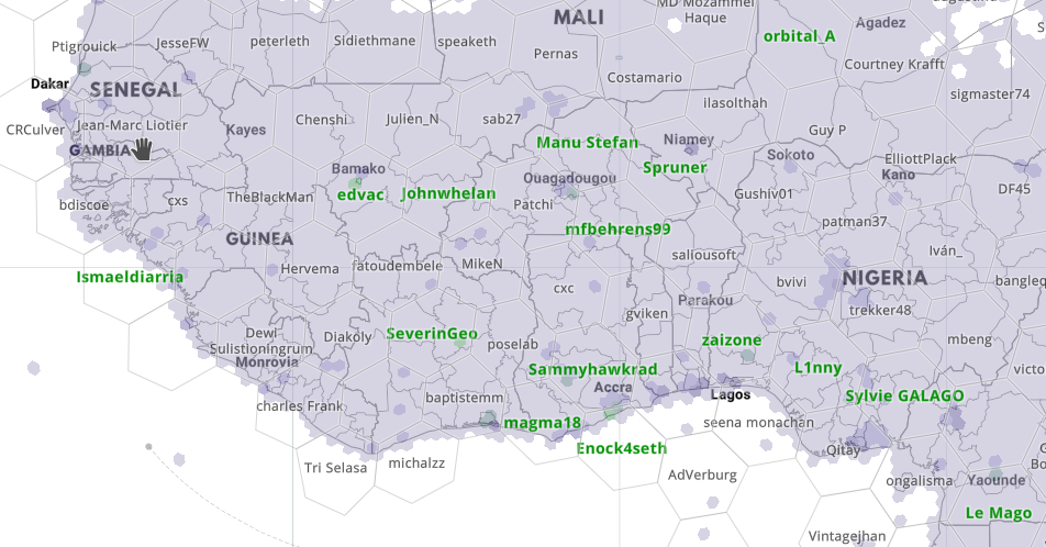
OpenStreetMap mapping activity layer by Kontur 1 | © Kontur, Mapbox | © map data OpenStreetMap contributors
Mapping
- Jinal Foflia shared a MapRoulette task to add street names in the regions around Jakarta, as well as a task to add missing sidewalks in Singapore to make the Singapore map more pedestrian-friendly.
- Mateusz Konieczny suggested using
amenity=facultyas he thinks that university faculties often deserve to be mapped separately. Comments in the discussion raise various issues with the naming of constituent parts of universities. (Nabble) - The European Water Project continues its efforts to improve the tagging schema for drinking-water related tagging. Stuart from the project started the voting on the proposal for
drinking_water:refill=<yes/no>anddrinking_water:refill_scheme=<scheme-name/multiple>. - Joseph Eisenberg suggested improving the tagging system for micromapping as he thinks that the current tags aren’t quite right for this purpose. (Nabble)
- The voting for
amenity=give_box, an amenity where you can share various types of items freely, has ended with an unclear result as it seems it is ambiguous how ‘abstain’ should be counted. - Ilya Zverev reports
 (automatic translation) a large amount of editorial work (reverts including deletion of old object versions) has started in Russia. About 600 organised unknowns (probably Rostelecom) have taken data from unauthorised sources. Presumably, in preparation for this year’s census, buildings and addresses were cribbed from unauthorised sources in an organised way.
 (automatic
 Community
- The first meeting of the Diversity and Inclusion Special Committee was held on 12 February. Mikel Maron posted some rough notes on what came out of the meeting.
- Heather Leson reported on her time spent at FOSDEM 2020, particularly the community and legal sessions. She was pleased to see that Ilya Zverev’s talk on reverse geocoding is available online, as his talk was to a full room.
OpenStreetMap Foundation
- The OSMF invited people to join the OpenStreetMap diversity mailing list. They also asked for help in translating their blog posts to languages other than English.
Events
- Nick Whitelegg brought to the notice of the talk mailing list readers the Panorama Mapping Party with TrekView, a not-for-profit organisation which aims to capture panoramas. The event will take place on 2 May 2020 at the English village Ashurst, in Hampshire.
- Stefan Keller from the HSR University of Applied Sciences Rapperswil invites (automatic translation) you to the 12th Mapathon and Mapping Party to be held on 24 April 2020 in Rapperswil, Switzerland. The invitation is also extended to English-speaking mappers and beginners.
- FOSS4G-IT 2020, an event dedicated to Free and Open Source Geographic Data and Software, will take place from 18 to 22 February 2020 at the Politecnico di Torino / Turin, Italy.
 (automatic
 Humanitarian OSM
- Warin has the impression that HOT is using the undocumented tag
damage=and contacted the HOT mailing list with his observation. - EurekAlert, a non-profit news-release distribution platform, features an article about the three finalists of ‘Creating Hope in Conflict’, a challenge supported by the US Agency for International Development, the UK Department for International Development, and the Ministry of Foreign Affairs of the Netherlands. The goal is to help the vulnerable and hardest-to-reach people affected by humanitarian crises.
- The website thenextweb.com reported about the efforts of scientists to develop an AI-based tool that can help find safe routes after a disaster strikes, enabling families to find each other.
Education
- Jez Nicholson made “OSMUK-in-a-box”, his own toolchain for querying OSM data for the UK from a database, available at GitHub.
Maps
- Andrei Kashcha’s ridgeline map, which we have recently written about, now allows you to set bounds for the map.
- Hans van der Kwast gave a tutorial on how to resolve hydrological discrepancies in DEMs by using ‘stream burning’. The tutorial uses QGIS combined with stream network data from OSM and SRTM data downloaded from the USGS Earth Explorer.
- Russ Garret, the creator and maintainer of OpenInfraMap, announced on Twitter that OpenInfraMap now links power infrastructure to Wikipedia and uses images from Wikidata where available. Links have also been added to the UK’s Renewable Energy Planning Database.
- Plamen Pasliev made a prototype available which scrapes listings from one of the largest German real estate portals. It uses Google services to geolocate the listings and nearby amenities and provides results on an OSM-based map.
Programming
- Chris Beddow, from Mapillary, blogged about the possibilities of working with Mapillary data in Jupyter Notebooks.The hands-on guide explains how to access the Mapillary APIs and work with images, image sequences, and (if you’ve paid the subscription for map data) with features such as traffic signs, crosswalks, utility poles and pavement markings.
Did you know …
- …. the OpenStreetMap mapping activity layer from Kontur, which shows how actively every place in the world is mapped and which mapper is most active there?
- … that OpenMapTiles supports more than 50 languages? The names are taken from OpenStreetMap and enhanced by adding data from Wikidata.
- … that OSM is used on the website coronavirus.app, which shows where the corona virus has been found.
Other “geo” things
- Several media outlets such as the Indian Hindustan Times and the German Der Spiegel (automatic translation) featured the 15th birthday of Google Maps in articles describing the service and its history. Jen Fitzpatrick, Senior Vice President at Google Maps, also recaps the development from Google’s perspective in her blog.
- A map of South-east England with places names spelt phonetically in Polish was recently tweeted. It is presumed that the map was created to assist the many Polish pilots in the Royal Air Force during the Second World War.
- Morgan Herlocker, of SharedStreets, and formerly of Mapbox, uses the example of the recent artistic exploitation of Google’s real-time traffic algorithm (as we reported), to explain some of the issues involved in turning traffic sensor data into something usable by road users.
- A detailed Twitter thread on cycleway provision in the British city of Leicester, provides a good introduction to a lot of detailed terminology which might be of interest to dedicated micro-mappers.
- A new minimum distance of 1.5 m will soon apply in Germany when overtaking cyclists. This distance calculator can be used to estimate how close an overtaking vehicle was in a bicycle camera shot.
- To some graffiti is a cultural asset and an important aspect of a city’s aesthetics; to others it’s vandalism. A team from Heidelberg University’s GIScience Research Group have developed a deep learning approach to detect building facades with graffiti artwork based on the automatic interpretation of images from Google Street View.
- Barrington-Leigh and Millard-Ball’s paper on urban sprawl (which we covered earlier) received more coverage, this time in an article on CityLab. The article points to the authors’ sprawl map and provides us with the fact that there are 10,845,867 dead ends mapped in OSM.
- bikeradar reviewed the OS Trail 2 Bike GPS and found it a frustratingly flawed device that doesn’t merit its £400 price tag and provides little incentive for choosing it over a Garmin. Of particular interest was the finding that: ‘[d]evices that use OpenStreetMap provide much greater detail and include details such as mountain bike tracks. OS map data doesn’t have this level of granular information, rendering it fairly incompatible with your average trail centre rider.’
Upcoming Events
| Where | What | When | Country |
|---|---|---|---|
| Karlsruhe | Karlsruhe Hack Weekend February 2020 | 2020-02-15-2020-02-16 |  |
| Mainz | Mainzer OSM-Stammtisch | 2020-02-17 | |
| Viersen | OSM Stammtisch Viersen | 2020-02-18 | |
| Derby | Derby pub meetup | 2020-02-18 |  |
| Cologne Bonn Airport | 126. Bonner OSM-Stammtisch | 2020-02-18 | |
| Lüneburg | Lüneburger Mappertreffen | 2020-02-18 | |
| Turin | FOSS4G-it/OSMit 2020 | 2020-02-18-2020-02-22 |  |
| Ulmer Alb | Stammtisch Ulmer Alb | 2020-02-20 | |
| Rennes | Atelier découverte | 2020-02-23 |  |
| Takasago | Takasago Open Datathon | 2020-02-24 |  |
| Singen | Stammtisch Bodensee | 2020-02-26 | |
| Düsseldorf | Düsseldorfer OSM-Stammtisch | 2020-02-26 | |
| Lübeck | Lübecker Mappertreffen | 2020-02-27 | |
| Brno | Únorový brněnský Missing maps mapathon na Geografickém ústavu | 2020-02-27 |  |
| Toulouse | Contrib’atelier OpenStreetMap | 2020-02-29 | |
| Budapest | Budapest gathering | 2020-03-02 |  |
| London | Missing Maps London | 2020-03-03 | |
| Stuttgart | Stuttgarter Stammtisch | 2020-03-04 | |
| Praha/Brno/Ostrava | Kvartální pivo | 2020-03-04 | |
| Dortmund | Mappertreffen | 2020-03-06 | |
| Riga | State of the Map Baltics | 2020-03-06 |  |
| Amagasaki | GPSで絵を描いてみようじゃあ~りませんか | 2020-03-07 | |
| Freiburg | FOSSGIS-Konferenz | 2020-03-11-2020-03-14 | |
| Chemnitz | Chemnitzer Linux-Tage | 2020-03-14-2020-03-15 | |
| Valcea | EuYoutH OSM Meeting | 2020-04-27-2020-05-01 |  |
| Guarda | EuYoutH OSM Meeting | 2020-06-24-2020-06-28 |  |
| Cape Town | HOT Summit | 2020-07-01-2020-07-02 |  |
| Cape Town | State of the Map 2020 | 2020-07-03-2020-07-05 | |
Note: If you like to see your event here, please put it into the calendar. Only data which is there, will appear in weeklyOSM. Please check your event in our public calendar preview and correct it, where appropriate.
This weeklyOSM was produced by Polyglot, Rogehm, SK53, SunCobalt, TheSwavu, YoViajo, derFred.