12/04/2022-18/04/2022
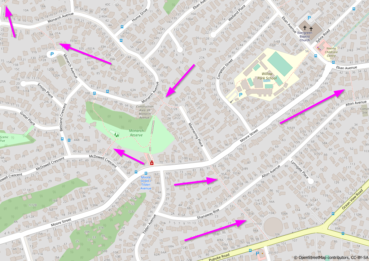
Identification of missing pedestrian accessways [1] © CoyKoi | map data © OpenStreetMap contributors
About us
- We are always looking for people to help us improve our newsletter so it can get out faster, have more depth and coverage, and generally improve it for our readers, like you. You may see in this issue that some articles are not sufficiently described. We are urgently looking for people who are willing to help write such articles. Get in touch via info at weeklyosm dot eu.
Mapping
- w_wie_waldi wrote
 > , in his blog, about how to map unofficial bike paths, those paths not signed as bike facilities, rather paths that are separated or not separated pavements (sidewalks), especially in out of town areas.
 >
> 
Community
- CoyKoi (a NZ based mapper) described the process they used to identify and add missing pedestrian access ways in Auckland.
- Martijn van Exel explained how to get in touch with local mappers using the online Meet Your Mapper tool to get a list of contributors and their OSM activity profile.
OpenStreetMap Foundation
- The OpenStreetMap Foundation (OSMF) has hired a full time Site Reliability Engineer who starts work on 1 May. The OSMF will make an official announcement in a few days.
Events
- The organisers of State of the Map 2022 have made a call for abstracts for the Academic Track.
- Just a reminder that the deadline for talk, workshop and panel submissions for SotM 2022 is 25 April 2022 at 23:59:59 UTC.
Humanitarian OSM
- The HOT Summit working group announced a new approach to the design of the HOT Summit conference for 2022 and 2023, focusing on supporting community events and conferences through collaborations and co-hosting. Feedback and event collaboration suggestions are welcome.
Maps
- Levi Westerveld shared his insights about the changes in map symbology used by the New York Times in their coverage of the war in Ukraine.
- The US Department of Transportation has created a map showing transportation (aviation, road and rail) related noise pollution throughout the country from 2016 to 2018.
- Back in 2017, Schollz created the website MakeMyDriveFun. Using OpenStreetMap through Leaflet (unfortunately not up with the current recommendations for attribution), the website suggests interesting features within 20 driving minutes, from any custom route.
Software
- Anton Khorev wrote, in his diary, about his note-viewer and integrating it with JOSM and iD to allow editing.
- In 2017, Seth Fitzsimmons described how to query OpenStreetMap with Amazon Athena.
Programming
- Travis Hathaway wrote about processing OpenStreetMap data using PostgreSQL and Python.
Did you know …
- … you can query POIs in a given area with a GUI using OpenPoiMap?
- … about uptime.openstreetmap, where information about current availability of OpenStreetMap is displayed?
Other “geo” things
- MoSarwat highlighted the importance of spatial joins in geospatial analysis, by allowing comparisons between geographic datasets.
- Tom MacWright outlined his impressions of Hivemapper’s intention to transition from drone mapping to dash cam mapping and their plan to pay image contributors with a crypto-currency.
- Note: 2939310 | OpenStreetMap
- Saez Consulting Engineers use an interesting setup for their 3D surveying technology which requires ground drawn rectangles as reference points.
Upcoming Events
| Where | What | Online | When | Country |
|---|---|---|---|---|
| Earth Day #earthday | 2022-04-22 – 2022-04-24 | |||
| 新店區 | OpenStreetMap 街景踏查團 #1 | 2022-04-24 |  | |
| 京都市 | 京都!街歩き!マッピングパーティ:第29回 Re:鹿王院 | 2022-04-24 |  | |
| Open Mapping Hub Asia Pacific OSM Help Desk | 2022-04-25 | |||
| OSMF Engineering Working Group meeting | 2022-04-25 | |||
| Bremen | Bremer Mappertreffen (Online) | ✓ | 2022-04-25 |  |
| [Online] OpenStreetMap Foundation – Board of directors and advisory board public videomeeting | 2022-04-26 | |||
| San Jose | South Bay Map Night | ✓ | 2022-04-27 |  |
| Open Mapping Hub Asia Pacific OSM Help Desk | 2022-04-27 | |||
| Düsseldorf | Düsseldorfer OpenStreetMap-Treffen | ✓ | 2022-04-27 | |
| Roma Capitale | Incontro dei mappatori romani e laziali | 2022-04-27 |  | |
| Decatur County | OpenStreetMap US Mappy Hour | 2022-04-28 | | |
| [Online] OpenStreetMap Foundation board of Directors – public videomeeting | 2022-04-28 | |||
| Paris | Cartopartie “Fing Data Day” | 2022-04-28 |  | |
| Gent | Open Belgium 2022 | 2022-04-29 |  | |
| Rapperswil-Jona | Mapathon/Hackathon at the OST Campus Rapperswil and virtually | 2022-04-29 |  | |
| Gent | OpenStreetMap Belgium IRL meetup | 2022-04-29 | | |
| IJmuiden | OSM Nederland bijeenkomst (online) | ✓ | 2022-04-30 |  |
| Greater London | Missing Maps London Mapathon | 2022-05-03 |  | |
| Berlin | OSM-Verkehrswende #35 (Online) | ✓ | 2022-05-03 | |
| Boa Viagem | BOA VIAGEM(CE) BRASIL – EDIFÍCIOS, ESTRADAS, PONTOS DE INTERESSE E ÁREA VERDE. | 2022-05-07 – 2022-05-08 |  | |
| Bogotá Distrito Capital – Municipio | Notathon en OpenStreetMap – resolvamos notas de Latinoamérica | 2022-05-07 |  | |
| San Jose | South Bay Map Night | ✓ | 2022-05-11 | |
| München | Münchner OSM-Treffen | 2022-05-11 | | |
| Salt Lake City | OSM Utah Monthly Meetup | 2022-05-12 | | |
| Michigan | Michigan Meetup | ✓ | 2022-05-12 | |
Note:
If you like to see your event here, please put it into the OSM calendar. Only data which is there, will appear in weeklyOSM.
This weeklyOSM was produced by Lejun, Nordpfeil, PierZen, SK53, Sammyhawkrad, Strubbl, TheSwavu, derFred, ilginozemir.