20/06/2023-26/06/2023

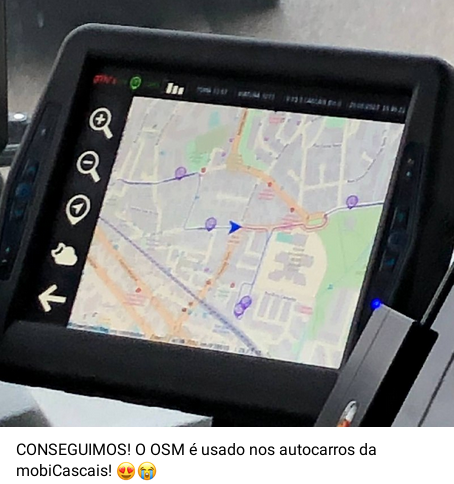
OSM is in use on public transport in Cascais, Portugal [1] © Diogo Baptista © Contribuintes OpenStreetMap
Mapping
- EnumMapper has posted a diary with links to two videos that show tracing the process of highway and mountain woods with a drawing tablet.
- Mateusz Konieczny has documented, on the OSM Wiki, the shop=eggs tag, for a shop selling only or primarily this specific type of food.
- The
line_arrangement=*proposal for mapping the arrangement of power lines is now open for voting until Wednesday 5 July.
Community
- Andrii Holovin has shared an implementation of multilanguage support for Switch2OSM that is ready to use. This implementation includes extra features like a day/night theme switcher, search functionality, and syntax highlighting. He has also set up a Transifex project for translations and is open to helping with integrating this work into the main repository.
- InfosReseaux wrote a blogpost to improve awareness about the importance of tagging. They explained how the tagging scheme is at least as valuable as the data in OpenStreetMap.
- Mikko Tamura shared the work of RainbOSM, MapBeks, and the HOT Open Mapping Hub Asia Pacific on ways to celebrate Pride Month on OpenStreetMap with LGBTQ+ themed tags and advice in making your mapathons LGBTQ+ friendlier.
- Rtnf reported that the ‘OSM Cultural Spheres Group’ was launched on Telegram. As a community for OSM contributors with limited English proficiency, everyone there is encouraged to speak their own native language.
- Tobias Jordans blogged about generating aerial imagery from 360° point clouds and compared it to using phone lidar technology.
OpenStreetMap Foundation
- Mateusz Konieczny is updating the list of OpenStreetMap map data users found to be in violation of the licence and is seeking help in reviewing the list.
Local chapter news
- Following an informal AGM
held during SotM France
►
on 10 June, the statutory AGM
►
of the OSM France association was held online on Friday 30 June at 9 pm. A new 12-member Board of Directors was elected for a one-year term.
Events
- Video footage of the State of the Map France 2023 has been released. These videos are available on peertube
.
Maps
- MapTiler noted that MapTiler Outdoor has long-distance trails visible on higher zoom levels to help you plan your summer bike trip.
- Steve Attewell is developing a place-finding AI chatbot using OpenStreetMap data. The app is still in development and has not yet been released to the public.
switch2OSM
- [1] User Diogo Baptista announced, on the Telegram channel of the OSMPortugal group, that MobiCascais
►
is using OSM on its public transport network. MobiCascais is the integrated sustainable mobility management system of the Portuguese town of Cascais, based on an integrated platform of various public transport service operators (buses, taxis, bicycles, car parks, and charging stations for electric vehicles).
Programming
- Oliver Spies wrote an article about how to use OpenStreetMap data for self-hosted, self-styled, privacy-friendly interactive web maps using vector tiles. For many websites this approach may be an alternative to using Google Maps.
Releases
- The release of the OSM Element Vectorisation Tool (OEV) by GIScience Heidelberg (we reported earlier) was accompanied by a
presentation of possible use cases and specific examples of what the OEV tool can do, as well as a video podcast discussing OSM, data quality, and using the tool. The OEV provides high-resolution data insights into the OSM database by creating a multi-layered view of the data.
Other “geo” things
- The Direção Regional do Ordenamento do Território of the Autonomous Region of Madeira in Portugal is capturing
►
aerial imagery of Madeira, Porto Santo, and Desertas, enabling the maps of these Portuguese territories to be updated.
- Tomas Pueyo explained how maps distort our perception of the world.
Upcoming Events
Note:
If you like to see your event here, please put it into the OSM calendar. Only data which is there, will appear in weeklyOSM.
This weeklyOSM was produced by Elizabete, MatthiasMatthias, NunoMASAzevedo, PierZen, TheSwavu, barefootstache, rtnf.
We welcome link suggestions for the next issue via this form and look forward to your contributions.
Since twitter has moved fully to be a customers-only platform you might want to reconsider linking to them. AFAIK you otherwise don’t link to not publicly accessible pages.
Hi chris, sure. We are discussing this already.
Irish flag not working https://www.weeklyosm.eu/wp-content/uploads/2018/11/ie.svg
And what about Korean and Czech flag? Any border like has Polish flag?
Thank you, the Irish flag is fixed. You need to refresh that image from cache to be able to see the fix.