10/10/2023-16/10/2023
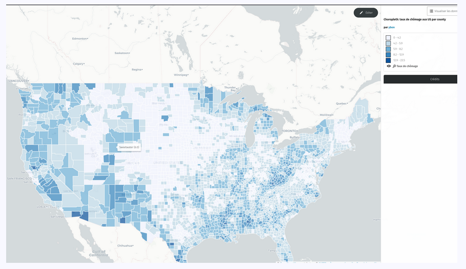
Choropleth layer in uMap [1] © ybon | map data © OpenStreetMap contributors
Mapping
- Spencer Alves attended the dedication of a new park, with a LiDAR-equipped phone, and micromapped the park in OSM. His toot on Mastodon showed that other map providers look pretty outdated in comparison.
- Klenje blogged on the basics of mapping playgrounds. In the comments, Sven Geggus offered to provide the code from OpenCampingMap to anyone interested in creating an OpenPlayGround map.
- The following proposals are waiting for your comment:
- Dieter Dreist‘s proposal suggests that ladders should be mapped directly in OSM rather than with
highway=pathin combination withladder=yes. - Reinhart Previano‘s proposal digital wallet payments V2 is designed to extend the
payment:*tagging scheme to cover payment apps and services as payment methods.
- Dieter Dreist‘s proposal suggests that ladders should be mapped directly in OSM rather than with
Mapping campaigns
- Tourist Information Eichstätt is looking
 ► for help in correcting the hiking trails in OSM. You can find up-to-date GPX tracks on their website.
 ►
►
Community
- Kingsley AMANKWE described his involvement in the SotM Nigeria 2023 as ‘unforgettable, inspiring, and hopeful’.
- Matt_ recounted his experience correcting the location of lakes and dams on OpenStreetMap.
- Mikel Maron is looking for a workflow to make use of the Overture places data in OSM.
- Romeo Ronald wrote a diary post about what mapping Juba, the capital city of South Sudan, means to him and explained the benefits he sees for the community: empowerment, inclusivity, engagement, and innovation.
OpenStreetMap Foundation
- The next monthly public meeting of the OSMF board will take place on Thursday 26 October at 13:00 UTC.
- The OSM Foundation is continuing to ask for a wide range of support. With the current donation drive ongoing, the Foundation is also happy to collect your contribution.
Local chapter news
- Courtney Williamson explained what a Local Chapter is and how to join one.
Events
- The Geomob podcast interviewed Ben Abelshausen, one of the organisers of the State of the Map Europe 2023 event, which will take place next month.
- OpenStreetMap India has joined, as a ‘community partner’, in the free and open-source software conference ‘India FOSS 3.0’, which will take place on 28 and 29 October in Bengaluru.
- Mikel Maron has summarised some of the key messages from the keynote talk he gave at the State of the Map Nigeria 2023.
Education
- The UN Mappers will be offering a new course in Spanish on OpenStreetMap and humanitarian mapping. It will start on Wednesday 1st November and is open to all. Registrations are open until Sunday 29th October.
 are open until Sunday 29th October.
Humanitarian OSM
- Pete Masters gave an update on the disaster response activities for the Morocco (earthquake) and Libya (floods) events. He posted OSM statistics, local data options, and reactions from different organisations.
Maps
- Julien Minet has set up ► a tile server for OpenArdenneMap. It is designed specifically for printing topographic maps in a ‘cartoCSS/Mapnik’ style and has recently been made available as a QGIS style. If you’re looking for ready-to-print maps, you’ll find them at hiking.osm.be.
 ►
►OSM in action
- The meteorologist Jörg Kachelmann, who is very well known in the German-speaking world, is using OSM data for his weather maps. He also uses the correct attribution prescribed by OSM. His data source is easier to see here, for example.
- Akihiko Kusanagi has published ‘Mini Tokyo 3D’, a 3D map that displays the position of trains, planes, and weather around Tokyo in real time. The map uses OpenStreetMap data combined with various related open data.
Licences
- Regin Lippold announced ► that from October 2023, basemap.de products and services will be available under an open data licence. In response to this news, Mcliquid tooted noting that the open data licence in question is CC BY 4.0, which is not compatible with OpenStreetMap’s ODbL licence.
Software
- Rihards Olups tooted that JOSM can now process the .FIT file format used by Garmin GPS devices.
- Vincent de Château-Thierry (vdct contributor) announced ► that the Pifomètre tool (for integrating address points in OSM in France from open data sources) now has a map display called Pifomap .
- HeiGIT announced that SketchMapTool, an application to support paper-based digital mapping activities, has received funding support from the German Red Cross and the German Foreign Office.
Programming
- Nikhil VJ showed how to copy shapes out of vector tiles.
- Riley Walz and Mehran Jalali have made Fuzzy, an AI that uses OSM to answer complicated geospatial queries. For example, “get walking directions to the sweetgreen closest to City Hall and avoid passing by any McDonald’s”.
- OpenCage have released jopencage v2.0.0, a Java SDK to access their geocoding API.
- Ilya Zverik has written cli-oauth2, a Python library for performing OpenStreetMap authentication based on OAuth2.
Releases
- [1] Yohan Boniface, aka ybon, has released uMap version 1.9.2. This version now includes a feature to create choropleth maps.
- MapTiler has released MapTiler Server version 4.4.
Did you know …
- … the opensource-based interactive web map system ‘Protomaps‘?
- … the website that tries to verify that the OSM map is complete? Of course it is not possible, but this website gives metrics on how many of some large store brands have been mapped compared to the number expected. Statistics are also available on the number of museums, sculptures, airports, etc.
- … that you can find and add automated external defibrillator location data to OpenStreetMap using OpenAEDMap?
Upcoming Events
| Where | What | Online | When | Country |
|---|---|---|---|---|
| Lagos | #MapNigeria Monthly Meetup | 2023-10-21 | ng | |
| Chambéry | Mapathon débutant saison 23/24 CartONG | 2023-10-23 |  | |
| San Jose | South Bay Map Night | ✓ | 2023-10-25 |  |
| Wien | 69. Wiener Stammtisch | 2023-10-25 |  | |
| Düsseldorf | Düsseldorfer OpenStreetMap-Treffen | 2023-10-25 |  | |
| [Online] OpenStreetMap Foundation board of Directors – public videomeeting | 2023-10-26 | |||
| Lübeck | 136. OSM-Stammtisch für Lübeck und Umgebung | 2023-10-26 | | |
| Bengaluru | IndiaFOSS 3.0 – OSM Workshop | 2023-10-27 – 2023-10-28 |  | |
| Signa | OpenStreetMap al Linux Day di Signa (Firenze) | 2023-10-28 |  | |
| Saint-Étienne | Rencontre Saint-Étienne et sud Loire | 2023-10-31 | | |
| OSMF Engineering Working Group meeting | 2023-11-01 | |||
| Stuttgart | Stuttgarter OpenStreetMap-Treffen | 2023-11-01 | | |
| IJmuiden | OSM Nederland bijeenkomst (online) | 2023-11-01 |  | |
| Thrissur | OSM Kerala Annual Community Meetup 2023 | 2023-11-03 – 2023-11-04 | | |
| Dublin | OpenStreetMap Ireland AGM | 2023-11-04 |  |
Note:
If you like to see your event here, please put it into the OSM calendar. Only data which is there, will appear in weeklyOSM.
This weeklyOSM was produced by MatthiasMatthias, Michael Montani, Strubbl, TheSwavu, barefootstache, derFred, rtnf.
We welcome link suggestions for the next issue via this form and look forward to your contributions.