17.02. – 23.02.2015

Mapping
- The proposal for waste=* has a new name and has waste_collection=* as a new main key. Attempts have been made to unify various waste disposal and recycling tags.
- Brad Neuhauser proposes the tag portage=* for portages on the tagging list . Portages are stretches where canoes can bypass weirs, rapids or other obstacles.
- There is a long, if convoluted, discussion about “fixme” tags on the main “Talk” mailing list.
- RobJN describes in his blog the easy approach for locating and removing incorrect street names in the UK.
- Some users do not receive emails (English) when their changesets are commented on by others.
- On April 25 in Brussels, Belgium, there will be a mapping party . The party aims to provide help for new mappers from those who have more advanced skills, and to focus on improving opencyclemap and wheelmap. Everyone is welcome.
- As part of a broader civic campaign centered on “children’s clubs”, groups of children are creating detailed “social maps” of their marginalised neighbourhoods to voice their concerns about issues linked to public spaces. Much of the child-led mapping campaign sweeping India today relies on old-school topography materials.
Community
- The French community is working together to trace the 2 054 new cantons (formerly, there were 4035). Official decrees are currently being published… the challenge is to be ready before the nationwide polls on March 22nd and 29th.
- A hackathon election was held by the Institute of Political Studies Sciences Po, the Interior Ministry and Etalab on February 23.
- MapBox has had its signalling function “Improve this map” revised and describes how to deal with these error messages.
- Mapillary data usage on OSM from pizzaiolo.
- User: Geoallrounder talks about his project Road Conditions BW. (Botswana)
- User dudone did not quite reach his 3-year target. The target, however, had been increased and he has done a lot.
- Marco Antoino talks on the Latinamerican mailing list (English) about a possible regional SotMLa in 2015 because the SotM 2015 was cancelled.
Imports
- Apparently, the Nepalese Red Cross has imported personal related data into OSM.
- In Vorarlberg, Austria, geographical names were imported without notice. The legal situation is not entirely clear.
- “what a shame http://www.openstreetmap.org/changeset/29037848 … 🙂 #openstreetmap” von @sp8962. Link in changeset. (Link in English)
OpenStreetMap Foundation
- OSM.org blog reports on the personal meetings of the Board of OSM Foundation.
- The Russian Tile CDN is overloaded.
- The OSMF server finally got a new TLS certificate with a stronger hash.
Humanitarian OSM
- There will be a mapping party on March 7 in Abobo, Côte d’Ivoire, . To support the project an issue was created on HOT Tasking Manager.
- The UN Mission for Ebola Emergency Response (UNMEER) launched a web map application for Liberia. Various layers of information are presented with OpenStreetMap as the basemap. (via Pierre Béland)
Maps
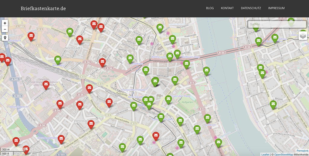
- [1] Danilo Bretschneider describes in detail in his blog how he has “built” his postbox map (this is very useful for beginners!)
- The Taglocator from marczoutendijk has been renamed as “OpenPoiMap” and has its own domain: openpoimap.org.
- The Ile-de-France in comics, “mapped with open source” (Englisch), more precisely on uMap with more than 70 locations from comics. (via Thevenon)
Open-Data
- “The scarcely discussed potential of Open-source data” is available on dbresearch.de (English).
- “Data for all” from Oliver Fuchs auf nzz.ch (English).
- Difference with OpenStreetMap? from the forum OpenAddressesUK.
- Nepal celebrated Open Data Day for the third time. This year’s Open Data Day was special because it had a special emphasis on open map data and was themed “Open Data and Map for Local Governance and Civic Participation”. The event was co-organized by Kathmandu Living Labs, a non profit tech company working to promote OpenStreetMap in developing countries.
Licenses
- Great Britain’s national mapping agency the Ordnance Survey has switched to OGL. They’ve also adopted a snazzy new logo, and in the process have gained a parody Twitter account. Read more here.
Software
- An Open Source Landsat Browser, Libra. from Astro Digital is now available
- Using RStudio as an interactive GIS with Leaflet from Kyle Walker
- Self-hosting Mapbox vector tiles on gis.stackexchange.com
- The Overpass API has its own developer mailing list. More information here.
- Google open sources a MapReduce framework for C/C++ from Derrick Harris
- Tommaso Urli describes in his blog, how to set up an OSRM server on Ubuntu 14.04.
- lat lon lat lon lat lon lat – Tom MacWright uses a table to show in which file formats or interfaces the first value is the longitude and the second the latitude, and in which ones it is the other way around.
- Tapping into OpenStreetMap Metadata via @developmentseed
Have you come across …
- … the master thesis from Kirchmayr-Novak “Bewertung der Datenqualität der OpenStreetMap als Datengrundlage für einen Verkehrsgraph mit Hilfe offener Daten und Software”? The abstract is in English. The title of the thesis: Evaluating the quality of OSM data as the basis for traffic graph data, with the help of open-source data and software”
- … TRAVIC, the transit visualisation client, developed by geOps in collaboration with the University of Freiburg?
- … the Veggiemap?
Other “geo” things
- Tech and data converge to create better maps about our shared worlds from Alex Howard
- The Android app from Mapillary has been thoroughly revised and is available in version 1.0.
- Google Now starts showing gas stations along your route.