06/04/2021-12/04/2021
EqualStreetNames project [1] | Website and data process built by Open Knowledge Belgium and SPRL GEO-6 BVBA| map data © OpenStreetMap contributors
Mapping campaigns
- In March, EqualStreetNames.Leipzig started to link the streets of Leipzig (Germany) in OSM with their namesakes’ Wikidata entries. The next project day is Sunday 25 April from 8:00 am UTC. If you want to participate in the online meeting and help to complete the tag landscape of Leipzig, please write to fey_kuehn@posteo.de for further information.
- OpenStreetMap US is calling for ideas and session proposals for MappingUSA, their virtual spring conference. Whether you’re new to OSM or have been a contributor since the beginning, they want to hear from you! Submit your proposal here. The deadline is Friday 23 April.
Mapping
- SwiftAddress is an application designed to be able to efficiently collect house numbers for OpenStreetMap. While available on GitHub, it’s planned to be released in app stores soon.
- April brings two international commemorative days that offer fun ideas for mapping. Earth Day on Thursday 22 April demonstrates support for environmental protection, and the less well-known International Day of Human Space Flight, which is 12 April, proclaimed by the United Nations in 2011, fifty years after Yuri Gagarin’s first human space flight. You can continue to support OSM by using earth observation imagery.
- The MapRoulette blog has a new guest post about mapping reservoirs in the United States, written by Brian Spergolano. Many reservoirs in the US were imported years ago as nodes. This challenge asks mappers to add missing reservoirs as polygons, remove those that no longer exist, and generally help improve water mapping in the USA. The challenge is also featured at MapRoulette.
- Six members of OSM Mauritania have GPS traced the entire public transport network in the capital, Nouakchott, including informal transit. The result: the first interactive map for the city’s bus and taxi routes.
- Requests have been made for comments on the following proposals:
- Facade garden – for tagging miniature gardens built against a building facade in an urban area with
garden:type=facade_garden - Fossil – for tagging a fossil, either naturally occurring, as a part of a construction, or as a fixed artefact, with
natural=fossil
- Facade garden – for tagging miniature gardens built against a building facade in an urban area with
- The proposal to replace
landuse=forestbyboundary=forestryis open for voting until Tuesday 20 April. The turnout is already much higher than usual (109 votes at the time of publication) and the results so far indicate that the topic belongs to the class of the more controversial issues in OSM. - Voting has ended for the following proposals:
trailblazed=poles;cairnswas approved with 22 votes for, 0 votes against, and 3 abstentions.highway=buswaywas approved with 36 votes for, 5 votes against, and 1 abstention.
Imports
- After weeks of discussion, elaboration and the presentation of an import proposal, the Portuguese OpenStreetMap group will start importing national addresses based on the free use database of the National Statistics Institute. For more information, consult the project’s wiki page
 > or the group’s official channel on Telegram.
 >
> 
Local chapter news
- OpenStreetMap US announced Mapping USA, a free virtual event that will take place on 20 to 22 May. Mapping USA will include an informal Mappy Hour on Thursday, a half day of talks on Friday, and a day of workshops, birds of a feather sessions and mapathons on Saturday.
- Mappers from the Poitou-Charentes region, in France, will hold an online meeting on Wednesday 21 April at 6:30 pm.
 on Wednesday 21 April at 6:30 pm.
Education
- HeiGIT and German Red Cross have published > further training material for mapathons.
 >
> OSM research
- In a YouTube video, Reeniz shows us the numerical evolution of mapped buildings in Latin American countries from 2007 to today.
Humanitarian OSM
- A UK contributor used MapUganda to create Humanitarian Mapping tasks for Merthyr Tidfil, Wales in the UK and justified their changes by citing the most alarming COVID-19 metrics in the UK. UK contributors were not consulted prior to these actions and some contributors are upset by the lack of communication and transparency, and poor mapping quality, such as retagging residential roads as motorways (example) (see discussion). Richard Fairhurst asked that the mapping activity be paused. He doubts the rationale of the task because the local Director of Public Health should have access to authoritative building footprints. It appears the projects have now been removed from the tasking manager.
- HOT’s Community Support Manager, Sophie Mower, shared feedback received from microgrant applicants and community members on the new mentorship program for applicants, which helped them to strengthen and refine their applications.
Maps
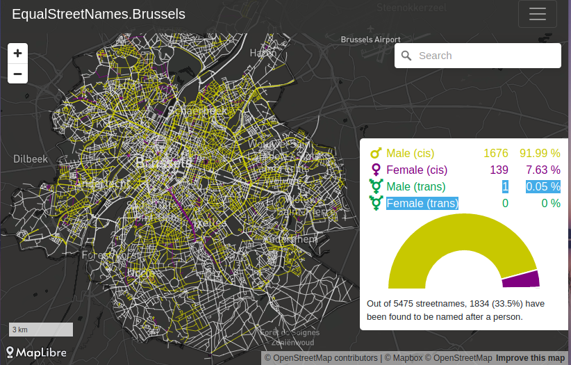
- [1] The overview map of the EqualStreetNames project shows the 17 cities currently participating, from Belgium (9), Germany (5), the Netherlands (2), and Serbia (1). Each of the city street maps shows, in distinguishable colours, the gender of the person the street is named after, and the Wikipedia and Wikidata links. The GitHub repository explains in detail how to create one for a city of your choice.
- WOM, mobile and Internet provider in Colombia, has an OSM-based map that shows the coverage and quality of its G3 and LTE network.
- OpenPoiMap (formerly Taglocator) is a web application, created by Marc Zoutendijk, that helps you find various tags of interest, also called points of interest, on OpenStreetMap.
 an OSM-based map that shows the coverage and quality of its G3 and LTE network.
Software
- Mishari, a moderator of the Thai OSM forum, had a very positive first experience of mapping with StreetComplete. They ask if people are interested in a localisation hackathon to provide a Thai translation for the app.
- Foto-Entwerter is a tool, created by Michael Reichert, to black out faces and number (licence) plates from a large number of photos in a manual but efficient way for a large number of photos. Especially useful to avoid leaking personal information when uploading pictures.
Did you know …
- … if you feel bored during the lockdown, ImproveOsm can help by pointing to probable missing features for you to map? The tool exists both as a plug-in for JOSM and as an iD layer.
- … the German OSM server hosts a map that displays the values of
opening_hoursin a pleasing, human-readable way? It also allows the user to switch to more uncommon tags such asopening_hours:kitchen,smoking_hours, andcollection_times.
Other “geo” things
- Sofia Moutinho interviewed Carlos Doviaza, a young mapper making maps to help Panama’s indigenous communities deal with various issues, including the ongoing COVID-19 pandemic.
- The district committee from the Munich suburb of Berg am Laim, Germany, received > a refusal for ‘organisational and financial reasons’ from the city’s map application team regarding the addition of public benches (the required data is not currently available in a digital form) .
- The Africa GeoPortal tweeted an introduction to the NigeriaGeoPortal. The portal provides a lot of CC-BY licensed datasets, with OSM as a basemap.
- French archaeologists have uncovered a stone with 4,000-year-old etchings they believe may be the oldest three-dimensional map found in Europe. The engravings on the Saint-Bélec Slab resemble topographical features including hills and a river network with a match rate of 80% along a 29 km stretch of the L’Odet.
Upcoming Events
| Where | What | Online | When | Country |
|---|---|---|---|---|
| Área metropolitana de Madrid y Corredor del Henares | OSM training | 2021-04-20 |  | |
| OSM Duma: Talking about OmsAnd business card, landing page, event scheduling | 2021-04-20 | |||
| 138. Treffen des OSM-Stammtisches Bonn | 2021-04-20 | |||
| City of Nottingham | OSM East Midlands/Nottingham meetup (online) | ✓ | 2021-04-20 | gb |
| Berlin | OSM-Verkehrswende #22 (Online) | 2021-04-20 |  | |
| Lüneburg | Lüneburger Mappertreffen (online) | 2021-04-20 | | |
| Albuquerque | MapABQ April virtual meetup | 2021-04-22 |  | |
| Área metropolitana de Madrid y Corredor del Henares | JOSM training | 2021-04-21 | | |
| Missing Maps DRK Online Mapathon | 2021-04-21 | |||
| Chicago | Loyola University Chicago Friends of MSF Earth Day Mapathon | 2021-04-23 | | |
| Weggis | Swiss OpenStreetMap Association Annual General Meeting | 2021-04-23 |  | |
| gmina Krośniewice | Virtual meeting of the Polish OSM Association | 2021-04-23 |  | |
| 臺北市 | 開發者地圖大亂鬥 | 天瓏書局 | 2021-04-24 |  |
| Bremen | Bremer Mappertreffen (Online) | 2021-04-26 | | |
| Área metropolitana de Madrid y Corredor del Henares | Mapatón Madrid streets | 2021-04-27 | | |
| Düsseldorf | Düsseldorfer OSM-Treffen (online) | 2021-04-28 | | |
| [Online] OpenStreetMap Foundation board of Directors – public meeting | 2021-04-30 | |||
| Salt Lake City | Map The U Spring 2021 | 2021-04-30 – 2021-05-01 | | |
| gmina Krośniewice | Virtual meeting of the Polish OSM Association | 2021-04-30 | | |
| London | Missing Maps London Mapathon | ✓ | 2021-05-04 | gb |
| Landau an der Isar | Virtuelles Niederbayern-Treffen | ✓ | 2021-05-04 | |
| Stuttgart | Stuttgarter Stammtisch (Online) | 2021-05-05 | | |
| 2021-05-05 | ||||
| gmina Krośniewice | Virtual meeting of the Polish OSM Association | 2021-05-07 | |
Note:
If you like to see your event here, please put it into the OSM calendar. Only data which is there, will appear in weeklyOSM.
This weeklyOSM was produced by Lejun, Nordpfeil, PierZen, Polyglot, SK53, SunCobalt, TheSwavu, alesarrett, derFred.
Describing the forestry boundary proposal as “the proposal to replace landuse=forest by boundary=forestry” is inaccurate. No wholesale replacement is being proposed, especially not a direct replacement of one tag tag to another. An accurate statement would be “the proposal to introduce boundary=forestry and deprecate landuse=forest in favor of natural=wood”.
Hier meine 2 Cent – https://www.openstreetmap.org/user/Hungerburg/diary/396447 zur Auffassung, dass man mit landuse=forest im Sinne von wirtschaftlich genutztem Wald die Realität abbilden würde: Weit gefehlt. Mag zwar in manchen Regionen Deutschlands so sein, ist aber international nicht haltbar. Außerdem geht es beim Proposal gar nicht um die Nutzung, sondern um die Einteilung der Reviere. The DeepL translation after copy/paste sounds good, how to translate above page?