27/04/2021-03/05/2021
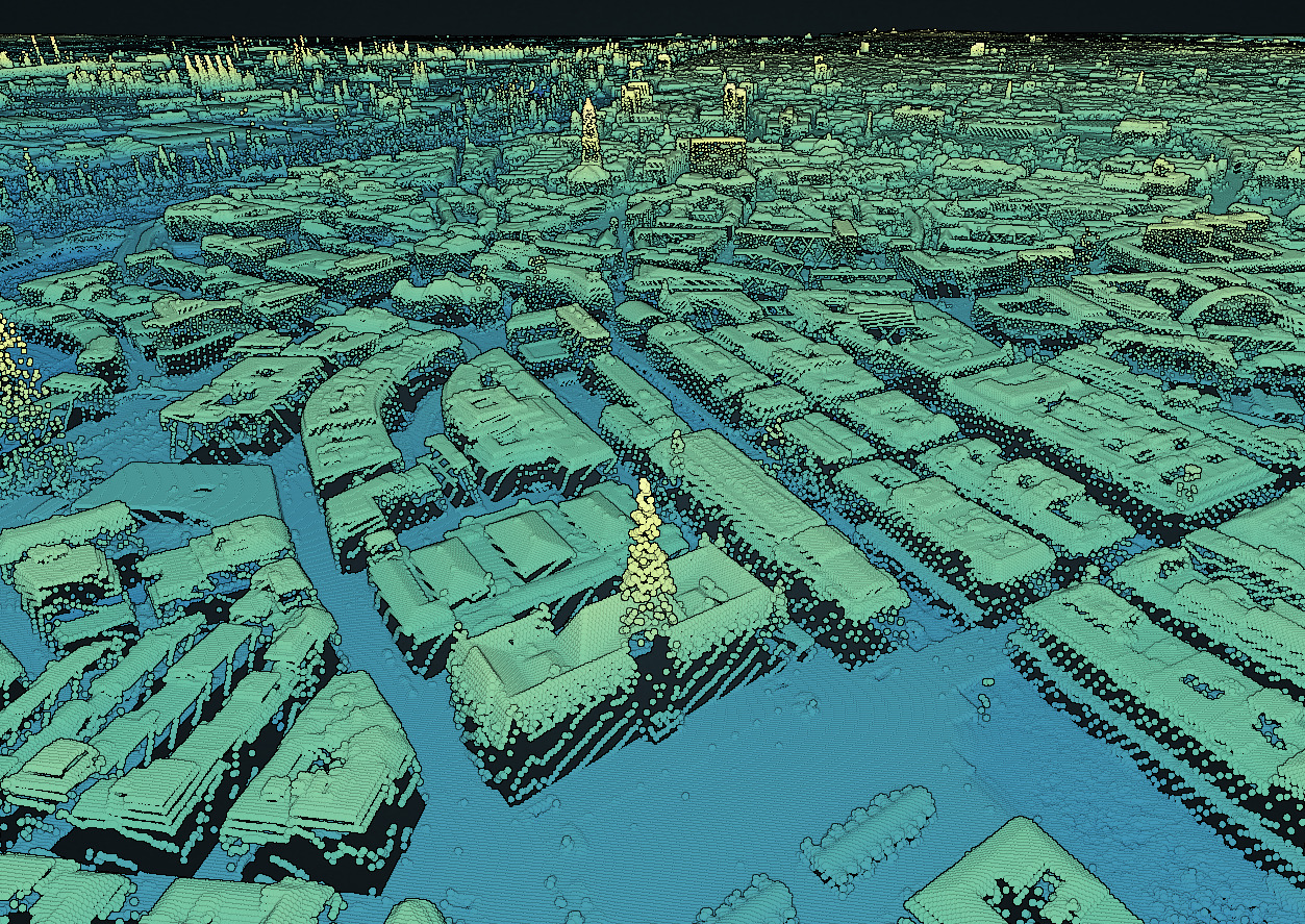
digital elevation model of the city of Hamburg [1] © data: Landesbetrieb Geoinformation und Vermessung | visualization: Hannes
Mapping campaigns
- HailHydrant is now an official MapComplete theme and takes advantage of the browser-based, thematic editor, with the goal of making it easy for anyone to contribute to OpenStreetMap – whether on the desktop or on mobile. This theme focuses on mapping hydrants, fire extinguishers, fire stations, and ambulance stations in your neighbourhood. GOwin, an OSM volunteer from the Philippines, highlights the potential of the tool, and shared how the HailHydrant initiative came about.
Mapping
- The ‘25 Mapathons‘ project team are running a test of a two-part mapathon. The first part was on Wednesday 5 May and the second part will be held on Tuesday 11 May. This test will evaluate a new two-part mapathon concept that is intended to break down existing barriers and challenges for beginners, and to increase user retention, as well as intrinsic and extrinsic motivation.
- A request has been made for comments on the following proposal:
- Libraries_beyond_books_and_multimedia for new types of amenities that expand the word library to cover items other than books and media.
Community
- OpenStreetMap Belgium’s Mapper of the Month for May is Besfort Guri (BesfortGuri) from Kosovo.
OpenStreetMap Foundation
- If you are interested in hosting the 2022 State of the Map conference in your city you can now submit your application. In a mail to OSM-talk Enock Seth Nyamador provided more information about deadlines, procedures and other helpful resources.
Local chapter news
- Donat Robaux has announced
 > , on the talk-fr mail list, that the next annual general meeting of the OpenStreetMap France association will be held online on Saturday 12 June at 2:30 pm. Although all contributors are cordially invited to attend, only members who are up to date with their membership fees will be able to participate in the votes. People who wish to apply for the board of directors must submit their application before 28 May by sending an email to ‘association AT listes.openstreetmap.fr’.
 >
> 
Education
- A flood vulnerability modelling study for Germany has concluded that OpenStreetMap building footprints reduce model prediction errors and increase the reliability of model predictions by a factor of 1.4 in terms of the hit rate when compared to a model that uses only water depth as a predictor. The research comes from the German national institute for the Earth Sciences (GFZ Potsdam) and Humboldt University, Berlin.
- MappingGIS has published > a small guide about OSM and its possibilities.
 >
> Maps
- FacilMap 3 has been released. FacilMap is a browser-based map that aims to combine many different services based on OpenStreetMap into one versatile map, with a focus on planning routes and creating and sharing custom maps where users can add markers, lines and routes with live collaboration. FacilMap 3 is a major rewrite of the software, which includes an improved, smartphone-friendly UI and extensive user documentation.
- Lubin Picard has created a map showing the gender of the people that have a street named after them in Le Mans (France). While it possible to do this through OpenStreetMap data, he choose BD Topo, as it is simpler to use for small projects.
Open Data
- The Landesbetrieb Geoinformation und Vermessung has published > a digital elevation model of the city of Hamburg. Hannes has prepared and visualised > the data and also explains how he did this. Although the grid size is 1 metre, you can see many details.
- The Indian Department of Science and Technology (DST) is inviting comments as part of a consultation on the draft National Geospatial Policy (which we reported on earlier).
 >
> Software
- Heise.de referred, in an article > , to Protomaps, a software package with various tools for web developers for the creation of interactive 2D vector maps based on OpenStreetMap.
Did you know …
- … the (fruit) tree map? If you zoom in more details will be displayed.
- … changelog, which documents developments in the tagging proposal process?
- … the World’s Smallest Map, a complete 3D map of the world, measuring only 22 by 11 micrometres?
- … the website of the OSMF Local Chapters and Communities Working Group (LCCWG)?
- … the YouthMappers Regional Ambassadors, who help the network grow and thrive?
OSM in the media
- The city of Mannheim has been using > HeiGIT’s openrouteservice (ORS) for routing in their publicly accessible online city map. ORS uses OSM data and offers a variety of freely useable API functions with global coverage, as well as different open source libraries and clients.
Other “geo” things
- Steven Kay is well known for interesting visualisations of Edinburgh geodata. This time he has analysed Airbnb reviews, sourced from insideairbnb.com and binned them over a 200 m hexagon grid to show where these apartments are located. The large number of Airbnbs in the city has been a significant political issue for some time.
- Sahana Ghosh reported on mapping future hotspots of carbon dioxide emissions from mangrove loss.
- Over the past six years, Gareth Wild has kept a spreadsheet tracking his use of parking spots at his local supermarket in order to use each one of them. He has described how he ‘conquered’ all 211 of them.
- The Swedish orienteer Tomas Karlsson came across a treasure from the Bronze Age while creating a orienteering map in western Sweden. Whether he used OSM in the process was unfortunately not disclosed in the article.
- Queering the Map is a platform for collaboratively mapping queer experiences. The basemap is, disappointingly, in Google Maps.
Upcoming Events
| Where | What | Online | When | Country |
|---|---|---|---|---|
| Bogotá Distrito Capital | Resolución de Notas de Bogotá | 2021-05-08 |  | |
| 臺北市 | OSM x Wikidata Taipei #28 | 2021-05-10 |  | |
| Zürich | OSM-Treffen Zürich | 2021-05-11 |  | |
| Gárdony | OSM Duma: OSM Tasking Manager repartitioning of Budapest ortophotography, improving on example landing page (online) | 2021-05-11 |  | |
| 20095 | Hamburger Mappertreffen | 2021-05-11 |  | |
| Köln | Stammtisch Köln | ✓ | 2021-05-12 | |
| Chippewa Township | OpenStreetMap Michigan Meetup | ✓ | 2021-05-13 |  |
| Osborne County | OpenStreetMap U.S. Virtual Mappy Hour | ✓ | 2021-05-13 | |
| San Jose | Virtual Civic Hack & Map Night | ✓ | 2021-05-14 | |
| Berlin | 155. Berlin-Brandenburg OpenStreetMap Stammtisch (Online) | 2021-05-13 | | |
| gmina Krośniewice | Virtual meeting of the Polish OSM Association | 2021-05-14 |  | |
| Bogotá Distrito Capital | Resolución de Notas de Bogotá | 2021-05-15 | | |
| Gárdony | OSM Duma: interactive discussion (topic to be determined, online) | 2021-05-17 | | |
| 139. Treffen des OSM-Stammtisches Bonn | 2021-05-18 | |||
| Berlin | OSM-Verkehrswende #23 (Online) | 2021-05-18 | | |
| Lüneburg | Lüneburger Mappertreffen (online) | 2021-05-18 | | |
| Decatur County | Mapping USA | ✓ | 2021-05-20 – 2021-05-22 | |
| Missing Maps DRK Online Mapathon | 2021-05-20 | |||
| gmina Krośniewice | Virtual meeting of the Polish OSM Association | 2021-05-21 | | |
| Bremen | Bremer Mappertreffen (Online) | 2021-05-24 | | |
| Amsterdam | Virtual Meet OpenStreetMap NL | ✓ | 2021-05-25 |  |
| Derby | East Midlands OSM Pub Meet-up : Derby | 2021-05-25 | gb | |
| Gárdony | Monthly Hungarian OSM conference (topics to be determined) | 2021-05-25 | | |
| Ville de Bruxelles – Stad Brussel | Virtual OpenStreetMap Belgium meeting | ✓ | 2021-05-25 |  |
| Düsseldorf | Düsseldorfer OSM-Treffen (online) | 2021-05-26 | | |
| okres Žilina | Missing Maps mapathon Slovakia online #3 | 2021-05-27 |  | |
| [Online] OpenStreetMap Foundation board of Directors – public meeting | 2021-05-28 | |||
| gmina Krośniewice | Virtual meeting of the Polish OSM Association | 2021-05-28 | |
Note:
If you like to see your event here, please put it into the OSM calendar. Only data which is there, will appear in weeklyOSM.
This weeklyOSM was produced by Lejun, Nordpfeil, SK53, Guillaume Rischard (Stereo), SunCobalt, TheSwavu, derFred, renecha.
Die Obstbaumkarte ist evtl. nicht ganz lizenzkompatibel weil die Datenherkunft erst nach Klick auf das “i” angegeben wird, die meisten Besucher da aber gar nicht unbedingt draufklicken werden…