04/05/2016-04/11/2016
Mapping
- Joost Schouppe asks whether airports need a relation.
- BushmanK blogs about the current
natural=waterscheme inconsistency. - Panier Avide presents (automatic translation) iD-indoor, a fork of the iD editor, which is aimed at addressing the needs of indoor mapping.
- Ilya (Zverik) blogs about Maps.me which has recently added the ability to edit OpenStreetMap from within the App. The (Android and iOS) app received a lot of positive feedback.
- The vote on the new relation “Associated Addresses” is open.
- Marco Predicatori is working on a proposal about fake speed cameras.
- Arun writes about vandalism in OSM and discusses possibilities for tracking vandalism.
- The proposal to shop=boat/marine is open. However, there are still issues with the naming.
Community
- Sterling Quinn’s Crowd Lens is a rich viewer of changeset history for OSM in specific areas. Currently five locations are supported.
- Not every reader got the April Fool’s hoax. Though OSM is significant in any case!
- Diana S. Sinton describes in Direction Magazine the overall development and the global movement of OpenStreetMap, mixed with many interesting links.
Imports
- Andrew Davidson starts a discussion on “Refreshing NSW place names from the GNB database”.
- Joe Sapletal asks for support for doing an import of buildings and address data in Dakota, US.
Events
- AGIT 2016 – the Symposium and Expo for Applied Geoinformatics takes place right after the FOSSGIS conference held in Salzburg.
- The fourth OSM Mapathon takes place in Tirana, Albania, at 4PM ( Central European Time ) on the 16th of May 2016
- Manfred published a report about the SwissOSM AGM and the subsequent mapping party in St. Gallen.
- Propose a session to State of the Map US deadline is Monday April 18th.
Humanitarian OSM
- Pete Masters of Médecins Sans Frontières? France explains the practical benefits of humanitarian mapping.
- The NOAH project focuses on prevention and forecast of natural disasters in the Philippines. A report shows the activities of the project in the field of OSM mapping.
Maps
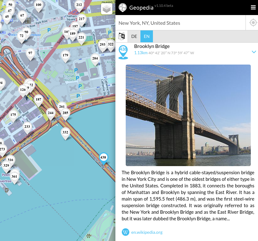
- [1] Michael Schöne has published Geopedia.info. It displays georeferenced Wikipedia articles on an OSM layer, it is available as an Android App. An iOS app is under construction.
- OpenRailwayMap now also supports some railway signals in Finland.
- OpenRouteService published version 3.1 on April 11th. The new features are shown in a video.
Open Data
- Deutsche Bahn has revised (automatic translation) its “Fotoerlaubnis” (photographing permission) has rules on non-commercial photography on railway stations. The new version mentions drones and forbids publication of cab ride videos. The rules are discussed (automatic translation) on a forum of German railway enthusiasts.
Licences
- The Swedish Supreme Court ruled against Wikimedia Sweden this week, deciding that Swedish copyright law does not allow the chapter to post images in its online database without permission from the artist. So, the Swedish map offentligkonst is illegal and the works of art are no longer shown on the map.
Programming
- Zsolt published a beta version of MapHub, which allows users to generate interactive maps very easily. Similar to uMap but has more features in several areas.
Releases
| Software | Version | Release Date | Comment |
|---|---|---|---|
| Mapillary for iOS | 4.2.1 | 2016-04-05 | Changes for GoPro |
| Locus Map Free | 3.16.2 | 2016-04-06 | Bugfix version |
| SQLite | 3.12.1 | 2016-04-08 | 3 bugs fixed |
| Osmose Backend | 1.0-2016-04-09 | 2016-04-09 | – |
provided by the OSM Software Watchlist
Did you know …
- The new Wahoo ELEMNT a GPS Bike computer with OSM maps.
- YouthMappers has local chapters at Universities around the world, and trains young people in mapping OSM.
Other “geo” things
- Amazing interactive 3D map from F4map. More information on free tools to generate 3D maps(in Spanish)
- Flightradar24 discontinued their Google Earth plug-in and developed a replacement 3D view. The new view is built on WebGL using Cesium and Mapbox for amazingly detailed imagery and terrain.
- Heikki Vesanto operates the Scottish site GIS for thought. He writes on many topics including wallets, QGIS applications and the UKRailMap.
- Kenneth Field, a professional cartographer, complains about people doing cartography without a cartographic education it includes a mention of OSM.
- Brian Kilmartin published an interactive world map that summarizes the countries mentioned in the “Panama Papers”.
Upcoming Events
Note: If you like to see your event here, please put it into the calendar. Only data which is there, will appear in weeklyOSM. Please check your event in our public calendar preview and correct it, where appropiate.
This weekly was produced by Hakuch, Laura Barroso, Nakaner, Peda, Rogehm, derFred, escada, jinalfoflia, seumas.
