05.09.–11.09.2023

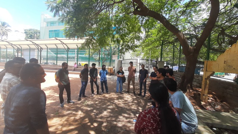
Skupinové mapování zorganizované OSM komunitou v Bengaluru [1] © foto Aman Bagrecha
OSM CZ
- Prosba o pomoc s vytvořením vrstvy OSM pro nevidomé.
- Problém s Fody po upgrade serveru.
- Dají se někde najít aktuální letecké snímky Bachmutu a Avdijivky aneb nemapujte Ukrajinu!
- Blokace mapy.cz jako zdroje dat při mapování přímo v API OSM.
OSM SK
- Jak jsme zmapovali všechny slovenské pralesy.
Mapování
- Black Diamond sdílí svou zkušenost s používáním výškových dat USGS 3D, která jsou dostupná jako podkladová vrstva v editorech iD i JOSM pro většinu území USA pro podporu mapování geografických prvků.
Komunita
- Deus Figendi vyzval své přátele a známé aby je motivoval k detailnímu mapování jejich domů v OpenStreetMap. Pro začátečníky popsal
►
jak na to a doufá, že přiláká nové mappery.
Nadace OpenStreetMap
- Courtney Williamson vydal aktualizovaný program získávání financí pro OpenStreetMap. K 8. září 2023 Nadace OSM obdržela 50 450,85€ od 1 425 dárců. Tyto prostředky budou použity na provoz infrastruktury v datacentru a na zaplacení inženýra, který má na starost její spolehlivost.
- Courtney píše o novém průvodci pro firmy, které používají data OpenStreetMap ve svých produktech a službách. Všichni firemní členové budou mít nyní svého zástupce v poradním sboru Nadace OSM bez dalších poplatků jako kompenzaci za navýšení ročního členského příspěvku pro firmy o 50%.
Události
- [1] Aman Bagrecha sdílí své zkušenosti z účasti na komunitní mapovací akci pořádané komunitou OSM v indickém Bengaluru 9. září 2023.
- Byl zveřejněn finální program pro konferenci State Of The Map 2023 Brazil (2. do 4. října ve městě Curitiba).
Humanitární OSM
- Marocká komunita OSM a Open Mapping Hub – Západní a Severní Afrika v rámci HOT spolupracují na spuštění projektu Marocké zemětřesení pro aktivaci HOT v reakci na tohle neštěstí. Žádají o pomoc mappery a validátory k doplnění dat OpenStreetMap v postižených oblastech a podporu. Mapovací úkoly jsou dostupné na tasks.hotosm.org
Přechod k OSM
- StralsundTourismus.app
►
je nový turistický web pro německé město Stralsund a používá pro své mapy data OpenStreetMap.
Otevřená data
- Miroff publikoval software
►
pro konverzi Státního katalogu geografických jmen Ruska do formátu GeoJSON určeného pro editor JOSM. Poslední verze této datové sady obsahuje 730 738 jmen řek, jezer, hor, vesnic a jiných pojmenování míst. V reakci na to uživatel freeExec připravil aktualizaci seznamu 20 nejdelších nepojmenovaných řek a povodí, kterým je možno v OSM přiřadit jméno pomocí tohoto katalogu a uživatel rtnf nachystal jednoduchého průvodce, jak tento nástroj používat.
- Junior Flores z organizace DevSeed vytvořil
►
interaktivní 3D vizualizační nástroj využívající data OSM, který ukazuje pokrytí mobilním signálem na vzdělávacích institucích v peruánském Ayacucho a také umístění komunikačních antén různých operátorů. Ukázalo se, že z 1 960 institucí v této oblasti má pouze 670 pokrytí mobilním signálem a jen 122 si užívá signál vysoké kvality.
- Daniel O’Donohue z týmu Mapscaping Podcast vyzpovídal výzkumníka z firmy Meta Jenningse Andersona, mluvili o firemním projektu Daylight Map Distribution a Nadaci Overture Maps.
- Raquel Dezidério Souto z brazilské komunity OSM informuje
►
, že mimo jiné věci
►
, získal uživatel Fidelis Assis i data z brazilského sčítání lidu z roku 2022.
Software
- HeiGIT informuje, že jejich nástroj openRouteService (ORS) pro krizové řízení rozšiřuje své pokrytí o Afriku, centrální a jižní Ameriku a jihovýchodní Asii. S využitím dat OSM je QRS aktualizován velmi často, aby bylo zajištěno, že první reakce na katastrofy je schopna navigovat s vědomím infrastruktury, která je zničena nebo zablokována.
Programování
- Projekt osm2pgsql oznámil koncept tématických parků. Ten je možné použít pro vytvoření konfiguračního souboru opakovaným využitím existujících konfiguračních bloků.
- Alexandre Donciu-Julin popisuje, jak použil OpenStreetMap a jazyk Python pro vytvoření mapy ukazující jeho běhání.
Nová vydání
- HeiGIT informují, že nástěnka projektu ohsome byla integrována s taginfo.
- HeiGIT informují o nasazení verze 1.0 jejich API ohsome quality a nástěnky ohsome. Nová verze obsahuje přepracované indikátory aktuálnosti a integraci API ohsome pro kvalitu do nástěnky. Nástroje nabízejí jednoduchý přístup k agregovaným statistikám evoluce elementů OSM od roku 2020.
Věděli jste …
- … o projektu GeoVisio známém také jako Panoramax, což je software pro vlastní server uličních fotografií? Je svobodný a má otevřený zdrojový kód.
- … že strojové učení je použito k vytváření 3D digitálního modelu původního osídlení ze starých map? Tyto modely pak poskytují cenné nástroje pro studium ekonomických ztrát způsobených demolicí historických oblasti.
- … že laboratoře MapTiler nabízejí množství prototypových ukázek práce s daty OpenStreetMap včetně výpočtu výškových profilů, digitálního modelu převýšení, bathymetrické mapy, mapy římského impéria, větrného simulátoru nebo námořních tras?
- … že Pieter Fiers vydal aplikaci pro Android nazvanou OSMfocus Reborn? Je postavená na původním projektu OSMFocus a jejím cílem je pomoci zkoumat detaily tagů pro jednotlivé objekty v OpenStreetMap.
Ostatní geo záležitosti
- Justin O’Beirne recenzuje nový mapový styl map Google.
- Královské námořnictvo testuje kvantovou navigaci. Chtějí ji využít k celosvětovému určení polohy lodi bez spoléhání se na systém GPS.
- literan shromažďuje na svém Telegramovém kanálu
vtipné záběry z uličních fotek.
- Alexey Radchenko analyzoval
veřejná a otevřená data od uživatelů služeb firmy Yandex ohledně silničních nehod v Moskvě a zjistil, že jen 2 % zde nahlášených nehod bylo registrováno i oficiálně.
Plánované události
Poznámka: Pokud zde chcete vidět vaši akci
Návrhy na zajímavé odkazy pro příští čísla nám můžete poslat zde a podělit se tak o ně s našimi čtenáři.
Toto číslo přeložil tom.k a redakčně upravil mkyral. Budeme velmi rádi, pokud podpoříte a oceníte naši práci tím, že budete dílo dále šířit, např. sdílením na sociálních sítích (like, retweet, boost…). Předem za to děkujeme.
Každé číslo v CZ verzi je promováno zde: @osmcz |
  @osmcz |
  Talk-cz |
  osm_sk |
  rss
rss
Můžete nás kontaktovat e-mailem:  weekly@openstreetmap.cz
Originál tohoto souhrnu připravili: MatthiasMatthias, PierZen, Strubbl, TheSwavu, YoViajo, barefootstache, derFred, rtnf.