06/08/2019-12/08/2019
Detailed analysis of OpenStreetMap contributions in North Korea 1 | style © Mapbox – data © OpenstreetMap contributors
Mapping
- A new MapRoulette challenge invites you to check the untouched TIGER roads in the US state of Washington. The import was 12 years ago, and there are still more than 15,000 roads, in this state alone, which have never been checked.
- Eugene Alvin Villar and other members of the OSM Philippines community were pleased to announce an initiative to use AI to help improve the coverage of OpenStreetMap in the Philippines. Tabang-AI is described in more detail on the wiki.
Community
- Did you know that you are contributing to the creation of „a classic question in the digital cartography canon: the case study of OpenStreetMap”? No? Neither did we until we read “Mapping-with”: The Politics of (Counter-)classification in OpenStreetMap. Clancy Wilmott casts an eye, through the lens of critical cartography, over the OpenStreetMap tagging system and concludes that we should add more „ambivalence and fuzziness”.
- The Regional Centre for Mapping of Resources for Development (RCMRD) organised a training program in open-source tools, data and applications. Participants were from the Eswatini Kingdom, Botswana, Namibia, South Africa, Lesotho, Zambia and Zimbabwe. Suchith Anand encouraged others to make use of their teaching and research resources.
- Gunmac reported on their geo teaching session at the Tagores Home Secondary School in India.
- Vincenzo Petito and colleagues published their analysis of the road network in the Italian region of Liguria before and after the collapse of the Morandi Bridge in Genoa. OSM data were used. For performance reasons, the JGraphT library was upgraded for parallel computing.
- With Christian Quest’s rendering of the OSM data in the OSM-France style, you can travel back to the years 2007 to 2011 (one layer per year).
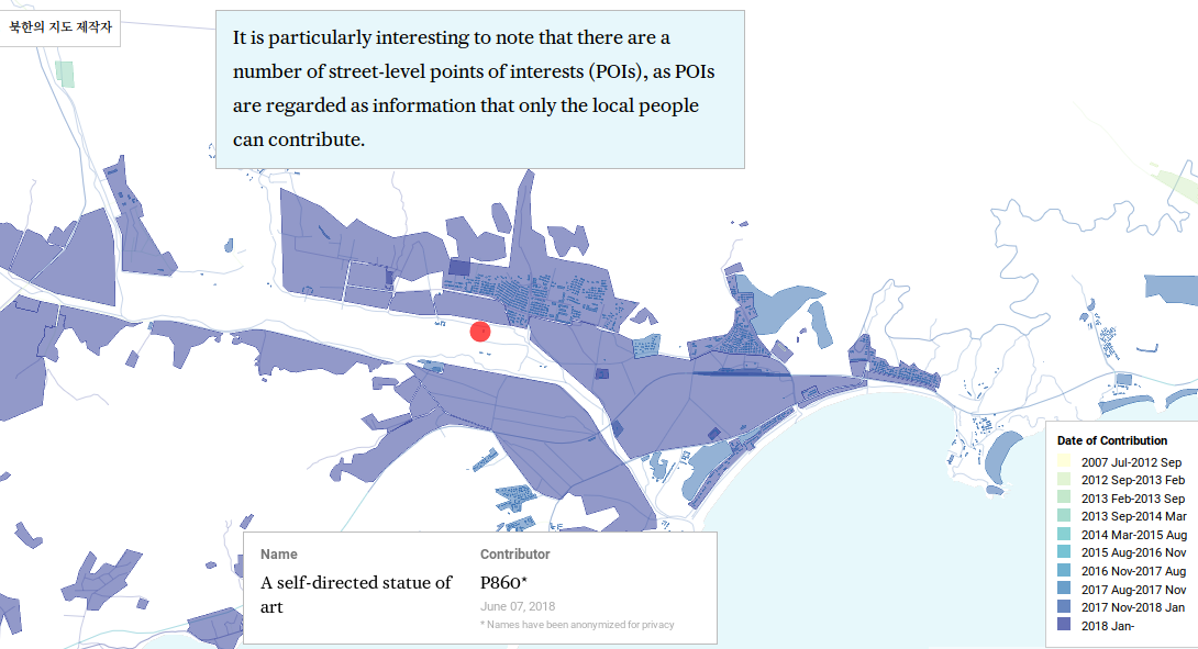
- [1] North Korea is, perhaps, one of the most difficult areas of the world to map. Wonyoung So published a very detailed analysis of OpenStreetMap contributions in North Korea, including a report on mappers’ motivations and mapping strategies.
- What exactly is „volunteered geographic information”? This is the question that Christoph Hormann has been pondering.
- In last week’s Pista ng Mapa conference, two sessions were about AI. First was a lightning talk by Ardie Orden from Thinking Machines and their Map the Gap initiative, and then a mapathon session using Facebook’s MapWithAI RapiD editor and HOTOSM’s Tasking Manager for areas near the host city of Dumaguete. During the conference closing activity, the organisers announced a new initiative to leverage AI-assisted tools for identifying, prioritising, and mapping the road network of the Philippine countryside called Tabang-AI, a Cebuano word for collaboration, or to aid.
OpenStreetMap Foundation
- The OpenStreetMap Foundation has launched a detailed survey about communities, whether on a local or global scale.
Events
- Bennie, from HeiGIT, reports about an OSM workshop run by HeiGIT and GIScience HD at Jena University.
- Last week, the local communities of OpenStreetMap and FOSS4G in the Philippines, concluded their first ever Pista ng Mapa conference in Dumaguete. Local advocate GOwin wrote an OSM diary entry describing the 2019 conference, attended by 166 participants for 2.5 days, by the numbers.
- HeiGIT presented (automatic translation), at the Open Day held at the Federal Foreign Office on 16 and 17 August in Berlin, on the topic of humanitarian aid. Among other things, work in the Missing Maps environment was discussed.
Humanitarian OSM
- The Humanitarian OpenStreetMap Team has released their 2019-2021 strategic plan. HOT aims to work faster, produce higher quality data, and add an area home to one billion people to OpenStreetMap.
- Emmanuel Kourouma blogged about the collaboration between GeoSynapse and Médecins Sans Frontières to run a two-week mapathon session. The mapathon brought together 30 mappers from the GeoSynapse Guinea organisation to digitise the “roads, tracks, paths and rivers” of the Sanguiana Sub-Prefecture and the Kouroussa Prefecture.
switch2OSM
- Christian Nuessli of Schutz & Rettung Zürich (Civil protection of Zurich, Switzerland) announced (automatic translation) on the Swiss mailing list that they have been using OpenStreetMap data in their mission control system for a year now. The civil defence organisation will participate in the collection of data and has — exemplarily — created a wiki page for this purpose and asks about possible wishes of the community and possible cooperation in the collection of data.The thread has other examples of how OSM is used by emergency services elsewhere in Switzerland and Germany.
Open Data
- Transport for London (TfL) have compiled a huge database of cycling infrastructure covering Greater London. They have now released it as open data. Cambridge-based CycleStreets are assessing the quality of the data and its suitability for OpenStreetMap. They should report their findings soon.
Licences
- The Licensing Working Group has consolidated all attribution guidance into one document and it now addresses some of the use cases that have become common over the last seven years. Simon Poole’s announcement on OSM-Talk triggered a discussion on the subject.
Software
- Fabian, from HeiGIT, shows another analytics example using the ohsome API (http://api.ohsome.org/). The analysis was inspired by the global OSM climate protection map.
Programming
- Scientists from the Zentralinstitut für Seelische Gesundheit (ZI), in Mannheim, together with geoinformatics researchers from the University of Heidelberg, and researchers from the Mental mHealth Lab at the Karlsruhe Institute of Technology (KIT), have published research (automatic translation) into the effect of urban green areas on the well-being of city dwellers. Participants were asked to rate their mood several times a day using specially equipped smartphones for a week. Subjects showed a higher level of well-being in situations where they were surrounded by a higher proportion of green spaces in the city.
- Frederik Ramm proposes introducing upload limits in the OSM API. There are two GitHub tickets: one in the Rails port repository (now closed), and one in the Cgimap repository.
- Routing optimisation generally solves the Vehicle Routing Problem (a simple example being the more widely known Travelling Salesman Problem). A more complex example would be the distribution of goods by a fleet of multiple vehicles to dozens of locations, where each vehicle has a certain time window in which it can operate and each delivery location has certain time windows in which it can be served (e.g. opening times of a supermarket).In a new Jupyter notebook example HeiGIT looks at a typical humanitarian scenario of distributing medical goods during disaster response following one of the worst tropical cyclones in Africa using OpenRouteService and VROOM.
- Paul Kernfeld explains some of the clever performance tricks which make OSM data stored in the popular .osm.pbf file format much more compact than XML.
Releases
- The OSM based offline map app Maps.Me supports Apple CarPlay in the latest update. With it you can interact with the app via the car, if it has CarPlay integrated, or display the route on the infotainment system.
- StreetComplete v13.0 added some new quests and enhanced others.
Did you know …
- … about the 7 Top Free Satellite Imagery Sources in 2019?
- … of the list of CartoCSS projects you can use to style data in Tilemill?
- … about the list of organised editing activities?
- … about the CIA’s role in the development of Google Earth?
Other “geo” things
- OpenStreetMap Slovenia directed our attention to the largest known printed OpenStreetMap (automatic translation) of Ljubljana, produced by local company Tam-Tam to direct people around a culture walk of the capital. Unfortunately the posters do not carry the appropriate attribution.
- Mapbox announced the opening of their operations in Japan. Working with their partner in Japan, Zenrin, they are creating new maps for Yahoo! JAPAN.
- Matt Brown spent a month using Minecraft Earth around the streets of London and reported where Microsoft is headed with the platform.
- New Zealand, having lost (on a technicality…again) the title of world’s steepest street to Wales, is not taking it lying down. Plans to reclaim the title include: pouring concrete down Baldwin Street in the style of The Englishman Who Went Up A Hill But Came Down A Mountain, sealing a section of existing unformed legal road, or failing that, a trip to Wales with shovels.
- Sebastian Grüner describes (automatic translation) the perils of relying on automatic data analysis in map making. Countless skyscrapers in the Saxon Switzerland National Park, suggestions to travel over historic routes that are now officially closed for nature conservation reasons, or instructions to drive up steps are just some of the results you can enjoy.
- DC Rainmaker has updated his guide to adding free maps to your Garmin Edge Series device. The process is much easier now thanks to Garmin.OpenStreetMap.nl.
- The European Space Agency has sponsored the development of Urban TEP, the first map that combines optical and radar satellites to create a human urban footprint map of the world. The initial map was created using 2014-2015 data from the Copernicus Sentinel-1 radar-based satellite and Landsat-8 multi-spectral satellite images. Mark Altaweel explains the uses to which this data could be applied.
- So you think you’re a dedicated mapper? Give us a call back when you can beat the Cassini Family. Jay Foreman and Mark Cooper-Jones present a short video on the history of the world’s first accurate map: the Carte de Cassini.
- University of Massachusetts at the Amherst campus have built a software tool, called DeepRoof, which they say has achieved an accuracy of 91% in identifying a roof’s solar power potential, by using widely available (and cheap) satellite data from tools like Google Earth.
Upcoming Events
| Where | What | When | Country |
|---|---|---|---|
| Osaka | みんなで東淀川区の魅力を発信しよう! | 2019-08-18 |  |
| Melbourne | Indigenous name mapathon | 2019-08-20 |  |
| Cologne Bonn Airport | Bonner Stammtisch | 2019-08-20 |  |
| Lüneburg | Lüneburger Mappertreffen | 2019-08-20 | |
| Lübeck | Lübecker Mappertreffen | 2019-08-22 | |
| Kameoka | 京都!街歩き!マッピングパーティ:第11回 出雲大神宮 | 2019-08-24 | |
| Bremen | Bremer Mappertreffen | 2019-08-26 | |
| Salt Lake City | SLC Map Night | 2019-08-27 |  |
| Viersen | OSM Stammtisch Viersen | 2019-08-27 | |
| Düsseldorf | Stammtisch | 2019-08-28 | |
| Dortmund | Mappertreffen | 2019-08-30 | |
| Galway | Galway mapping party | 2019-08-31 |  |
| Maebashi | オープンストリートマップセミナーとマッピングパーティ | 2019-09-01 | |
| London | Missing Maps Mapathon London | 2019-09-03 |  |
| Stuttgart | Stuttgarter Stammtisch | 2019-09-04 | |
| Bochum | Mappertreffen | 2019-09-05 | |
| Dresden | Stammtisch Dresden | 2019-09-05 | |
| Montrouge | Rencontre des contributeurs de Montrouge et alentours | 2019-09-05 |  |
| Minneapolis | State of the Map U.S. 2019 [1] | 2019-09-06-2019-09-08 | |
| Edinburgh | FOSS4GUK 2019 | 2019-09-18-2019-09-21 | |
| Heidelberg | Erasmus+ EuYoutH OSM Meeting | 2019-09-18-2019-09-23 | |
| Heidelberg | HOT Summit 2019 | 2019-09-19-2019-09-20 | |
| Heidelberg | State of the Map 2019 [2] | 2019-09-21-2019-09-23 | |
| Dhaka | State of the Map Asia 2019 | 2019-11-01-2019-11-02 |  |
| Wellington | FOSS4G SotM Oceania 2019 | 2019-11-12-2019-11-15 |  |
| Grand-Bassam | State of the Map Africa 2019 | 2019-11-22-2019-11-24 |  |
Note: If you like to see your event here, please put it into the calendar. Only data which is there, will appear in weeklyOSM. Please check your event in our public calendar preview and correct it, where appropriate.
This weeklyOSM was produced by GOwin, Nakaner, Polyglot, Rogehm, SK53, TheSwavu, YoViajo, derFred, keithonearth.