17/09/2019-23/09/2019
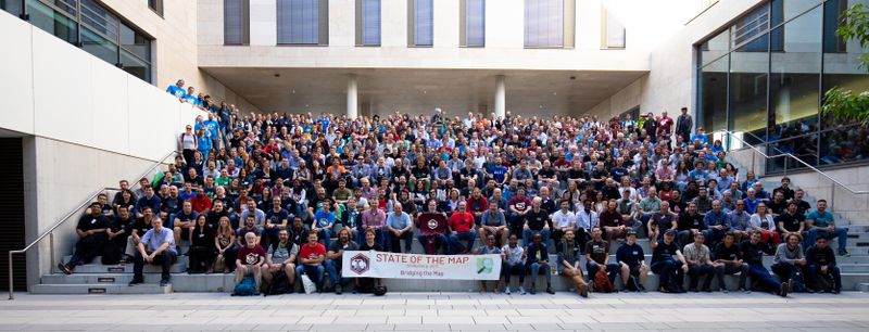
SotM 2019 in Heidelberg, Germany 1 | Photo © Thomersch CCBYSA2
SotM 2019
- The latest international State of the Map conference came to a close in Heidelberg, a city in Southwest Germany. A tweet shares a group picture of around 600 participants who came from all over the world.
- Some weeklyOSM editors met (automatic translation) at SotM 2019, in Heidelberg, Germany. It was great to finally see the faces behind the nicknames.
- „OpenStreetMap, a silent and useful digital revolution” a press release about the SotM, HOT and OSM in general by GIScienceHD, Heidelberg.
- The Maptiler company has published a blog post where they highlight the most important things, from their point of view, about SotM 2019.
- The „Chaos Computer Club” (CCC) published all the videos they recorded at SotM 2019.
- The State of the Map conference recently concluded in Heidelberg, Germany, and two participants of the scholars program share their experience: Polyglot from Belgium and Anditabinas from the Philippines.
Mapping
- Warin announced the start of voting for horse mounting blocks. The format of voting is different from usual. Not only can one vote for or against the proposal, but also there is a choice to vote for the key name (i.e. man_made, leisure, horse, bridleway, animal or amenity) as well.
- The Bing Maps team contributed building footprint datasets for Uganda and Tanzania to OpenStreetMap.
- The proposal for campsite properties, which aimed to allow enhanced mapping of camping areas, failed to achieve the necessary support.
- The tag
cash_withdrawal=*, intended to tag the possibility of withdrawing cash in a shop or amenity, has been unanimously accepted. The only vote against came after the end of the voting period. - The Christian Martinus community has included the subway in Vienna as part of a pilgrimage route, which led to some discussion (automatic translation) and double checks after the route relation was entered in OSM.
Community
- The winners of the OSM Awards 2019 have been announced. We join in the congratulations and say thank you to all nominees, whether winners or not.The winners were:
- Core systems: Andy Allan
- Innovation: Adrien Pavie
- Influential Writing: Steve Friedl, Guillaume Rischard
- Mapper of the Year: Alan Mustard
- Community Building: Nathalie Sidibé
- Team: Data Working Group
- Ulf Miller: Victor Shcherb
- Marco Minghini and Francesco Frasinelli, of the European Research Centre, have published a paper with the title OpenStreetMap history for intrinsic quality assessment: Is OSM up-to-date?
- OpenStreetMap Foundation Colombia created a game methodology (automatic translation) to teach different people the use of OSM in different contexts. The main idea is to solve the challenge of bringing new technologies to places where people have low levels of technological adoption.
- Jennings Anderson provided a compilation of data visualisations showing the impact of individual mappers on the development of OSM.
Imports
- CycleStreets has been looking at TfL’s (Transport for London) massive new cycling dataset, and proposed 11 new tags which would allow useful attributes, which are not currently supported, to be represented in OSM. Comments on the proposals are welcomed. All the new tags are compatible with existing OSM data and generally enhance existing information to improve routing.
Events
- Maptime in Boston has announced their next event is on 2 October 2019. Maptime in Boston will be hosted in Facebook’s Boston office.
- The 19th „Schemotechnica” will be held (automatic translation) in Moscow (Russia) on 10 October. It’s a mini-conference on OSM and open GIS. Do not forget to register!
 (automatic translation)
 (automatic
Humanitarian OSM
- HOT is looking for a new director of technology.
- Médecins Sans Frontières (MSF) conducted a measles vaccination campaign in Chad using only hand drawn maps until Missing Maps volunteers helped create digital maps.
- Yer Çizenler started a mapping campaign for the Denizli Earthquake.
- Third Sector, a UK-based publication for the voluntary and not-for-profit sector, published an article titled How charities can benefit from the power of micro-volunteering about OpenStreetMap and other citizen science projects and how organisations can make use of it.
- HOT announced improvements to MapCampaigner, a tool for managing and monitoring field data collection. The plan is to „…progress [the] tracking and quality monitoring tool to [become] an end-to-end mapping campaign management platform”.
- Aimée Sama of the OSM community in Togo has created a project to map urban heat islands. An urban heat island is an urban or metropolitan area that is significantly warmer than the surrounding rural areas due to human activity. The temperature difference is usually greater at night than during the day, and is more noticeable when the wind is weak. The project aims to map trees and green spaces to help reduce this problem.
Education
- Applications are invited for the 2020 YouthMappers Research Fellowship and will be accepted until 1 November 2019. Students who apply must be associated with a YouthMappers chapter in good standing.
Releases
- Sven Geggus has updated the Opencampingmap. Amongst other features you can now find
amenity=power_supplyon campsites. - Joseph Eisenberg wrote a blog post about the update of OSM’s map style Carto to version v4.23.0. The new version restores labels on specific nodes such as
leisure=sports_centre, fixed a bug that duplicated the parking icon, brightened aerodrome rendering and much more. - We’d like to point to wambachers OSM software watchlist, which lists the current version of software with relevance in the OSM universe. You can also follow #OSMSoftwareWatchlist on Twitter to get information on which software has received an update.
Did you know …
- … of all the new aerial imagery that is available for OSM in Croatia? The Croatian State Geodetic Administration changed (automatic translation) their Geoportal terms of use to allow derivative works, so the aerial imagery and topographic maps can now be used for OSM. In addition, the cities of Knin (automatic translation) and Zagreb (automatic translation) have granted the use of their aerial imagery from 2007 and 2012 for use in OSM. Zagreb also provides (automatic translation) imagery with a resolution of 20 cm. Data has been processed and is served as a TMS layer on the OSM Croatia server.
Other “geo” things
- Alasdair Rae tweeted a link to his slides from his presentation at FOSS4GUK: From map projections to geogifs to mapping – My journey through open source GIS.
- If you love old maps you may want to join the „Royal Society for the Preservation of Boring Grid Squares„. Tim Waters points out this interesting organisation, which is committed to saving „boring” grid squares in the Landranger map series of the Ordnance Survey. Harry Wood noted that the organisation has important work to do in Scotland as OSM mappers are filling in the blanks leaving precious few boring tiles.
- „streetfightmag.com” lists five privacy focused map apps with a brief description of each in a short article.
- An article has been published (translation) on „moment.at” that shows a world map of CO2 emissions per capita for each country. The article also looks at „CO2 emission outsourcing”, e.g. where the goods are bought in Austria, but the CO2 emissions are assigned to the producing country, China.
- The Irish Times explains why Ireland needs better land cover information. Ireland is one of the few remaining countries in Europe which do not have detailed land cover information. The only available dataset, some parts of which have also found their way into OSM, is the EU’s Corine (Co-ordinated Information on the Environment) dataset, which is not very detailed – it does not include areas smaller than 25 hectares.
- The Federal Ministry of Transport in Germany opened (translation) a road for testing autonomous vehicles. These vehicles will share the road with regular traffic in the 3.6 kilometres between the Brandenburg Gate and Ernst-Reuter-Platz.
- The publication Geospatial World features an article about BGT, a public registry of geospatial data that serves as a national digital topographic map for the Netherlands. The building of such a registry has required the coordination of institutions working at many different levels.
Upcoming Events
| Where | What | When | Country |
|---|---|---|---|
| Nagoya | 第2回まちマップ道場-伊勢湾台風被災地を訪ねる- | 2019-09-28 |  |
| Strasbourg | Rencontre périodique de Strasbourg | 2019-09-28 |  |
| Kameoka | 京都!街歩き!マッピングパーティ:第12回 穴太寺(あなおじ) | 2019-09-29 | |
| Mainz | Stammtisch | 2019-09-30 |  |
| Rome | Incontro mensile | 2019-09-30 |  |
| London | London Missing Maps Mapathon | 2019-10-01 |  |
| Stuttgart | Stuttgarter Stammtisch | 2019-10-02 | |
| Brno | State of the Map CZ+SK 2019 | 2019-10-02-2019-10-03 |  |
| Bochum | Mappertreffen | 2019-10-03 | |
| Montrouge | Rencontre mensuelle des contributeurs de Montrouge et alentours | 2019-10-03 | |
| Fujisawa | 湘南マッピングパーティ | 2019-10-05 | |
| Kinshasa | Rencontre OSM Kinshasa | 2019-10-05 |  |
| Ballaghadereen | Map Ballaghadereen | 2019-10-05 |  |
| Budapest | OSM Hungary Meetup reboot | 2019-10-07 |  |
| Lyon | Rencontre mensuelle pour tous | 2019-10-08 | |
| Munich | Münchner Stammtisch | 2019-10-08 | |
| Salt Lake City | SLC Mappy Hour | 2019-10-08 |  |
| Hamburg | Hamburger Mappertreffen | 2019-10-08 | |
| Cologne | Köln Stammtisch | 2019-10-09 | |
| Arlon | Espace public numérique d’Arlon – Formation Consulter OpenStreetMap | 2019-10-09 |  |
| San José | Civic Hack & Map Night | 2019-10-10 | |
| Nantes | Réunion mensuelle | 2019-10-10 | |
| Berlin | 136. Berlin-Brandenburg Stammtisch | 2019-10-11 | |
| Berlin | Berlin Hack Weekend Oktober 2019 | 2019-10-12-2019-10-13 | |
| Greater Manchester | Joy Diversion 8 | 2019-10-12 | |
| Santa Fe | State of the Map Argentina 2019 | 2019-10-12 |  |
| Bordeaux | Réunion mensuelle | 2019-10-14 | |
| Taipei | OSM x Wikidata #9 | 2019-10-14 |  |
| Cologne Bonn Airport | Bonner Stammtisch | 2019-10-15 | |
| Lüneburg | Lüneburger Mappertreffen | 2019-10-15 | |
| Arlon | Espace public numérique d’Arlon – Formation Contribuer à OpenStreetMap | 2019-10-16 | |
| Berlin | Missing Maps Mapathon – Putting the Wolds’s Vulnerable People on the Map | 2019-10-17 | |
| Karlsruhe | Karlsruhe Hack Weekend | 2019-10-19-2019-10-20 | |
| Prizren | State of the Map Southeast Europe | 2019-10-25-2019-10-27 |  |
| Dhaka | State of the Map Asia 2019 | 2019-11-01-2019-11-02 |  |
| Wellington | FOSS4G SotM Oceania 2019 | 2019-11-12-2019-11-15 |  |
| Grand-Bassam | State of the Map Africa 2019 | 2019-11-22-2019-11-24 |  |
| Cape Town | State of the Map 2020 | 2020-07-03-2020-07-05 |  |
Note: If you like to see your event here, please put it into the calendar. Only data which is there, will appear in weeklyOSM. Please check your event in our public calendar preview and correct it, where appropriate.
This weeklyOSM was produced by Elizabete, Kleper, Nakaner, NunoMASAzevedo, Polyglot, Rogehm, SK53, SeverinGeo, SomeoneElse, SunCobalt, TheSwavu, YoViajo, derFred, doktorpixel14, geologist, anonymus.