2024/05/30-2024/06/05

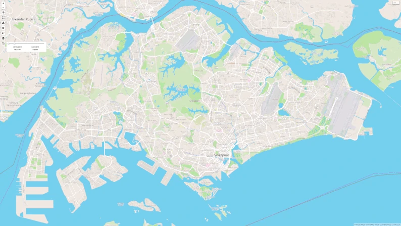
ジェローム・リモザンは、シンガポールのすべての道路の99%を自転車で通り抜けることができました [1] |© wandrer.earth |地図データ © OpenStreetMap貢献者
マッピング
- [1] シンガポールを拠点とするOpenStreetMapのマッパーであるJérôme Limozin氏は、Wandrer探索ゲームを使って、シンガポールの全道路の99%を自転車で通過することに成功しました。
- OpenStreetMapのZverikとIlya Zverevは、2024年6月1日をもって、Level0テキストエディタとOSM画像ブラウザやオフセットデータベースフロントエンドなどの他のサービスが一時的に機能しなくなると発表しました。Ilya は、Every Door の開発により、OAuth 2 への移行に間に合うようにサービスを新しいサーバーに移行できなかったと説明しています。この混乱は、緊急のコミットメントがない限り、1か月間続くと予想されています。
マッピングキャンペーン
- IrdiIsはアルバニアの農村マッピングを推し進めることを決定し、今後100日間で100の村をランダムに選んでマッピングします。
- OpenStreetMap Indiaは、2024年6月1日にOpenStreetMapバンガロールコミュニティが開催したSahakarnagar Mapping Partyイベントで、主にSahakarnagar Park周辺のベンチ、ガゼボ、街灯で構成される250以上の地物のマッピングに成功したと報告しました。
OpenStreetMap Foundation
- OSM CWGがOSMの20周年記念パーティーの画像収集をすすめていて、お気に入りの写真や過去20年間のOpenStreetMapの画像を募集しています。
地方支部ニュース
- FOSSGISは、連邦デジタル運輸省から送られたモビリティデータ法の草案に関する公式声明を発表しました。彼らは、この法案が欧州連合内のOpenStreetMapプロジェクトに悪影響を与える可能性があると主張しています。FOSSGISは、OSMプロジェクトに対する即時データ更新要件の免除や、ユーザから報告されたデータエラーに対処する義務など、いくつかの改訂を提案しています。
イベント
- Gislarsは、2024年11月2日から3日にかけて、ベルリンのウィキメディア・ドイツで OpenStreetMap Berlin Hack Weekend を開催すると発表しました。
- スイスOpenStreetMap協会は、観光の専門家や開発者向けに無料ウェビナー OpenStreetMap für den Tourismus を開催しています。参加者は、観光サービス改善にむけて、POIの効果的な活用方法を学びます。ウェビナーは2024年6月19日と25日に開催され、BigBlueButtonから登録なしでアクセスできます。
教育
- Raquel Dezidério Souto 博士 (IVIDES) が FastDrawプラグインを利用したJOSMの水路マッピングガイドを公開
>
しました。この取り組みは、ブラジルのリオグランデ・ド・スル州で現在進行中の災害の影響を受けた主要地域の1つであるタクアリ・アンタス川流域のマッピングプロジェクトの一環です。キャンペーンのwikiページには様々なマッピング計画が記載されており、OpenStreetMapマッパーのグローバルコミュニティの協力が求められています。
OSM research
- Benjamin Herfortらは、「北極圏の工業地帯における OpenStreetMap のデータ品質」と題する研究を発表しました。
- HeiGITの報告によると、同社のopenrouteサービスは、ドイツ全土の医療、教育、その他の施設の到達可能性分析を作成することを目的としたプロジェクトであるEU-Project Grid Cell Databaseで使用されています。
地図
- Candid Dauth は、OpenPublicTransportMap を復活させ、FacilMap の追加マップ スタイルとして利用できるようにするために、より大きなサーバーに投資することを決定しました。さらに、財政的支援を探しています。
OSM in action
- Rihard Olupsさんは、ラトビアにあるEU議会選挙の投票所の場所を示すインタラクティブマップを共有しました。
- User_5359 さんは、シレジア文化研究所財団 (Stiftung Kulturwerk Schlesien) が管理する歴史的保存物の場所を示す OpenStreetMap ベースのインタラクティブマップを開発しました。絵葉書、サイン、切手、古地図、古証券、作家作品、戦見図書、誓願書など、さまざまなコレクションがあります。
ソフトウェア
- Michael Mannは、OpenStreetMap のコントリビューターのリーダーボードを、特定のバウンディングボックスと期間にコントリビュートしたノードの数に基づいて表示するdashベースのダッシュボードである OSM_LeaderBoard を開発しました。
プログラミング
- Volker Krause さんは、旅行アシスタント KDE Itinerary アプリケーションの最近の更新を報告しました。
- NorthCrabは、OpenStreetMapコードベースの個人的な代替案である OpenStreetMap NextGen Development に関する9番目のブログをリリースし、MacOS開発環境のサポート、変更セット履歴インターフェイスの更新、新しいGPSトレースアニメーション機能などのいくつかの更新を報告しています。
- PeachyOneは、ギリシャ語圏のアクセントの間違いを修正するためのoverpassクエリを共有しています。
- SomeoneElse は、Shortbread、Tilemaker、VersaTiles でタイルサーバーを設定する方法を説明しています。
リリース
- Tobias Zwick は、さまざまな新しいクエストと多数の機能強化を特徴とする StreetComplete バージョン 58.0 をリリースしました。
ご存知でしたか?
- …bxl-foreverはOpenStreetMapの初心者コントリビューターのためのガイドブックをまとめています。
- …Inforoute Franceのプラットフォームを使用して、フランスの道路状況の現在の状態を監視できます。
- …UIパターンMapマップ付きのプログラムや Web サイトで使用される UI 要素とパターンの詳細な概要と説明です。この Web サイトの作成者は、これらの要素を正しく使用することで、デジタル マップの使いやすさとユーザー エクスペリエンスを向上させ、一般的なエラーを回避する方法のヒントと例を示しています。
- …Shade Mapアプリを使用して、建物、山、木の背後にある影の動きをシミュレートできます。
メディア掲載
- Zdnet.frは6月末に3日間リヨンで開催されたSOTM-FRと、IGNとOSM Franceが提携する「Panoramax」プロジェクトの成長について、OpenStreetMapコミュニティミーティングの様子を説明しています
>
。
- Ouest Franceは、OpenStreetMapデータベースを使用して、D-Dayに関連するフランスの道路名を分析しました。彼らは、D-Dayに直接関連する90の道路を特定し、その大半はノルマンディーに集中していました。
- 山陽新聞デジタルは、Ray FrontierがSilentLogアプリユーザーの移動行動パターンを分析したと報じています。この匿名化された旅行データは、OpenStreetMapのPOIデータと直接比較され、ユーザーが訪れた場所の種類を調べました。
その他の “ジオ” な事柄
- GIS企業Mieruneは、2024年6月から8月にかけて、初級、中級、上級レベルの定期的なQGISトレーニングを開催します。
- FreethinkとSkoll Foundationは、OpenStreetMapとHOTがソフトウェアと地域ハブを通じて、人道的災害、気候変動、都市問題などの課題に対応するために世界中のコミュニティをどのようにサポートできるかを説明するドキュメンタリービデオを公開しました。
まもなく開催
| 場所 | イベント名 | オンライン | 開始日 | 国 |
|---|---|---|---|---|
| コーベンハウン | OSMmapperCPH | 2024-06-09 | ||
| ロンドン・ハックニー区 | London Ruby User Group talk on OSM | 2024-06-10 | ||
| グルノーブル | Atelier du groupe local OpenStreetMap | 2024-06-10 | ||
| ツーク | 164. OSM-Stammtisch ausnahmsweise in Zug | 2024-06-11 | ||
| サンノゼ | サウスベイ・マップナイト | ✓ | 2024-06-12 | |
| ソルトレイクシティ | OSM Utah Monthly Map Night | 2024-06-13 | ||
| ロレーン郡 | OpenStreetMap Midwest Meetup | ✓ | 2024-06-13 | |
| ブリュッセル | OSM Belgium meetup in Brussels | 2024-06-13 | ||
| ボーフム | Bochumer OSM Treffen | 2024-06-13 | ||
| ミュンヘン | Münchner OSM-Treffen | 2024-06-13 | ||
| ベルリン | 192. ベルリン・ブランデンブルク OpenStreetMap Stammtisch : osmcalpic: | 2024-06-14 | ||
| ディフェンス コロニー テシル | 9th OSM Delhi (Indoor) Mapping Party – Session 1 | 2024-06-15 | ||
| Kalkaji Tehsil | 9th OSM Delhi (Indoor) Mapping Party – Session 2 | 2024-06-16 | ||
| ハノーバー | OSM-Stammtisch Hannover | 2024-06-16 | ||
| England | OSM UK オンラインチャット | 2024-06-17 | ||
| リヨン | Réunion du groupe local de Lyon | 2024-06-18 | ||
| ボン | 176. OSM-Stammtisch Bonn (Juni 2024: 20 Jahre OSM – 15 Jahre Stammtisch Bonn) | 2024-06-18 | ||
| エディンバラ市 | OSM Edinburgh pub meetup | 2024-06-18 | ||
| ユトレヒト | OSGeo.nl Open Zomerpodium – OSGeo.nl Open Summer Stage | 2024-06-19 | ||
| カールスルーエ | Stammtisch Karlsruhe | 2024-06-19 | ||
| シュタイナッハ・ピュルグ | 13. Österreichischer OSM-Stammtisch (online) | 2024-06-19 | ||
| OSM-Deutschland Vernetzungstreffen | 2024-06-20 | |||
| OSMF エンジニアリングWG会議 | 2024-06-21 |
‘
Note: ここであなたのイベントを見たい場合は、カレンダーにそれを OSM Kalender 入れてください。そこにあるデータのみが、週刊 OSM に表示されます。 カレンダー 内で都市や国に言及するのを忘れないでください。
This weeklyOSM was produced by Aphaia_JP, MatthiasMatthias, Raquel Dezidério Souto, Strubbl, derFred, euroPathfinder, mcliquid, miurahr, muramototomoya, rtnf.