01/02/2022-07/02/2022

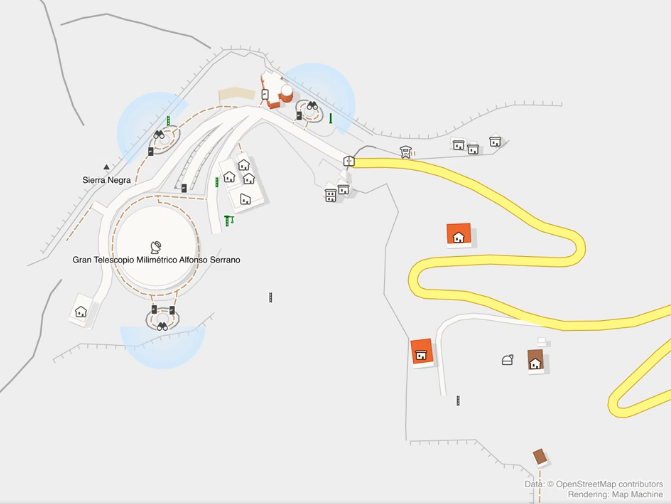
Sergey Vartanov’s Renderer [1] | © map-machine © OpenStreetMap contributors
Mapping campaigns
- Cristoffs showed
>
some statistics on the progress of mapping defibrillators (AED) in Poland.
Mapping
- Marjan, from TomTom, has initiated a MapRoulette challenge to add missing roads in the Caribbean.
- Florian Lohoff is puzzled about a strange behaviour of the OSRM routing engine that he uses to monitor the road network in OSM.
- Jherome Miguel, from Alberta, Canada, proposed developing and documenting a new highway classification scheme covering trunk roads and motorways, based on one being implemented in the USA. In Quebec, thousand of kilometres to the east, mappers are satisfied with the road classification as it is. Pierre Béland, author of Highway Tag Africa, suggested documenting
>
the classification of the forestry roads, sometimes hundred of kilometres long, managed by the forestry industry. On unpaved roads, heavy trucks have priority over other vehicles that access things in these areas such as chalets, fishing, or hunting.
- Gruff Owen started a discussion on Talk-GB about the mapping and tagging of what he called a ‘goat track’ in OpenStreetMap, which is a potentially dangerous path, and there are concerns that this could lead inexperienced walkers into dangerous situations.
- After complaints, Vespucci is removing Bing aerial imagery for third-party builds, e.g. F-Droid.
Community
- YouthMappers is inviting
>
people to a one-hour information session at 14:00 Friday 18 or 15:00 Saturday 19 February (Guatemalan time). The event is for students from Guatemala and anyone interested in starting new YouthMappers groups in Latin America.
- On Mastodon, MapAmore summed up the result of phase two of the OSMaPaaralan school mapping project in the Philippines.
- OpenStreetMap Belgium’s Mapper of the Month for February is Mustafa Kamil from Sudan.
- User contrapunctus proposed a mapping event in Delhi, and got quite a bit of interest.
- User Ziegenfritze wondered
>
how to best plan where to walk with his goats from Überlingen to Meißen, 583 km from Southwest to East Germany, using OpenStreetMap.
Imports
- Sofia Kozidis announced a proposed import in Bayfield County (Wisconsin, USA) of Emergency Location Markers.
Local chapter news
- The OSM-US February Newsletter has been published here.
Events
- HeiGIT, the Heidelberg Institute of Geoinformation Technology, is presenting
a lecture on ‘ohsome quality analyst (OQT): assessing the quality of OpenStreetMap data’ at the FOSSGIS conference
>
on Wednesday 9 March from 16:30 to 16:50 CET.
Maps
- Enzet has mapped the ‘Large Millimetre Telescope’ in Mexico in great detail. He created a ‘before and after’ animation in colour and with roof slopes with his Map Machine software.
- @RandoCarto
published a new hiking map. This time, you can go and hike in the volcanoes of the Puys de Dôme, France with a printed paper map made from OSM data.
Open Data
- Pascal Neis has written a blog post comparing
>
German Federal Government and OSM data for
amenity=policeandgovernment=healthcarein Germany (the Government data was from the Federal Agency for Cartography and Geodesy). He concluded that ‘at least in Germany’ … ‘no more data imports should take place’. Data reconciliation is, in his opinion, a promising way to improve data quality on both sides. Tobias suggested>
possibilities for realising this idea.
Programming
- Nicolas Lambert has published bertin.js, an easy to use D3.js-wrapper on GitHub, that can be used to create thematic maps.
- A change to API 0.6 will be deployed in the near future. After the change the OSM API will reject relations exceeding a certain number of relation members (significantly more than used in any current relation). The reason for the change is that extremely large relations can cause problems to downstream data consumers. The largest current relation is Tongass National Forest, which is already too large to be visible on the OSM website’s ‘relation view’.
Releases
- Kontur posted a Twitter thread which featured a new version of Disaster Ninja – a tool for mapping coordination and spatial analytics. It is now possible to get OpenStreetMap analytics within administrative boundaries or freehand polygons to know where to put your mapping efforts.
- The iD editor was recently updated from 2.20.2 to 2.20.4, including various improvements such as security fixes, improvements to screen reader accessibility, enhanced preservation of the history of OSM objects, bugfixes and more. See the changelog for the full list of changes. This version of iD will be the last to support Internet Explorer 11.
- Richard has released a new version of the Potlatch 3 OSM editor, which contains several fixes. Once running it can be invoked from OSM by remote control, just like JOSM can.
Did you know …
- … the map farmshops.eu
, a ‘Code for Karlsruhe’ project? You can find farm shops, markets, milk vending machines and other direct marketers between Brussels and Brno. The data comes from OSM, of course.
- … the true size of a country? After selecting a country you can move it with the mouse on a world map (Google Maps, unfortunately) in Mercator projection and it changes the displayed size according to where it is placed.
Upcoming Events
Note:
If you like to see your event here, please put it into the OSM calendar. Only data which is there, will appear in weeklyOSM.
This weeklyOSM was produced by Nordpfeil, PierZen, RicoElectrico, Sammyhawkrad, SomeoneElse, Strubbl, TheSwavu, conradoos, derFred.
>… the true size of a country? After selecting a country you can move it with the mouse on a world map (Google Maps, unfortunately)
https://addons.mozilla.org/ru/firefox/addon/osm-everywhere 🙂