

04/12/2025-10/12/2025
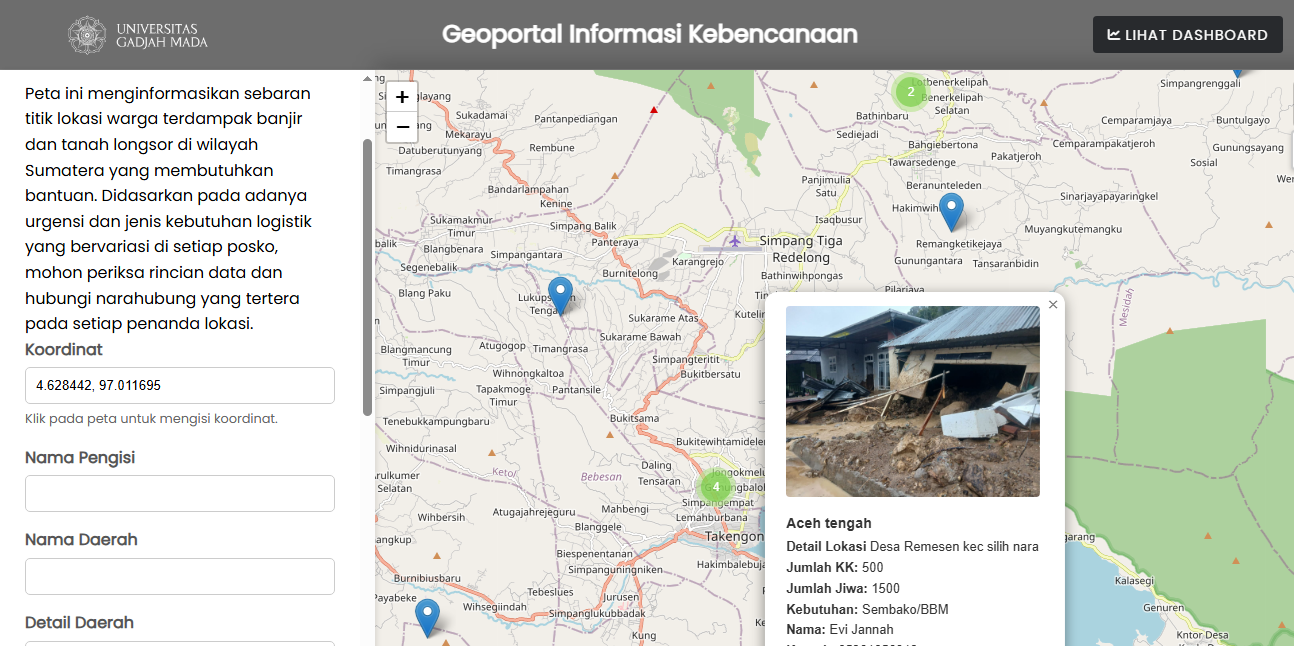
[1] OSM-based web map that allows survivors in Sumatra to map the disaster’s impact and pinpoint village locations requiring urgent logistical assistance. | © Gadjah Mada University | Map data © OpenStreetMap Contributors.
Mapping campaigns
- confusedbuffalo is proposing to extend their existing automated edit of phone numbers in the USA and UK to include Canada, removing extra punctuation and adding the country code. Mappers are invited to discuss this on the OSM Community forum and to get in touch if they think such an edit would also be useful and accepted in their country.
Community
- Raquel Dezidério Souto has published an entry in her OSM user diary about the tagging scheme developed for the collaborative mapping of beach accesses in OpenStreetMap. The researchers hope it can be useful to show how versatile OSM is, facilitating detailed mapping of these access points, as well as drawing attention to the value of beaches as public areas that should remain accessible to all.
- David Alberto has made a map that visualises the distribution of sundials in Europe using OpenStreetMap data (
amenity=clock+display=sundial). - Hobbesvsboyle gave an introductory presentation about OpenStreetMap to an audience of local bike advocates in Madison, Wisconsin. He has made the slides, notes, and a resource sheet available under a Creative Commons BY-SA license so that others can re-use it.
- Oldnab recounted several of his encounters during his mapping walks.
- Matteo Schizzerotto has transformed a car dashcam into a semi-automated OpenStreetMap pipeline complete with GPX extraction, a React/FastAPI helper app, data-based clip prioritisation, and Valhalla routing tweaks. This slashes manual work, highlights the most valuable footage, and directs surveys towards new roads.
OpenStreetMap Foundation
- The OSMF State of the Map Organising Committee has announced that the 2026 State of the Map will be held in Paris 28 to 30 August 2026. Visit 2026.stateofthemap.org for updates on speakers, the agenda, ticketing, and ways to get involved as the event approaches.
- Enock Seth Nyamador reported that twenty-five grantees of the State of the Map 2025 Travel Grant Programme were able to attend the event in Manila.
- The SotM 2026 Organising Committee is asking the community for a logo for the next SotM, to be held in Paris from 28 to 30 August 2026. Logo proposals should be submitted before 15 January 2026 23:59 UTC.
Local chapter news
- OSM Latam has opened
 ► submissions for the 2026 State of the Map Latam logo competition. Entries will be accepted until 9 January 2026, after which they will undergo community voting and a committee review. The winning design is scheduled to be revealed on 28 January 2026.
 ►
►
Education
- The Railways of the World YouTube channel has demonstrated how a navigation app works by using graph theory, OpenStreetMap data, and OSRM, in a video titled ‘How I Beat Google Maps With My Own Navigation App’.
- Paul has published, on AlternativeTo, an article titled ‘From quest‑hunting to cartographer‑craft: a guide to contributing to OpenStreetMap’, with an overview of popular software used with OSM.
Maps
- Osmldf announced ► that Architectes dans OSM, an initiative to enhance OpenStreetMap building data by adding their architects and construction dates, has transitioned to its own dedicated platform at mapaedifi.eu. There is also a uMap to visualise these features.
- dktue has made a plot of OSM data density and it is available in Wikimedia Commons, under a CC0 license.
 ►
►OSM in action
- [1] Gadjah Mada University has developed the ‘Geoportal Informasi Kebencanaan’, an OpenStreetMap-based web map that allows survivors of the recent floods and landslides in Sumatra to map the disaster’s impact and pinpoint village locations requiring urgent logistical assistance.
 the ‘Geoportal Informasi Kebencanaan’, an OpenStreetMap-based web map that allows survivors of the recent
 Open Data
- Mila Janovoso wrote about GlobalBuildingAtlas, an open global and complete dataset of building polygons, heights and LoD1 3D models. You can read the paper by Xiao Xiang Zhu (Technical University of Munich) and others published in Earth System Science Data.
Software
- An architecture student has created ArchiKEK to convert OpenStreetMap data into layered, design-ready SVGs for site analysis, offering one free high-resolution export with a style tailored for architectural use.
- From December 2025, Magic Earth will switch ► to a premium model for its navigation app, whereby key features such as offline maps and real-time traffic will only be available with a EUR 14.99/year subscription, while basic navigation will remain free of charge.
- OSM Wrapped is a cool platform that shows and celebrates key overall and annual contributions of OpenStreetMap members. Data is fetched from the HDYC Platform and OSM heatmap. Credits to Kennedy Kambi, Joseph Munienzy, Pascal Neis, and OpenStreetMap contributors.
 ►
►
Programming
- Astrid (aka aselnigu) has published in her diary about the lack of some road segments in OSM depending on the zoom level, as commented on the OpenStreetMap Community forum. The only difference between the two road segments was that the visible part contained one additional tag (
maxspeed=*) and she did some trials in the Lua language to understand what was happening.
Releases
- Christoph Hormann has released an updated Styleinfo analysis for both the Alternative Colours style and the OSM-Carto style, offering an overview of how each rendering approach presents OpenStreetMap data.
OSM in the media
- Johnny Harris speedran the Swiss rail system, using OpenHistoricalMap to explain Swiss history (segment from 4:30).
Other “geo” things
- IGN has built a beta for visualising CityGML LoD2 rendering of buildings based on their latest LiDAR survey.
- Miguel García Álvarez (aka Milhaud) has published ►, in the blog Mapas Milhaud, about a map that shows the mythical beasts of Germany, created in 2024 by Neil Parkinson, from Púca Printhouse. There are also mythical beasts maps of the Netherlands, Italy, Wales, Scotland, Iberia, England, France, Ireland, Canada, and more.
- Stefan Krempl, of Heise, reported that researchers have observed increasingly complex and intensified GNSS interference in the Baltic region, raising significant concerns about the operational safety of cargo and passenger vessels. The interference becomes markedly stronger in open waters, suggesting the possible involvement of a high-powered military system.
- Stadia Maps enables developers to add real-time and predictive traffic data to their routing API, giving users accurate ETAs based on live conditions and historical trends without changing their integration or sacrificing privacy.
- Bart Holterman et al. have developed Viabundus, an online map of long-distance routes in late medieval and early modern Europe (1350–1650).
Upcoming Events
| Country | Where | Venue | What | When |
|---|---|---|---|---|
 | Online | OpenStreetMap Midwest Meetup  | 2025-12-11 | |
| OSMF Engineering Working Group meeting | 2025-12-12 | |||
 | Berlin | Lucia Weihnachtsmarkt | 210. OSM-Stammtisch Berlin-Brandenburg | 2025-12-12 |
 | Zürich | Bitwäscherei Zürich | 182. OSM-Stammtisch Zürich | 2025-12-12 |
 | Zaragoza | Etopia | GeoCamp – State of the Map España 2025 | 2025-12-13 |
 | MAP Mercator museum | OpenStreetMap Belgium at the MAP-Mercator museum | 2025-12-13 | |
 | Jalpaiguri | Thana More | 10th OpenStreetMap West Bengal Mapping Party | 2025-12-13 |
| Navi Mumbai | Smt. Indira Gandhi College of Engineering (SIGCE) | Outdoor Mapping Party @ MiniDebConf, Mumbai | 2025-12-14 |
 | København | Cafe Bevar’s | OSMmapperCPH | 2025-12-14 |
| Hannover | Kuriosum | OSM-Stammtisch Hannover | 2025-12-15 |
 | Budapest | Cartographia Kft. | OSM térképest – december | 2025-12-16 |
| Madrid | Online | Mappy Hour OSM España | 2025-12-16 |
| Missing Maps London: (Online) Mid-Month Mapathon [eng] | 2025-12-16 | |||
 | Lyon | Tubà | Réunion du groupe local de Lyon | 2025-12-16 |
| Bonn | Dotty’s | 195. OSM-Stammtisch Bonn | 2025-12-16 |
 | City of Westminster | Monkey Puzzle pub | London xmas pub meet-up | 2025-12-16 |
| Online | Lüneburger Mappertreffen | 2025-12-16 | |
| Réunion du groupe local de Vienne | 2025-12-17 | ||
| Düsseldorf | Online bei https://meet.jit.si/OSM-DUS-2025 | Düsseldorfer OpenStreetMap-Treffen (online) | 2025-12-17 |
| Karlsruhe | Chiang Mai | Stammtisch Karlsruhe | 2025-12-17 |
 | Stainach-Pürgg | Online | 19. Österreichischer OSM-Stammtisch (online) | 2025-12-18 |
| UN Mappers Mappy Hour | 2025-12-19 | |||
| Potsdam | Luisenplatz, Potsdamer Weihnachtsmarkt | Potsdamer Mappertreffen | 2025-12-19 |
| Kalyani Nagar | TomTom, Shanti One, Ramwadi, Pune | Indoor Mapping Party @ TomTom Pune | 2025-12-20 |
| MAP Mercator museum | OpenStreetMap Belgium at the MAP-Mercator museum | 2025-12-20 | |
| Missing Maps : Mapathon en ligne – CartONG [fr] | 2025-12-22 | |||
| MAP Mercator museum | OpenStreetMap Belgium at the MAP-Mercator museum | 2025-12-27 | |
| New Delhi | online | OSM India×TomTom Online Mapathon | 2025-12-28 |
Note:
If you like to see your event here, please put it into the OSM calendar. Only data which is there, will appear in weeklyOSM.
This weeklyOSM was produced by MatthiasMatthias, Raquel Dezidério Souto, Robot8A, Andrew Davidson, barefootstache, derFred, mcliquid, s8321414.
We welcome link suggestions for the next issue via this form and look forward to your contributions.