19/12/2017-25/12/2017

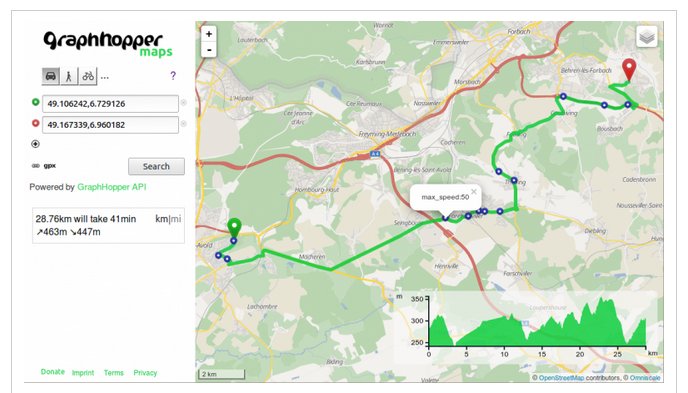
Display all different maximum allowed speed values along the path 1 | © OpenStreetMap Contriubutors © Graphhopper
Mapping
- DevSeed announces their Data Team for humanitarian response, professional geospatial data management and machine learning. To better support their partners’ missions, they are closely partnering with Mapbox to expand their mapping capacity. Effective immediately, the Mapbox data team Peru will operate as part of Development Seed and form the core of the DevSeed Data Team.
- The voting for the tagging of Magnetic levitation monorail has been running since October 6th.
Community
- Björn wants to know whether you can create a PDF file directly from an OpenStreetMap URL.
- User Zverik reports in his blog that Maps.Me performs routing via subway and light_rail relations.
- TheSilphRoad is a site that investigates the game of Pokémon Go. A published article helps Trainers understand what OSM is and how to contribute in useful ways.
- Wille writes a diary announcing a mailing list for OSMCha. This mailing list will be vital to ask general questions, make announcements regarding OSMCha, collaborate on plans and new features, and inform the group of changes.
Imports
- Sometimes it helps to get things out of your system – someone mapping in Calistoga has added a self-described rant about the problems that come with mapping in an area dominated by bad imports. The forum replies and explains what happened, and say that thankfully even in this area such problems are largely a thing of the past.
Events
- Oliver Rudzick promotes the OSGeo Code Sprint 2018 at the BaseCamp in Bonn and recommends a fast reservation because of the limited but interesting overnight stays. the sprint will take place parallel to the FOSSGIS conference. As Michael Reichert emphasizes, the OSM Saturday will take place on March 24th.
- FOSS4G will take place in the new year 2018 in Dar es Salaam.
- For April 13-14th 2018 the Polish community has organized a State of the map conference in Poznan.
Maps
- Bernd Weigelt discovers another way to install maps with hillshading for the Germany-Austria-Switzerland area on Garmin devices.
- Oleksiy Muzalyev presents his new multilingual web application, Travel Info Pack. It lets the user select a category of POI to display prominently on a map, and additionally offers a search for nearby Wikimedia images.
Software
- OsmAnd is available in version 2.0 for Apple’s iOS operating system. The most notable new feature is the routing function. The app can be downloaded from the iTunes Store.
Programming
- The latest version of GraphHopper’s Routing API offers new capabilities: path details and an “avoid” feature. Other GraphHopper APIs also receive updates.
- Jason Remillard wants to train a deep learning algorithm to recognise baseball pitches using OSM data as the training set. His code is on github.
Releases
- Vespucci the editor for use on mobile devices has a major release and leaps from v0.9.9 to version 10.
- internal validator re-factored
- C-Mode presets
- Support for custom tasks
- The new version of Mapbox Maps SDK for Android v5.3.0 comes with a new name, improved CJK performance and much more.
- Mapbox Navigation SDK for Android v0.8.0 release comes with event listeners when using the prebuilt UI, fixed audible SSML tags in voice instructions, and custom notifications.
Other “geo” things
- WeltN24 reports
(Google translate) about the recent inauguration of the Zugspitze cable car, which breaks three world records. The cable car is of course already mapped in OpenStreetMap.
- Who will create the maps in the future? Man, machines or both together? A blog article from Mapillary wants to find answers.
- Justin O’Beirne published a detailed blog post on the status of Google Maps compared to Apple Maps, which also includes Google’s intensive use of machine learning. O’Beirne feels that Google Maps’ wealth of information seems overwhelming. On Twitter @vtcraghead shares his thoughts on how the OpenStreetMap community should deal with this.
- The interactive map of koeln.de shows the zone without fireworks and barriers to New Year’s Eve in Cologne, Germany.
- Members from OSGEO (Open Source Geospatial Foundation) developed OpenDroneMap.org, an open source project for processing aerial drone imagery, over the past 5 years. There is no direct relation with OpenStreetMap. You can find a more detailed explanation on how it works here
- Ian Dees writes on the Mapzen blog about a project that collects addresses for branch locations from operators’ websites. The data is then converted to a more useful format (GeoJSON) and made available at alltheplaces.xyz under a Creative Commons’ CC-0 waiver license.
Upcoming Events
| Where | What | When | Country |
|---|---|---|---|
| Denver Online High School Mitchell | PoliMappers’ Adventures: One mapping quest each day | 2017-12-01-Invalid date | |
| Montreal | Les Mercredis cartographie | 2018-01-03 | |
| Albuquerque | MAPABQ (join us!) | 2018-01-03 | |
| Stuttgart | Stuttgarter Stammtisch | 2018-01-03 | |
| Passau | Niederbayerntreffen | 2018-01-08 | |
| Lyon | Rencontre libre mensuelle | 2018-01-09 | |
| Nantes | Réunion mensuelle | 2018-01-09 | |
| Berlin | 115. Berlin-Brandenburg Stammtisch | 2018-01-11 | |
| Tokyo | 東京!街歩き!マッピングパーティ:第15回 品川神社 | 2018-01-13 | |
| Kyoto | 幕末京都マッピングパーティ#01:京の町家と大獄と | 2018-01-13 | |
| Brisbane | Brisbane Photo Mapping | 2018-01-13 | |
| Rome | FOSS4G-IT 2018 | 2018-02-19-2018-02-22 | |
| Cologne Bonn Airport | FOSSGIS 2018 | 2018-03-21-2018-03-24 | |
| Poznań | State of the Map Poland 2018 | 2018-04-13-2018-04-14 | |
| Bordeaux | State of the Map France 2018 | 2018-06-01-2018-06-03 | |
| Milan | State of the Map 2018 (international conference) | 2018-07-28-2018-07-30 |
Note: If you like to see your event here, please put it into the calendar. Only data which is there, will appear in weeklyOSM. Please check your event in our public calendar preview and correct it, where appropriate.
This weeklyOSM was produced by Nakaner, Polyglot, SK53, Spanholz, Tordanik, derFred, jinalfoflia, sev_osm.