16/10/2018-22/10/2018
XCTrails – the map for climbing routes fully based on OSM data [1] | © a.müller @xctrails.org | map data © OpenStreetMap contributors
Mapping
- Dabohamda announced in a tweet
 the creation of the first bus line in Conakry following a field survey. OpenStreetMap Guinea will complete the bus network in the coming days. (automatic translation)
 - Satoshi Iida (User nyampire) announced last week on Twitter(1, 2)
 about fresh aerial imagery for Japan. OSM now has permission to use aerial imagery published as open data from Nerima-ku (specified districts in Tokyo Metropolis) and Fukaya city. He created map tiles and explains how to use them on the wiki Nerima-ku (automatic translation) and Fukaya (automatic translation). The imagery is of very high resolution, which will help us to enrich OSM.
 - Martin Koppenhoefer asks on the mailing list whether the decision of the Data Working Group regarding the Crimean peninsula should be changed. Russia has been in control of the area for four years and changes are not expected.
- Frederik Ramm of the DWG warns on the Talk-de
 (automatic translation) mailing list and in the German forum (automatic translation) that users who continue to participate in verbal fights in changeset comments of new users against or for ‘gluing’ landuse areas to other features will be temporarily blocked from editing. He also started a discussion (automatic translation) about this topic to try and resolve one of the oldest contentious issues in OSM, i.e. the gluing of linear features to area features. Mappers pro gluing don’t want to leave blank artefacts in between when rendering at high zoom levels; mappers against find it is extremely time consuming to do further editing when glued together.
 - Researchers at Cardiff University have used OSM data to develop a novel method for finding the safest routes for pedestrians. Their work is to be published in the journal Accident Analysis & Prevention.
- Joseph Eisenberg suggests bringing some order to the tagging of hot springs and geysers. The current tagging goes back to a proposal from 2008 that was never approved.
- Gregory Marler presents the 360° cameras which are available for hire from OSM UK for its members in an unboxing video on YouTube.
- With a mail to the tagging list, Allan Mustard draws attention to the proposal about distinguishing embassies from consulates. The aim of the proposal is to bring structure to the current set of informal tagging rules, to let OSM reflect international law.
Community
- The user Adrian O´Connor shares a tweet about the launch of OpenStreetMap Ireland at Maynooth University. Ciarán Staunton (aka DeBigC) reports the founding of OpenStreetMap Ireland, which aims to become the local chapter of the OSMF in Ireland.
- Simon Poole has submitted a pull request that will add links to new OSM Terms of Use in the Welcome box and on the About page.
Imports
- An import of natural monument trees in the Italian region Friuli Venezia Giulia is planned. Giovanni has created a wiki site and is looking for help.
- Leif Rasmussen announced a ready-to-go import for missing buildings and address data in Miami-Dade County.
- update An import of electric charging station for cars in Norway, Sweden and Finland is currently in preparation. As outlined in the wiki page, electric charging stations are quite important in Scandinavia as nearly 50% of all cars sold in Norway are electric cars or plug-in hybrids.
- While most imports are carefully prepared, documented and discussed, some aren’t. As reported on the Canadian mailing list, a mapper added administrative boundaries in a questionable way and ignored comments from community members.
OpenStreetMap Foundation
- The draft meeting minutes for the License Working Group meeting of October 11th were published.
- The meeting minutes of the recent OSMF Board have been published.
Events
- Opensaar e.V., a German FOSS organisation, will host a meet&talk on November 15th at Saarbrücken in Germany. In addition to talks about OGC standards, Mapserver, Postgis and QGIS, Guillaume Rischard (OSM: Stereo) will talk about the experience with open geodata in Luxembourg.
Humanitarian OSM
- The OSM GeoWeek will take place between November 11-17th. OSM GeoWeek is a celebration of geography and map making with OpenStreetMap. Last year there were 230 events in 48 countries. The homepage of the OSM GeoWeek helps you to find or register an event.
- HOT endorsed the Principles for Digital Development, which comprise nine guidelines designed to help digital development practitioners integrate established best practices into technology-enabled programs.
Maps
- The association “Atvirasis žemėlapis” (The Open Map) together with SpatialForces released a topographical vector map of Lithuania. The map combines OSM data, the SwissTopo style with some minor adjustments and LiDAR based dynamic high resolution hillshading. Further details are described in a blogpost.
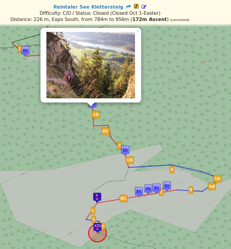
- XCTrails Map provides a dedicated map for climbing routes fully based on OSM data.
Software
- OsmAnd seems
 (automatic translation) to partially meet the needs of firefighters, but favourites with links to PDFs (e.g. floor plans) would be very helpful. A user is looking for help in the German OSM forum.
Programming
- Coder superDoss provided a pull request for iD, that enables it to read and display data in shapefile format.
Releases
- Daniel Koć announced the release of OpenStreetMap Carto 4.16.0, that brings a bunch of new icons and renderings. There have been a few comments on why ATMs and post boxes are now rendered only at zoom level 19+, and the discussion on the list indicates that it was not a simple decision.
- Please check the OSM Software Watchlist of Wambacher for the latest releases of all OSM software.
Did you know …
- … about the possibility to use (automatic translation) mailing lists as a forum?
Other “geo” things
- A visualisation of rivers in the US based on their average annual flow has been posted on reddit.com/r/MapPorn.
- The blog on singletracks.com, a site dedicated to mountain biking, has published a test of the outdoor GPS Wahoo Elemnt, that uses OSM maps.
- The website geospatialworld.com published an article about the increasing importance of satellite imagery for journalism. Aerial views have become indispensable for journalists who want to double check the location of a scene, document deforestation, illustrate devastation of urban areas in recent conflicts and many other purposes.
- The World Food Programme posted an update about the situation in Nepal. The region suffers from extreme food shortage on a large scale. An OpenStreetMap-based pilot project on trail and infrastructure mapping in the Jumla district concluded in September.
Upcoming Events
| Where | What | When | Country |
|---|---|---|---|
| Manila | 【MapaTime!】 @ co.lab | 2018-10-27 |  |
| Rennes | Recensement des commerces du centre-ville | 2018-10-28 |  |
| Melbourne | Papua New Guinea Malaria Mapathon | 2018-10-31 |  |
| Toronto | Mappy Hour | 2018-11-05 |  |
| Lyon | Rencontre mensuelle pour tous | 2018-11-13 | |
| Mumble Creek | OpenStreetMap Foundation public board meeting | 2018-11-15 |  |
| Bengaluru | State of the Map Asia 2018 | 2018-11-17-2018-11-18 |  |
| Melbourne | FOSS4G SotM Oceania 2018 | 2018-11-20-2018-11-23 | |
| online via IRC | Foundation Annual General Meeting | 2018-12-15 | |
| Heidelberg | State of the Map 2019 (international conference) | 2019-09-21-2019-09-23 |  |
Note: If you like to see your event here, please put it into the calendar. Only data which is there, will appear in weeklyOSM. Please check your event in our public calendar preview and correct it, where appropriate.
This weeklyOSM was produced by Anne Ghisla, Nakaner, Polyglot, Rogehm, SunCobalt, TheSwavu, YoViajo, derFred, geologist, jinalfoflia, k_zoar, keithonearth.