18/12/2018-24/12/2018
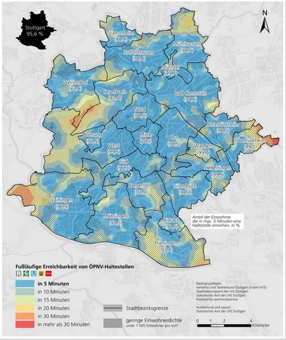
Walking time to the nearest public transport stop 1 | © City of Stuttgart © Map data OpenStreetMap contributors
Mapping
- OSM South Africa are raising funds on GoFundMe to purchase historical topographic maps of Namibia. If funding is successful, the maps will be tiled for use in OSM editors, just like the topo maps of South Africa itself which are already available.
- Peter Elderson wants to revive the
highway=trailheadproposal from 2015. According to his post on the tagging mailing list, in the Netherlands mappers have added the tag at all starting points for trails which have some infrastructure (parking, information, etc). However, there is some confusion over whether the term trailhead is appropriate for the purpose and who is already using it in OSM. - Apple has posted potential data problems in Korea such as building-road intersections, highway links without classification and roads with excessively sharp angles to MapRoulette where the challenges can be solved by volunteers.
- Apple announced that they will map buildings in Buenos Aires manually using imagery sources and GPS resources.
- On Techcrunch.com, Jon Russell reports how Grab is jamming the OSM community in Thailand by making inferior changes. The article quotes a local mapper with the words “OpenStreetMap is mostly craft, but they [Grab] attack OSM with an industrial mentality”. The article also mentions that 100 employees of Grab’s mapping subcontractor GlobalLogic of India have become members of the OSMF.
- Grab responded to the critical TechCrunch article: Bangkok mapper Mishari Muqbil provides an extended reply to Grab’s press release.
- The German community continued their annual ritual and mapped Christmas market features that can be seen on the Christmas market map (loads slowly). The fact that the map is quite D-A-CH-centric may be a result of the insufficient translation of the wiki site but more likely relates to the German passion for this kind of market.
Community
- Phase 2 of Community Africa Francophone for Open Data (CAFDO) mini-grants (automatic translation) funded various OpenStreetMap activities organised by members of local communities in Western Africa: a mapathon in Koutiala, Mali; one week of training in Zinder, Niger; mapping of tourism-related objects in Ouidah, Bénin; a three-day training dedicated to ladies in Ivory Coast; a promotional workshop in Burkina Faso and a conference for local authorities in Senegal.
OpenStreetMap Foundation
- There are discussions in Australia to set up a local Open Source Geospatial organisation OSGeo Oceania as an OSMF local chapter.
Humanitarian OSM
- The minutes of the board meeting of HOT US Inc. on December 6 have been published. The topics discussed during the meeting included the setup of an advisory board and the planned registration of a European branch in order to be eligible for EU programmes.
- HOT announced a partnership with tech hub iLab Liberia and the local OSM community to introduce the Open Cities Monrovia project. As 90 percent of the population in Monrovia is living in areas with very high flood risk, the project aims to improve understanding of unplanned settlements and make the slum communities more resilient to natural disasters.
- The project mamapa is teaching immigrants in Germany to contribute to international humanitarian mapping initiatives. The project, which is supported by BASF (Ludwigshafen) and CartONG, helps in a number of ways, i.e. assisting the activity of humanitarian relief staff on the ground, teaching immigrants new skills in geography and modern cartography, hastening their integration into German society and providing a directly appreciated humanitarian contribution.
Maps
Open Data
- The Open Data Institute (London) announced four successful bids for funding under their local open geospatial data initiative. Two of these, maybe more, make use of OpenStreetMap data: in Oxfordshire local mappers and cycle advocacy groups will work with the council to improve cycle infrastructure, whilst Falkirk aims to improve access by community groups and individuals to a range of facilities.
Software
- Stefan Keller announced (automatic translation), on the Swiss mailing list, an experimental tool for converting free text (German only) to the OSM opening hour syntax. Two different approaches are available for testing.
- Fabian Schütt from the Statistical Office of the City of Stuttgart determined the walking time to the nearest public transport stop for every place in the city using the QGIS plugin OSM Tools from HeiGIT, which makes the functions of openrouteservice – such as routing, isochrones and matrix calculations – available to QGIS users.
- Nils Nolde from Heidelberg Institute for Geoinformation Technology (HeiGIT) announced openelevationservice as a new endpoint within the openrouteservice API ecosystem. It queries a remote DEM for every vertex of a LineString or Point geometry and enriches those with altitude values. Ituses SRTM v4.1 as a start and you can easily test it using the interactive documentation in the API playground, even without programming.
- Simon Poole provides some hints as to new features in forthcoming versions of Vespucci. Firstly, in a diary post, he explains how he has tiled OSM data for offline use in the editor. Secondly, he demos some work-in-progress on adding functionality to enable editing of turn restrictions.
Programming
- Stephan Bösch-Plepelits made some changes to the Leaflet.TextPath library.
- And here comes another little Christmas present from HeiGIT: In addition to their highly appreciated Python and R libraries HeiGIT Institute now offers an additional JavaScript API making it simple to use the openrouteservice ecosystem, covering the entire globe based on OSM, in web applications.
Releases
Did you know …
- … this article from a year ago in which SeverinGeo explains why he thinks that the HOT US Inc governance should not to be replicated in the OSM Foundation.
Other “geo” things
- Matthew Flint found an old, 1950s, town plan of Cardiff in a second-hand bookshop. It uses a very unusual radial grid for locating streets.
- OSM contributor Mick Hicks tweets about how the extensive use of cul-de-sacs (dead-end streets) in suburban road layouts in the US over the past few decades makes the effective provision of public transport very difficult. He remarks both on his own observations from correcting TIGER data in Minnesota, and on recent press coverage of bus transport in Colorado Springs.
- The BBC reports about account closures of Slack users who have ever visited a country imposed with US sanctions (e.g. Cuba, Iran, the Crimean Peninsula) or are citizens of such a country (via HOT mailing list).
- The Guardian has a long article about Google’s commercial relationships with several US intelligence (spy) agencies. Google’s geospatial offerings, notably Google Earth, were a critical component in building this business.
Upcoming Events
| Where | What | When | Country |
|---|---|---|---|
| Alice | PoliMappers Adventures 2018: One mapping quest each day | 2018-12-01-2018-12-31 |  |
| Leipzig | OpenStreetMap assembly | 2018-12-27-2018-12-30 |  |
| Biella | Incontro mensile | 2018-12-29 |  |
| Stuttgart | Stuttgarter Stammtisch | 2019-01-02 | |
| Lyon | Rencontre mensuelle pour tous | 2019-01-08 |  |
| Dresden | Stammtisch Dresden | 2019-01-10 | |
| Berlin | 127. Berlin-Brandenburg Stammtisch | 2019-01-10 | |
| Nantes | Réunion mensuelle | 2019-01-10 | |
| Rennes | Réunion mensuelle | 2019-01-14 | |
| Toulouse | Rencontre mensuelle | 2019-01-16 | |
| Karlsruhe | Stammtisch | 2019-01-16 | |
| Salzburg | Maptime – Stammtisch | 2019-01-16 |  |
| Freiberg | Stammtisch Freiberg | 2019-01-17 | |
| Leoben | Stammtisch Obersteiermark | 2019-01-17 | |
| Reutti | Stammtisch Ulmer Alb | 2019-01-22 | |
| Lübeck | Lübecker Mappertreffen | 2019-01-24 | |
| Greater Vancouver area | Metrotown mappy Hour | 2019-01-25 |  |
| Bremen | Bremer Mappertreffen | 2019-01-28 | |
| Montpellier | State of the Map France 2019 | 2019-06-01-2019-06-03 | |
| Heidelberg | HOT Summit 2019 | 2019-09-19-2019-09-20 | |
| Heidelberg | State of the Map 2019 (international conference) | 2019-09-21-2019-09-23 | |
| Grand-Bassam | State of the Map Africa 2019 | 2019-11-22-2019-11-24 |  |
Note: If you like to see your event here, please put it into the calendar. Only data which is there, will appear in weeklyOSM. Please check your event in our public calendar preview and correct it, where appropriate.
This weeklyOSM was produced by Nakaner, PierZen, Polyglot, Rogehm, SK53, SeverinGeo, SunCobalt, TheSwavu, derFred, jcoupey.
Thanks and a Happy New Year