22/08/2023-28/08/2023
How to map part-time contraflow road? [1] © marche_ck | map data © OpenStreetMap contributors
Mapping
- Requests have been made for comments on the following proposals:
information=public_transport_information_deskfor tagging a place where you can get information and help from a public transport company but can’t buy tickets.free_period_products=yesto indicate if a toilet has free period products available.
Mapping campaigns
- ꞴetaNYC has organised a community project to map public facilities in North Brooklyn, New York, USA.
Community
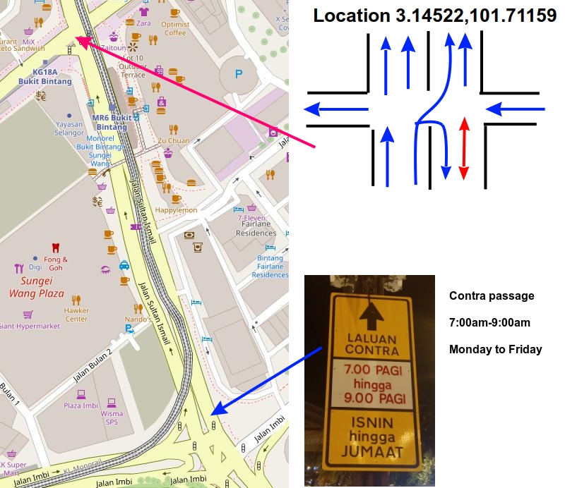
- [1] marche_ck has found a complex crossing on Jalan Sultan Ismail, Kuala Lumpur and sketched out how he imagines he would map it in OSM.
- iigmir discussed some possible OSM tags for tagging ‘Farmer Community Cooperatives’ that they found in the Taiwan, China, Korea, and Japan region. In Indonesia, this is called a ‘Village Unit Cooperative’.
- Jens-Uwe Hagenah blogged
 ► his thoughts on how to best tag long-distance cycle routes and their signposts.
 - barefootstache wrote about their intention to follow up ‘365 days of mapping’ with a series of 100 weekly mapping challenges.
- Kamil Monicz (NorthCrab) commented about the new donation request banner on the main OSM page and on the OSM 2023 budget.
- Contributor OMNIBUS has published a status report on his guidelines for mapping wetlands and flood zones.
- Keen Quispe, of OpenStreetMap Peru, published ► an essay proposing the integration of OpenStreetMap into the educational system’s curriculum.
- Robhubi asked ► himself why Himmelreich, Raaba-Grambach, Germany, is incorrectly mapped in OSM and did some research on this matter. It seems to be an historical anomaly, so he wants to know if it is possible to update its location.
 ►
►
 ►
►Events
- Anne-Karoline Distel shared her experience of introducing OpenStreetMap to local communities during Ireland’s Heritage Week 2023.
OSM research
- HeiGIT tooted some statistics on the age of OSM objects based on the time of the last edit.
Humanitarian OSM
- A discussion on ‘map data access through HOTOSM Tasking Manager’ has been opened and is seeking public comments on the topic.
Maps
- Brian Sperlongano has announced the release of the tile.ourmap.us community vector tile server. This is a full planet OSM vector tile server that updates approximately every 10 hours, primarily intended for personal, non-commercial use.
switch2OSM
- Josh Carlson tooted that Kendall county, Illinois, is now a corporate support member for OpenStreetMap and celebrates becoming a foundation member.
Open Data
- The AddressForAll Institute, in partnership with Esri, has begun to release open data packages provided by hundreds of municipalities in Brazil and other countries. These are maps of street, plots, buildings, neighbourhood boundaries, address points, and city blocks, which can be loaded onto QGIS or JOSM to improve OpenStreetMap. The data will be available under CC0 and CC-BY licenses. The first city is Cachoeiro do Itapemirim/ES, Brazil. Feedback for future releases is welcome.
 open data packages provided by hundreds of municipalities in Brazil and other countries. These are maps of street, plots, buildings, neighbourhood boundaries, address points, and city blocks, which can be loaded onto QGIS or JOSM to improve OpenStreetMap. The data will be available under CC0 and CC-BY licenses. The first city is Cachoeiro do Itapemirim/ES, Brazil. Feedback for future releases is welcome.
Software
- MapTiler has released a map style editor to make it easier for users to design their own maps.
- Ben Clark announced the release of Rapid version 2.1 that includes two new features that will bring more attention to map data gaps:
- A 3D building renderer in an inset map
- The ability to load and visualise more custom data with protomaps MPTiles support.
- Sarabjeet Sodhi blogged about supporting Vespucci preset extensions in JOSM. Vespucci utilises the JOSM preset format but has extended the configuration to work better outside of the narrow realm of JOSM. These extensions include deprecated, regions, exclude_regions, value_type, and alternative.
- ybon gave an update on uMap, which has been integrated in a French state incubator, and has received quite a few updates: custom overlays, anonymous edit links sent by email, facet search, dashboards, and profile updates – to name only a few. He also listed what is planned next and how you can contribute by coding, testing, translating, or funding.
Programming
- darkonus shared a script that can enhance your experience with JOSM on MacOS by enabling a dark mode theme.
- miku0 has posted a final update on their Google Summer of Code project enhancing Nominatim’s address search in Japan.
Releases
- Mapilio street-level images are now integrated into the OpenStreetMap iD Editor.
Other “geo” things
- Yandex is looking ► for a developer to work on their OpenStreetMap content moderation system. The work is in a hybrid format: 3 days in the office, 2 days at home, flexible schedule; main offices are in Moscow and Belgrade.
 ►
►Upcoming Events
| Where | What | Online | When | Country |
|---|---|---|---|---|
| Maricá | Mapathon – Maricá City | 2023-08-24 – 2023-09-24 |  | |
| Localidad Teusaquillo | Volvamos a cerrar notas de OSM en Colombia – Notathon | 2023-09-02 |  | |
| Stadtgebiet Bremen | Mappingparty in Bremen | 2023-09-03 |  | |
| Missing Maps London Mapathon | 2023-09-05 | |||
| Berlin | OSM-Verkehrswende #51 | ✓ | 2023-09-05 | |
| OSMF Engineering Working Group meeting | 2023-09-06 | |||
| Stuttgart | Stuttgarter OpenStreetMap-Treffen | 2023-09-06 | | |
| Stadt Dornbirn | OpenData + OSM Meetup Vorarlberg | 2023-09-06 |  | |
| Amsterdam | Maptime Amsterdam 2.0 | 2023-09-08 |  | |
| Bengaluru | OSM Bengaluru Mapping Party | 2023-09-09 |  | |
| København | OSMmapperCPH | 2023-09-10 |  | |
| Zürich | OSM-Stammtisch | 2023-09-11 |  | |
| 臺北市 | OpenStreetMap x Wikidata 月聚會 #56 | 2023-09-11 |  | |
| San Jose | South Bay Map Night | ✓ | 2023-09-13 |  |
| Middelburg | FOSS4G-NL | 2023-09-13 – 2023-09-14 | | |
| Stainach-Pürgg | 10. Österreichischer OSM-Stammtisch (online) | 2023-09-13 | | |
| Lorain County | OpenStreetMap Ohio+Michigan Meetup | ✓ | 2023-09-14 | |
| Potsdam | 183. Berlin-Brandenburg OpenStreetMap Stammtisch | 2023-09-14 | | |
| München | Münchner OSM-Treffen | 2023-09-14 | |
Note:
If you like to see your event here, please put it into the OSM calendar. Only data which is there, will appear in weeklyOSM.
This weeklyOSM was produced by Elizabete, MatthiasMatthias, PierZen, TheSwavu, TrickyFoxy, YoViajo, adiatmad, barefootstache, derFred, rtnf.
We welcome link suggestions for the next issue via this form and look forward to your contributions.